
File:NorthAreaCodeEvolution.JPG

Size of this preview: 800 × 155 pixels. Other resolution: 1,082 × 209 pixels.
Original file (1,082 × 209 pixels, file size: 68 KB, MIME type: image/jpeg)
| This is a file from the Wikimedia Commons. Information from its description page there is shown below. Commons is a freely licensed media file repository. You can help. |
Summary
| Description |
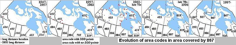
English: Evoloution of Area Codes 867 and related.;1947–1957: No places in Canada had DDD, therefore all area codes are shown in italics. The area codes were mainly used as operator references to reach other operators ("inward") to complete calls. Only Whitehorse had an exchange with long distance connections; the only other exchanges in the Yukon were in Mayo and Dawson, which were not connected to long distance.
|
| Date | |
| Source | I created this work entirely by myself. |
| Author | GBC (talk) |

|
This map image could be re-created using vector graphics as an SVG file. This has several advantages; see Commons:Media for cleanup for more information. If an SVG form of this image is available, please upload it and afterwards replace this template with
{{vector version available|new image name}}.
It is recommended to name the SVG file “NorthAreaCodeEvolution.svg”—then the template Vector version available (or Vva) does not need the new image name parameter. |


Licensing
Gcapp1959 at English Wikipedia, the copyright holder of this work, hereby publishes it under the following licenses:
This file is licensed under the Creative Commons Attribution-Share Alike 3.0 Unported license.
Attribution: Gcapp1959 at English Wikipedia
- You are free:
- to share – to copy, distribute and transmit the work
- to remix – to adapt the work
- Under the following conditions:
- attribution – You must give appropriate credit, provide a link to the license, and indicate if changes were made. You may do so in any reasonable manner, but not in any way that suggests the licensor endorses you or your use.
- share alike – If you remix, transform, or build upon the material, you must distribute your contributions under the same or compatible license as the original.

|
Permission is granted to copy, distribute and/or modify this document under the terms of the GNU Free Documentation License, Version 1.2 or any later version published by the Free Software Foundation; with no Invariant Sections, no Front-Cover Texts, and no Back-Cover Texts. A copy of the license is included in the section entitled GNU Free Documentation License. |
You may select the license of your choice.
Original upload log
The original description page was here. All following user names refer to en.wikipedia.
| Date/Time | Dimensions | User | Comment |
|---|---|---|---|
| 2011-11-24 14:37:46 | 1082 × 209 | S1312 | 780 was not created until 1999 |
| 2008-09-07 08:18:14 | 1082 × 209 | Gcapp1959 | Author: GCapp1959. |
| 2008-09-07 08:03:00 | 1082 × 209 | Gcapp1959 | {{Information |Description= |Source=I created this work entirely by myself. |Date= |Author=~~~ |other_versions= }} Red dots indicating long distance points are not all shown after 1957-1962 map. Area codes shown in italics did not have dialable locations |

|
This media file is uncategorized.
Please help improve this media file by adding it to one or more categories, so it may be associated with related media files (how?), and so that it can be more easily found.
Please notify the uploader with {{subst:Please link images|File:NorthAreaCodeEvolution.JPG}} ~~~~ |
File history
Click on a date/time to view the file as it appeared at that time.
| Date/Time | Thumbnail | Dimensions | User | Comment | |
|---|---|---|---|---|---|
| current | 02:00, 16 December 2018 | 1,082 × 209 (68 KB) | OgreBot | (BOT): Reverting to most recent version before archival | |
| 02:00, 16 December 2018 | 1,082 × 209 (68 KB) | OgreBot | (BOT): Uploading old version of file from en.wikipedia; originally uploaded on 2008-09-07 08:18:14 by Gcapp1959 | ||
| 02:00, 16 December 2018 | 1,082 × 209 (68 KB) | OgreBot | (BOT): Uploading old version of file from en.wikipedia; originally uploaded on 2008-09-07 08:03:00 by Gcapp1959 | ||
| 00:44, 16 December 2018 | 1,082 × 209 (68 KB) | I love rpgs | Transferred from en.wikipedia (MTC!) (1.1.0) |
File usage
The following pages on the English Wikipedia use this file (pages on other projects are not listed):