
File:North Bovey, Stone Cross - geograph.org.uk - 884323.jpg
No higher resolution available.
North_Bovey,_Stone_Cross_-_geograph.org.uk_-_884323.jpg (640 × 427 pixels, file size: 181 KB, MIME type: image/jpeg)
| This is a file from the Wikimedia Commons. Information from its description page there is shown below. Commons is a freely licensed media file repository. You can help. |
Summary
| Description |
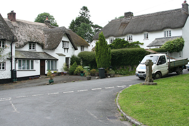
English: North Bovey: Stone Cross On the edge of the village green: the 18th century house opposite is named Stone Cross. According to the village guide, the original cross was broken down during the civil war and pieces of the original were found in the house in 1943. Another old cross was recovered from the Bovey Brook in 1829 by the Reverend Pike-Jones and erected on the base of the first |
| Date | |
| Source | From geograph.org.uk |
| Author | Martin Bodman |
| Attribution (required by the license) | Martin Bodman / North Bovey: Stone Cross / |
| Camera location | | View this and other nearby images on: OpenStreetMap |
|---|
_heading:292.00&language=en)
| Object location | | View this and other nearby images on: OpenStreetMap |
|---|
_heading:292.00&language=en)
Licensing

|
This image was taken from the Geograph project collection. See this photograph's page on the Geograph website for the photographer's contact details. The copyright on this image is owned by Martin Bodman and is licensed for reuse under the Creative Commons Attribution-ShareAlike 2.0 license.
|
This file is licensed under the Creative Commons Attribution-Share Alike 2.0 Generic license.
Attribution: Martin Bodman
- You are free:
- to share – to copy, distribute and transmit the work
- to remix – to adapt the work
- Under the following conditions:
- attribution – You must give appropriate credit, provide a link to the license, and indicate if changes were made. You may do so in any reasonable manner, but not in any way that suggests the licensor endorses you or your use.
- share alike – If you remix, transform, or build upon the material, you must distribute your contributions under the same or compatible license as the original.
File history
Click on a date/time to view the file as it appeared at that time.
| Date/Time | Thumbnail | Dimensions | User | Comment | |
|---|---|---|---|---|---|
| current | 13:01, 21 February 2011 | | 640 × 427 (181 KB) | GeographBot | == {{int:filedesc}} == {{Information |description={{en|1=North Bovey: Stone Cross On the edge of the village green: the 18th century house opposite is named Stone Cross. According to the village guide, the original cross was broken down during the civ |
File usage
The following pages on the English Wikipedia use this file (pages on other projects are not listed):