
File:PGkGeorgiev.png
Original file (619 × 617 pixels, file size: 309 KB, MIME type: image/png)
Summary[edit]
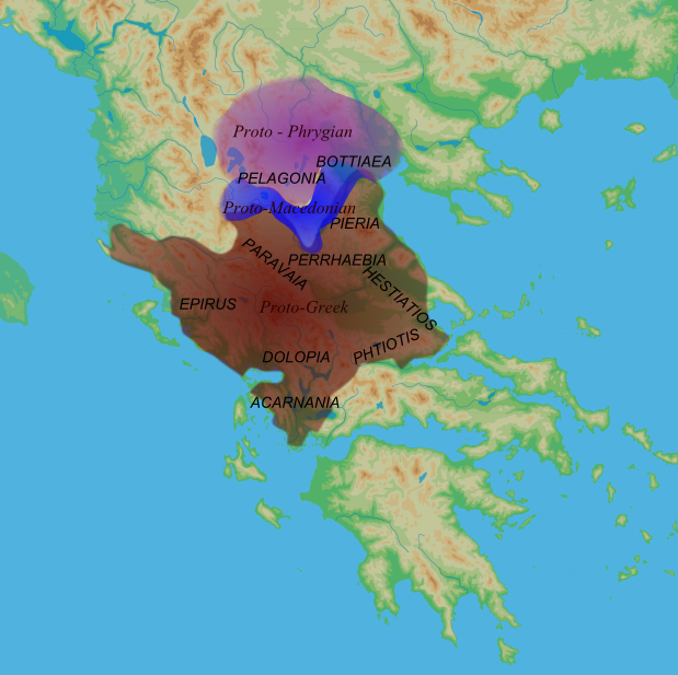
The Proto-Greek region according to Georgiev's proposal.
"The proto-Greek region included Epirus, approximately up to Aὕλῴν in the north including Paravaia, Tymphaia, Athamania, Dolopia, Amphilocia and Acarnania, west and north Thessaly (Hestiaitotis, Perrhaibaia, Tripolis and Pieria), ie more or less the territory of northwest Greece." Introduction to the History of the Indo-European Languages. V I Georgiev. Sofia, 1981. Pg 156
and
"On the basis of the distribution of the ancient toponymy the Balkan Peninsula can be divided into seven or eight basic ethnic regions:...Proto-Greek (Epirus, western and northern Thessaly), Macedonian (southern Macedonia, the basin of the Haliacmon RIver), Proto-Phrygian (north and central Macedonia, the basin of Erigon RIver). Pg 147-148.
Licensing[edit]
| This work is licensed under the Creative Commons Attribution 3.0 License. |
 | This file is a candidate to be copied to Wikimedia Commons.
Any user may perform this transfer; refer to Wikipedia:Moving files to Commons for details. If this file has problems with attribution, copyright, or is otherwise ineligible for Commons, then remove this tag and DO NOT transfer it; repeat violators may be blocked from editing. Other Instructions
| ||
| |||
File history
Click on a date/time to view the file as it appeared at that time.
| Date/Time | Thumbnail | Dimensions | User | Comment | |
|---|---|---|---|---|---|
| current | 03:23, 10 June 2011 | | 619 × 617 (309 KB) | Slovenski Volk (talk | contribs) | |
| 03:10, 10 June 2011 |  | 598 × 606 (273 KB) | Slovenski Volk (talk | contribs) | The Proto-Greek region according to Georgiev's proposal. "The proto-Greek region included Epirus, approximately up to Aὕλῴν in the north including Paravaia, Tymphaia, Athamania, Dolopia, Amphilocia and Acarnania, west and north Thessaly (Hestiaitoti |
You cannot overwrite this file.