
File:Percé Rock (3).jpg

Size of this preview: 800 × 531 pixels. Other resolutions: 320 × 213 pixels | 640 × 425 pixels | 1,024 × 680 pixels | 1,280 × 850 pixels | 2,560 × 1,700 pixels | 4,288 × 2,848 pixels.
Original file (4,288 × 2,848 pixels, file size: 13.22 MB, MIME type: image/jpeg)
| This is a file from the Wikimedia Commons. Information from its description page there is shown below. Commons is a freely licensed media file repository. You can help. |
.jpg)
Summary
| Description |
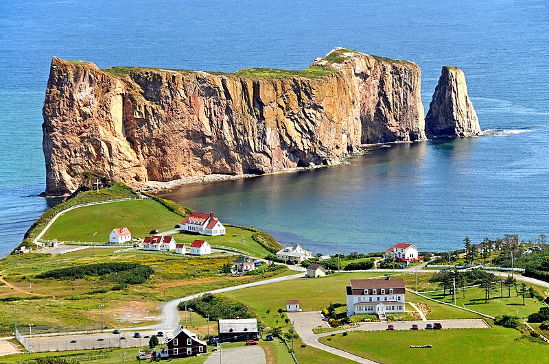
English: Percé (2006 Population 3,419) is a small village near the tip of the Gaspé Peninsula in Québec. It has a long history of being an important seasonal fishing centre under the French. Today the area is mainly a tourist location particularly well-known for the attractions of Percé Rock and Bonaventure Island.
Percé Rock is a natural rock formation located close to the shore facing the town. It is a natural tourist attraction for its size, color, and unusual door-like hole at one end the rock.
Français : Percé est une municipalité ( population de 3,419 personnes en 2006) située à l'extrémité est de la péninsule gaspésienne au Québec. Elle fut longtemps un important centre de pêche saisonnière sous le régime français. De nos jours la région a une vocation surtout touristique, étant renommée particulièrement pour son Rocher Percé et l'île Bonaventure.
Le Rocher Percé, formation rocheuse calcaire située à proximité du rivage de Percé, est une attraction touristique naturelle intéressante par sa dimension, sa couleur, et la présence d'une ouverture en forme de baie de porte en arcade à une des extrémités du rocher. |
| Date | |
| Source |
DGJ_8688 - Taken from Mont Saint-Anne
|
| Author | Dennis Jarvis from Halifax, Canada |
| Camera location | | View this and other nearby images on: OpenStreetMap |
|---|
.jpg¶ms=048.524563_N_-064.208908_E_globe:Earth_type:camera_source:Flickr_&language=en)
Licensing
This file is licensed under the Creative Commons Attribution-Share Alike 2.0 Generic license.
- You are free:
- to share – to copy, distribute and transmit the work
- to remix – to adapt the work
- Under the following conditions:
- attribution – You must give appropriate credit, provide a link to the license, and indicate if changes were made. You may do so in any reasonable manner, but not in any way that suggests the licensor endorses you or your use.
- share alike – If you remix, transform, or build upon the material, you must distribute your contributions under the same or compatible license as the original.
| This image, originally posted to Flickr, was reviewed on March 12, 2012 by the administrator or reviewer File Upload Bot (Magnus Manske), who confirmed that it was available on Flickr under the stated license on that date. |
File history
Click on a date/time to view the file as it appeared at that time.
| Date/Time | Thumbnail | Dimensions | User | Comment | |
|---|---|---|---|---|---|
| current | 20:51, 12 March 2012 | | 4,288 × 2,848 (13.22 MB) | File Upload Bot (Magnus Manske) | {{Information |Description=PLEASE, no multi invitations in your comments. DO NOT FEEL YOU HAVE TO COMMENT.Thanks. DO NOT SEND ME E-MAIL REQUESTING ME TO LOOK AT A PICTURE, I RETURN ALL COMMENTS IF YOU COMMENT. Percé (2006 Population 3,419) is a small... |
File usage
The following pages on the English Wikipedia use this file (pages on other projects are not listed):
Global file usage
The following other wikis use this file:
- Usage on de.wikipedia.org
- Usage on el.wikivoyage.org
- Usage on en.wikivoyage.org
- Usage on fr.wikipedia.org
- Usage on gl.wikipedia.org
- Usage on hu.wikipedia.org
- Usage on it.wikipedia.org
- Usage on ja.wikipedia.org
- Usage on sv.wikipedia.org
- Usage on zh.wikipedia.org
.jpg)