
File:Port Mulgrave Harbour - geograph.org.uk - 42816.jpg
Port_Mulgrave_Harbour_-_geograph.org.uk_-_42816.jpg (640 × 480 pixels, file size: 129 KB, MIME type: image/jpeg)
| This is a file from the Wikimedia Commons. Information from its description page there is shown below. Commons is a freely licensed media file repository. You can help. |
Summary
| Description |
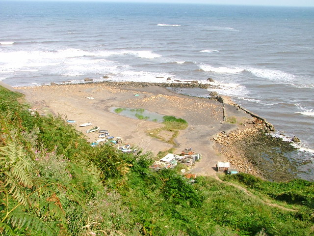
English: Port Mulgrave Harbour. An almost identical picture to the other undated one showing the recent filling of the harbour. I suspect this is deliberate to prevent erosion of what remains of the harbour. There now is a pond with bullrushes in.
Port Mulgrave owes its existence to the ironstone industry. The blocked up mine entrance can still be seen 50' above high water above what remains of the harbour. Tunnelling began in 1854 and work on the harbour had started two years later. By the 1870's new more productive seams were found three miles away at the secluded valley of Easington Beck in Grinkle Park. The only feasible method of transporting the stone out was by sea and so the original tunnel at Port Mulgrave was extended for a further mile to connect to the Grinkle Park mine. Gradually the Port Mulgrave mine itself was abandoned but the harbour continued to be used for Grinkle Park ore until 1917 when a connection was made to the Middlesbrough to Whitby railway owing to the wartime dangers to shipping. The machinery at the harbour was finally dismantled in 1934 during which the wooden gantry accidentally caught fire. Later the Royal Engineers destroyed the breakwater to prevent German forces using the place for an invasion. |
| Date | |
| Source | From geograph.org.uk |
| Author | Mick Garratt |
| Attribution (required by the license) | Mick Garratt / Port Mulgrave Harbour / |
| Object location | | View this and other nearby images on: OpenStreetMap |
|---|
_&language=en)
Licensing

|
This image was taken from the Geograph project collection. See this photograph's page on the Geograph website for the photographer's contact details. The copyright on this image is owned by Mick Garratt and is licensed for reuse under the Creative Commons Attribution-ShareAlike 2.0 license.
|
- You are free:
- to share – to copy, distribute and transmit the work
- to remix – to adapt the work
- Under the following conditions:
- attribution – You must give appropriate credit, provide a link to the license, and indicate if changes were made. You may do so in any reasonable manner, but not in any way that suggests the licensor endorses you or your use.
- share alike – If you remix, transform, or build upon the material, you must distribute your contributions under the same or compatible license as the original.
File history
Click on a date/time to view the file as it appeared at that time.
| Date/Time | Thumbnail | Dimensions | User | Comment | |
|---|---|---|---|---|---|
| current | 17:32, 30 January 2010 | | 640 × 480 (129 KB) | GeographBot | == {{int:filedesc}} == {{Information |description={{en|1=Port Mulgrave Harbour. An almost identical picture to the other undated one showing the recent filling of the harbour. I suspect this is deliberate to prevent erosion of what remains of the harbour. |