
File:Priory Corner, Isle of Portland - geograph.org.uk - 942666.jpg
No higher resolution available.
Priory_Corner,_Isle_of_Portland_-_geograph.org.uk_-_942666.jpg (640 × 480 pixels, file size: 78 KB, MIME type: image/jpeg)
| This is a file from the Wikimedia Commons. Information from its description page there is shown below. Commons is a freely licensed media file repository. You can help. |
Summary
| Description |
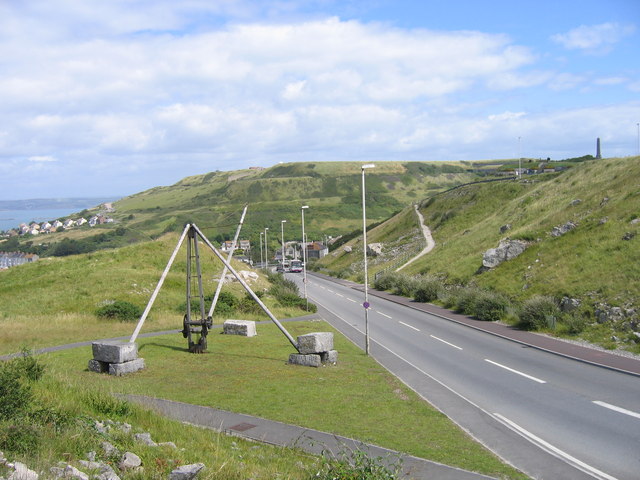
English: Priory Corner, Isle of Portland. From approximately where the bus is, New Road was diverted away from the cliff edge in 1996; there is a near-hairpin bend just out of shot to the right. At this point Portland stone brought out of the quarries in the north-west part of the Isle were transferred to the Merchants Tramway for onward passage to Castletown and shipment. The crane in the foreground was erected in 1997 to commemorate this exchange point. The tramway contoured along the hillside from the top of the buff path to the right of the road and is the lower step (immediately above the crane jib) across the Verne hill in the distance. At the white houses it descended a rope-worked incline to the harbour. The upper step below the summit marks the course of a dry vertical-walled "moat" around the prison inside the hill. |
||
| Date | |||
| Source | geograph.org.uk | ||
| Author | A-M-Jervis | ||
| Permission (Reusing this file) |
This file is licensed under the Creative Commons Attribution-Share Alike 2.0 Generic license. Attribution: A-M-Jervis
|
||
| Attribution (required by the license) | A-M-Jervis / Priory Corner, Isle of Portland / | ||

| Camera location | | View this and other nearby images on: OpenStreetMap |
|---|
_heading:45.00&language=en)
| Object location | | View this and other nearby images on: OpenStreetMap |
|---|
_heading:45.00&language=en)
File history
Click on a date/time to view the file as it appeared at that time.
| Date/Time | Thumbnail | Dimensions | User | Comment | |
|---|---|---|---|---|---|
| current | 10:42, 22 February 2011 | | 640 × 480 (78 KB) | GeographBot | == {{int:filedesc}} == {{Information |description={{en|1=Priory Corner, Isle of Portland From approximately where the bus is, New Road was diverted away from the cliff edge in 1996; there is a near-hairpin bend just out of shot to the right. At this poin |
File usage
The following pages on the English Wikipedia use this file (pages on other projects are not listed):