
File:Railway incline - geograph.org.uk - 70922.jpg
No higher resolution available.
Railway_incline_-_geograph.org.uk_-_70922.jpg (640 × 480 pixels, file size: 68 KB, MIME type: image/jpeg)
| This is a file from the Wikimedia Commons. Information from its description page there is shown below. Commons is a freely licensed media file repository. You can help. |
Summary
| Description |
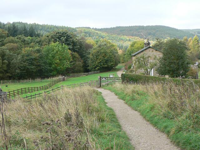
English: Railway incline. The path follows the original line of the Whitby-Pickering railway, opened in 1836. At first the carriages were pulled by horses, and a cable system was used to haul carriages up and down this 1-in-15 incline. Nine years later the line was converted for steam locomotives, and new section was built to bypass this incline. Looking SW to Incline Cottage. |
| Date | |
| Source | From geograph.org.uk |
| Author | Rob Burke |
| Attribution (required by the license) | Rob Burke / Railway incline / |
| Object location | | View this and other nearby images on: OpenStreetMap |
|---|
_&language=en)
Licensing

|
This image was taken from the Geograph project collection. See this photograph's page on the Geograph website for the photographer's contact details. The copyright on this image is owned by Rob Burke and is licensed for reuse under the Creative Commons Attribution-ShareAlike 2.0 license.
|
This file is licensed under the Creative Commons Attribution-Share Alike 2.0 Generic license.
Attribution: Rob Burke
- You are free:
- to share – to copy, distribute and transmit the work
- to remix – to adapt the work
- Under the following conditions:
- attribution – You must give appropriate credit, provide a link to the license, and indicate if changes were made. You may do so in any reasonable manner, but not in any way that suggests the licensor endorses you or your use.
- share alike – If you remix, transform, or build upon the material, you must distribute your contributions under the same or compatible license as the original.
File history
Click on a date/time to view the file as it appeared at that time.
| Date/Time | Thumbnail | Dimensions | User | Comment | |
|---|---|---|---|---|---|
| current | 18:19, 30 January 2010 | | 640 × 480 (68 KB) | GeographBot | == {{int:filedesc}} == {{Information |description={{en|1=Railway incline. The path follows the original line of the Whitby-Pickering railway, opened in 1836. At first the carriages were pulled by horses, and a cable system was used to haul carriages up an |
File usage
The following pages on the English Wikipedia use this file (pages on other projects are not listed):