
File:Roma quadrata - Palatina, Vierregionenstadt und Servianische Stadt.jpg

Size of this preview: 551 × 599 pixels. Other resolutions: 221 × 240 pixels | 441 × 480 pixels | 706 × 768 pixels | 942 × 1,024 pixels | 1,600 × 1,740 pixels.
Original file (1,600 × 1,740 pixels, file size: 1.26 MB, MIME type: image/jpeg)
| This is a file from the Wikimedia Commons. Information from its description page there is shown below. Commons is a freely licensed media file repository. You can help. |
Summary
| Description |
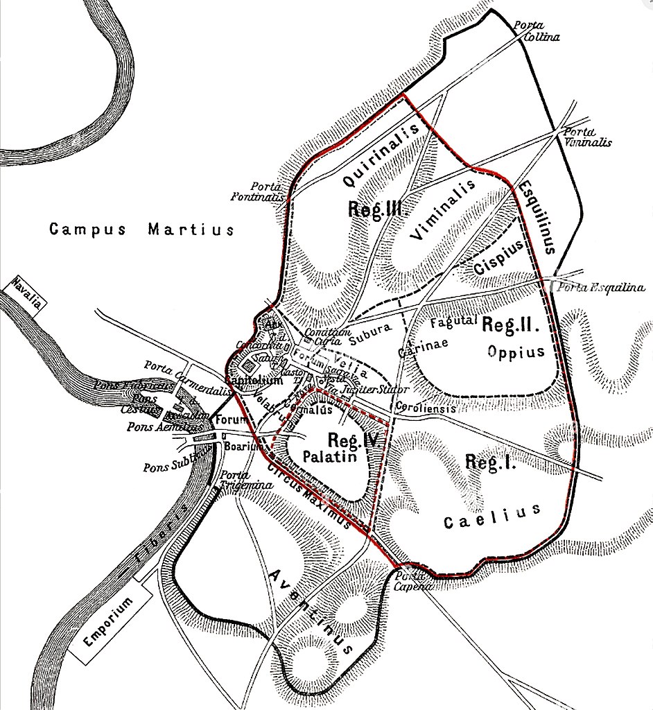
English: A map based on the plan in Müller’s Handbuch der Klassischen Altertumswissenschaft ("Handbook of Classical Studies"), showing a conjectural boundary for the original pomerium of the archaic city on the Palatine Hill ("Roma Quadrata") credited to Romulus and the Republican walls later credited to King Servius with its four regions. The plan ignores Tacitus's claimed extension of the city's territory to include the Altar of Hercules in the Forum Boarium between the Palatine and Aventine.
Français : Roma quadrata – Palatina, ville des quatre régions et ville de Servian. D’après le plan de la Handbuch der klassischen Altertumswissenschaft (Manuel d’études classiques). Avec le pomerium d’origine.
Deutsch: Roma quadrata – Palatina, Vierregionenstadt und Servianische Stadt. Aufbauend auf dem Plan in Müllers Handbuch der klassischen Altertumswissenschaft. Mit dem ursprünglichen pomerium. |
| Date | |
| Source | https://www.alamy.de/roma-quadrata-die-ursprungliche-pomerium-der-antiken-stadt-rom-image182932661.html |
| Author | Unknown author |
Licensing
|
This work is in the public domain in its country of origin and other countries and areas where the copyright term is the author's life plus 100 years or fewer. This work is in the public domain in the United States because it was published (or registered with the U.S. Copyright Office) before January 1, 1929. | |
| This file has been identified as being free of known restrictions under copyright law, including all related and neighboring rights. | |
File history
Click on a date/time to view the file as it appeared at that time.
| Date/Time | Thumbnail | Dimensions | User | Comment | |
|---|---|---|---|---|---|
| current | 13:36, 23 September 2022 | | 1,600 × 1,740 (1.26 MB) | Waterborough | {{Information |Description= {{de|Roma quadrata – Palatina, Vierregionenstadt und Servianische Stadt. Aufbauend auf dem Plan in Müllers ''Handbuch der klassischen Altertumswissenschaft''.}} {{en|Roma quadrata – Palatina, four-regional city and Servian city. Based on the plan in Müller’s ''Handbuch der klassischen Altertumswissenschaft'' (Handbook of Classical Studies).}} {{fr|Roma quadrata – Palatina, ville des quatre régions et ville de Servian. D’après le plan de la ''Handbuch der klassische... |
File usage
The following pages on the English Wikipedia use this file (pages on other projects are not listed):
Global file usage
The following other wikis use this file:
- Usage on ca.wikipedia.org
- Usage on de.wikipedia.org
- Usage on es.wikipedia.org
- Usage on www.wikidata.org