
File:Ruínas do Castelo de Moura - Portugal (8235886036).jpg
Original file (5,699 × 3,800 pixels, file size: 4.57 MB, MIME type: image/jpeg)
| This is a file from the Wikimedia Commons. Information from its description page there is shown below. Commons is a freely licensed media file repository. You can help. |
.jpg)
Summary
| Description |
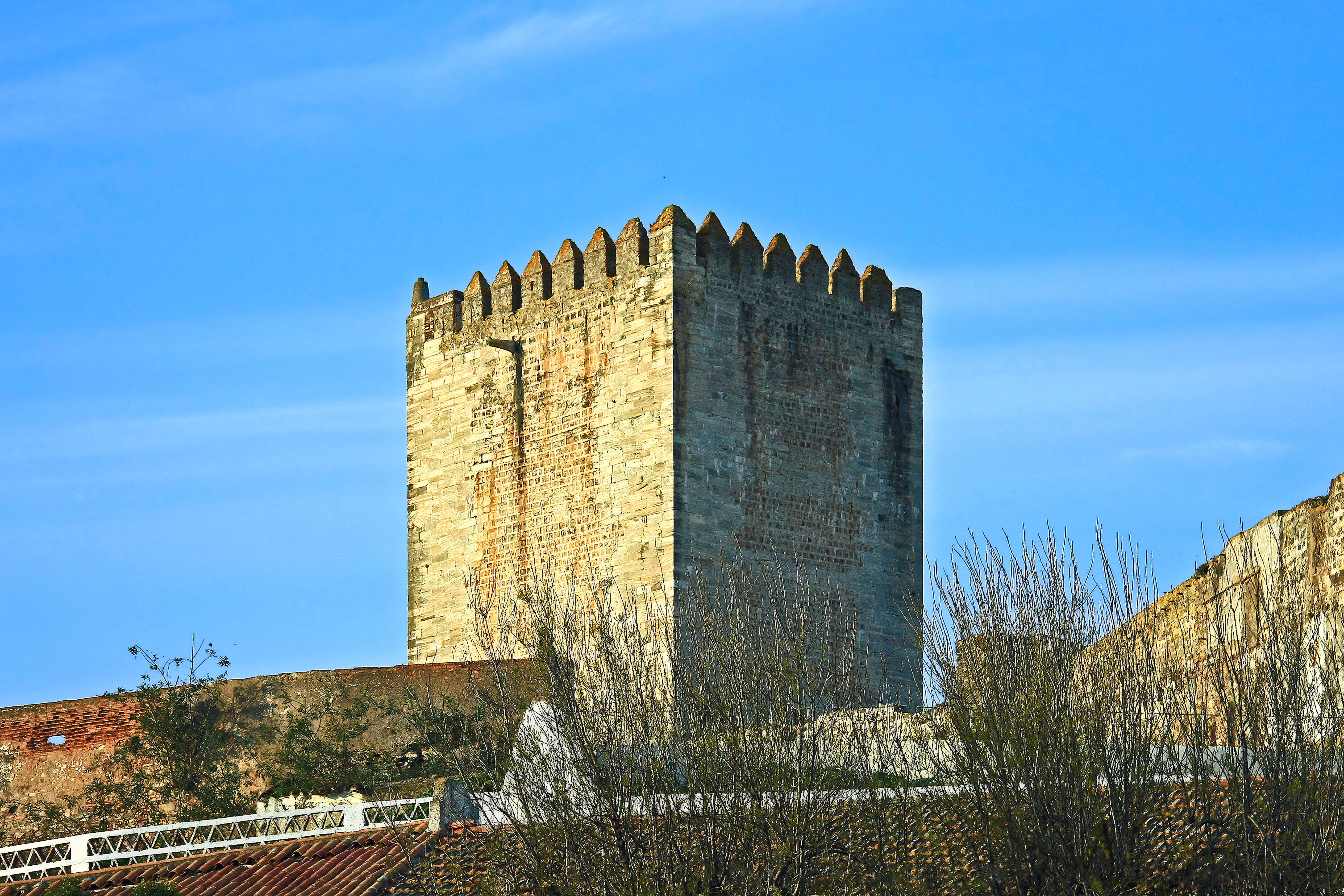
Dominando a cidade com o que resta das suas torres e muralhas, o castelo de Moura foi construído pelos portugueses no início do séc. XIV aproveitando as fortificações deixadas pelos árabes. Na segunda metade deste século foi-lhe acrescentada uma segunda cerca muralhada para abrigar a população que aumentava. No séc. XVI, D. Manuel I encarregou o arquitecto Francisco de Arruda de proceder a algumas alterações, em que se incluem provavelmente a torre do relógio, datando também desta época o convento feminino de S. Domingos, que se encontra no interior da cerca, mandado erguer por D. Ângela de Moura, em 1562, sobre as fundações da antiga mesquita. A igreja conventual guarda o túmulo manuelino dos irmãos Pedro e Álvaro Rodrigues, presumíveis conquistadores de Moura. Durante as Guerras da Restauração, na segunda metade do séc. XVII, a fortaleza medieval foi reforçada com uma linha de baluartes e revelins, segundo o projecto de Nicolau de Langres, adaptada às novas técnicas de guerra com armas de fogo. Do conjunto fortificado destacam-se a torre de menagem rectangular e uma torre circular sobre a qual se acrescentou um relógio no séc. XIX. <a href="http://www.visitportugal.com/NR/exeres/91EAFB7A-5E0E-4276-BD24-976024EAE784,frameless.htm" rel="nofollow">www.visitportugal.com/NR/exeres/91EAFB7A-5E0E-4276-BD24-9...</a> Dominating the town with what remains of its towers and walls, Moura castle was built by the Portuguese at the beginning of the 14th century, taking advantage of the fortifications left behind by the Arabs. In the second half of this same century, a second walled enclosure was added to provide shelter for the growing population. In the 16th century, D. Manuel I commissioned Francisco de Arruda to make some alterations, which probably included the clock tower. Also dating from this time was the convent of São Domingos, built within the walled enclosure at the orders of D. Ângela de Moura, in 1562, upon the foundations of the former mosque. The convent church contains the Manueline tomb of the brothers Pedro and Álvaro Rodrigues, the presumed conquerors of Moura. During the Wars of Restoration of Portugal from Spain, in the second half of the 17th century, the mediaeval fortress was strengthened with a line of bulwarks and ravelins, in keeping with the project developed by Nicolau de Langres, and adapted to withstand the new fighting techniques involving the use of firearms. Amongst the various fortifications, the most prominent feature is the sturdy-looking rectangular keep and a circular tower onto which a clock was added in the 19th century. <a href="http://www.visitportugal.com/NR/exeres/91EAFB7A-5E0E-4276-BD24-976024EAE784,frameless.htm" rel="nofollow">www.visitportugal.com/NR/exeres/91EAFB7A-5E0E-4276-BD24-9...</a> <a href="http://loc.alize.us/#/flickr:8235886036" rel="nofollow">See where this picture was taken.</a> <a href="https://www.flickr.com/groups/geotagging/discuss/72157594165549916/">[?]</a> |
| Date | |
| Source | Ruínas do Castelo de Moura - Portugal |
| Author | Vitor Oliveira from Torres Vedras, PORTUGAL |
| Camera location | | View this and other nearby images on: OpenStreetMap |
|---|
.jpg¶ms=038.142960_N_-007.451491_E_globe:Earth_type:camera_source:Flickr_&language=en)
Licensing
- You are free:
- to share – to copy, distribute and transmit the work
- to remix – to adapt the work
- Under the following conditions:
- attribution – You must give appropriate credit, provide a link to the license, and indicate if changes were made. You may do so in any reasonable manner, but not in any way that suggests the licensor endorses you or your use.
- share alike – If you remix, transform, or build upon the material, you must distribute your contributions under the same or compatible license as the original.
| This image was originally posted to Flickr by Portuguese_eyes at https://flickr.com/photos/21446942@N00/8235886036 (archive). It was reviewed on 15 April 2019 by FlickreviewR 2 and was confirmed to be licensed under the terms of the cc-by-sa-2.0. |
File history
Click on a date/time to view the file as it appeared at that time.
| Date/Time | Thumbnail | Dimensions | User | Comment | |
|---|---|---|---|---|---|
| current | 14:46, 20 May 2024 | | 5,699 × 3,800 (4.57 MB) | ReneeWrites | Removed watermark, perspective correction |
| 04:52, 15 April 2019 |  | 5,699 × 3,800 (4.84 MB) | Tm | Transferred from Flickr via #flickr2commons |
File usage
Global file usage
The following other wikis use this file:
- Usage on es.wikipedia.org
- Usage on gl.wikipedia.org
- Usage on pt.wikipedia.org
- Usage on www.wikidata.org
.jpg)