
File:S-Bahn Berlin - Netzplan.svg

Size of this PNG preview of this SVG file: 800 × 596 pixels. Other resolutions: 320 × 238 pixels | 640 × 477 pixels | 1,024 × 763 pixels | 1,280 × 953 pixels | 2,560 × 1,907 pixels | 1,830 × 1,363 pixels.
Original file (SVG file, nominally 1,830 × 1,363 pixels, file size: 1.21 MB)
| This is a file from the Wikimedia Commons. Information from its description page there is shown below. Commons is a freely licensed media file repository. You can help. |
Summary
| Description |
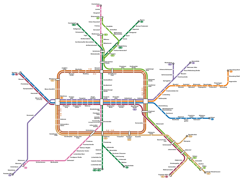
Deutsch: Netzplan der S-Bahn Berlin.
English: Map of the Berlin S-Bahn.
Italiano: Mappa della S-Bahn di Berlino. |
| Source | Own work |
| Author | Arbalete |
| Permission (Reusing this file) |
I, the copyright holder of this work, hereby publish it under the following license: This file is licensed under the Creative Commons Attribution-Share Alike 4.0 International license.
|
| Other versions |
|

File history
Click on a date/time to view the file as it appeared at that time.
| Date/Time | Thumbnail | Dimensions | User | Comment | |
|---|---|---|---|---|---|
| current | 16:59, 11 December 2023 | | 1,830 × 1,363 (1.21 MB) | NordNordWest | upd 2023 |
| 17:17, 30 May 2023 |  | 1,830 × 1,363 (1.82 MB) | Adrio | "S 5" an Westkreuz war noch eckig, an Änderung von KarlBeecken angepasst | |
| 21:39, 30 April 2023 |  | 1,830 × 1,363 (1.82 MB) | Felicior | change border radius of line symbols to resemble the actual line symbols | |
| 00:50, 19 April 2023 |  | 1,830 × 1,363 (1.82 MB) | Adrio | Stand 11.12.2022; Updates: S8 bis Wildau, S75 nur noch bis Warschauer Straße; Yorckstraße aufgeteilt | |
| 12:32, 23 June 2022 |  | 1,830 × 1,363 (1.89 MB) | Arbalete | Kleine Korrektur | |
| 22:01, 8 May 2022 |  | 1,830 × 1,363 (1.86 MB) | Arbalete | Update | |
| 21:41, 29 October 2020 |  | 1,005 × 795 (2.12 MB) | Arbalete | Update | |
| 16:54, 15 March 2019 |  | 1,005 × 795 (2.08 MB) | Arbalete | Korrektur | |
| 15:30, 6 January 2018 |  | 1,005 × 795 (2.01 MB) | Arbalete | Kleine Korrektur | |
| 15:28, 6 January 2018 |  | 1,005 × 795 (1.89 MB) | Arbalete | Kleine Korrektur |
File usage
The following pages on the English Wikipedia use this file (pages on other projects are not listed):
Global file usage
The following other wikis use this file:
- Usage on ar.wikipedia.org
- Usage on de.wikipedia.org
- Usage on et.wikipedia.org
- Usage on fi.wikipedia.org
- Usage on hu.wikipedia.org
- Usage on ie.wikipedia.org
- Usage on lv.wikipedia.org
- Usage on ur.wikipedia.org
- Usage on www.wikidata.org
- Usage on zh.wikipedia.org