
File:Sherburn Colliery - geograph-3242674-by-Dean-Molyneaux.jpg
Sherburn_Colliery_-_geograph-3242674-by-Dean-Molyneaux.jpg (640 × 480 pixels, file size: 101 KB, MIME type: image/jpeg)
| This is a file from the Wikimedia Commons. Information from its description page there is shown below. Commons is a freely licensed media file repository. You can help. |
Summary
| Description |
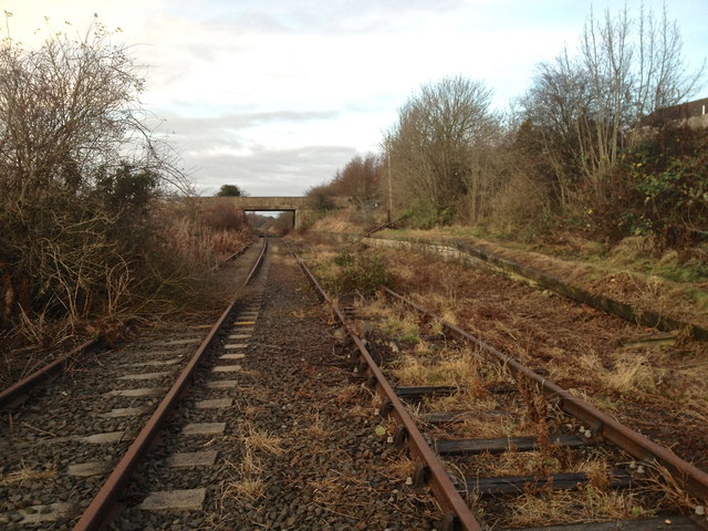
English: Former goods dock at Sherburn Colliery station This is the Leamside Line, which previously linked the East Coast Mainline south of Durham with Heworth in Gateshead, passing through Washington. Passenger services were withdrawn on this section of the line in 1941. It remained for freight use only (as a 'Mineral Railway' for coal). It had served as the East Coast line until 1872, when it was diverted to the west of Durham city. This section, south of what once was Sherburn Colliery station (the main body of the station lay to the north of the bridge in the distance) is due to have the tracks lifted imminently. Trees and vegetation have been removed from the line in anticipation of this work. The trackbed is not to be sold and all plans to reinstate the line have been deferred until at least 2019. The line was first opened in 1839. The platform to the right is the only evidence of Sherburn Colliery station that remains. It was used as a goods dock. |
| Date | |
| Source | From geograph.org.uk |
| Author | Dean Molyneaux |
| Permission (Reusing this file) |
Creative Commons Attribution Share-alike license 2.0 |
| Attribution (required by the license) | Dean Molyneaux / Former goods dock at Sherburn Colliery station / |
| Object location | | View this and other nearby images on: OpenStreetMap |
|---|
_heading:67.00&language=en)
Licensing

|
This image was taken from the Geograph project collection. See this photograph's page on the Geograph website for the photographer's contact details. The copyright on this image is owned by Dean Molyneaux and is licensed for reuse under the Creative Commons Attribution-ShareAlike 2.0 license.
|
- You are free:
- to share – to copy, distribute and transmit the work
- to remix – to adapt the work
- Under the following conditions:
- attribution – You must give appropriate credit, provide a link to the license, and indicate if changes were made. You may do so in any reasonable manner, but not in any way that suggests the licensor endorses you or your use.
- share alike – If you remix, transform, or build upon the material, you must distribute your contributions under the same or compatible license as the original.
File history
Click on a date/time to view the file as it appeared at that time.
| Date/Time | Thumbnail | Dimensions | User | Comment | |
|---|---|---|---|---|---|
| current | 16:27, 19 December 2020 | | 640 × 480 (101 KB) | Lamberhurst | == {{int:filedesc}} == {{Information |Description={{en|1=<b>Former goods dock at Sherburn Colliery station</b><br>This is the Leamside Line, which previously linked the East Coast Mainline south of Durham with Heworth in Gateshead, passing through Washington. Passenger services were withdrawn on this section of the line in 1941. It remained for freight use only (as a 'Mineral Railway' for coal). It had served as the East Coast line until 1872, when it was diverted to the west of Durham city.... |