
File:Silhill Hall Site - geograph.org.uk - 1325740.jpg
No higher resolution available.
Silhill_Hall_Site_-_geograph.org.uk_-_1325740.jpg (640 × 480 pixels, file size: 60 KB, MIME type: image/jpeg)
| This is a file from the Wikimedia Commons. Information from its description page there is shown below. Commons is a freely licensed media file repository. You can help. |
Summary
| Description |
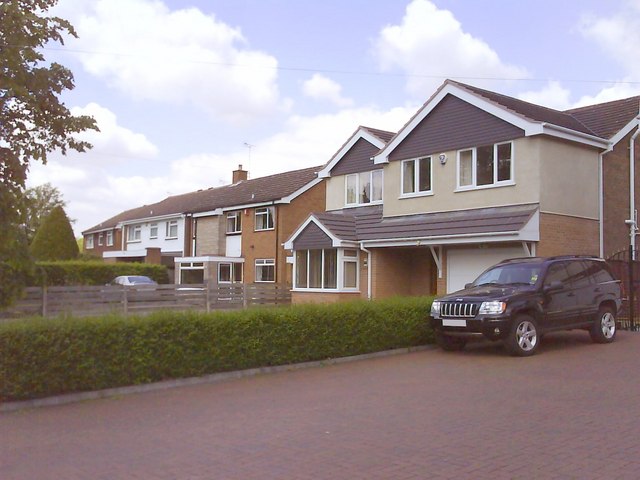
English: Silhill Hall Site Some of the six houses that are now built on the site of the old Silhill Hall.
Silhill Hall (also known as Solihull Hall) was demolished illegally in the spring of 1966, the owner using the unsatisfactory excuse that a violent storm had made the structure unsafe. As the oldest domestic building in the borough, dating back to the 13th-14th centuries, its destruction was a great loss. Pevsner's Warwickshire, published in 1966 just before the demolition, describes both Soane's gatehouse and Silhill Hall on p. 402 and includes a photo of the gatehouse. There are two photos of Silhill Hall in a book by Susan Bell, Joy Woodhouse and Molly Varley "Solihull as it was" published by Solihull Libraries in 1980. |
| Date | |
| Source | From geograph.org.uk |
| Author | Graham Butcher |
| Attribution (required by the license) | Graham Butcher / Silhill Hall Site / |
| Camera location | | View this and other nearby images on: OpenStreetMap |
|---|
_heading:315.00&language=en)
| Object location | | View this and other nearby images on: OpenStreetMap |
|---|
_heading:315.00&language=en)
Licensing

|
This image was taken from the Geograph project collection. See this photograph's page on the Geograph website for the photographer's contact details. The copyright on this image is owned by Graham Butcher and is licensed for reuse under the Creative Commons Attribution-ShareAlike 2.0 license.
|
This file is licensed under the Creative Commons Attribution-Share Alike 2.0 Generic license.
Attribution: Graham Butcher
- You are free:
- to share – to copy, distribute and transmit the work
- to remix – to adapt the work
- Under the following conditions:
- attribution – You must give appropriate credit, provide a link to the license, and indicate if changes were made. You may do so in any reasonable manner, but not in any way that suggests the licensor endorses you or your use.
- share alike – If you remix, transform, or build upon the material, you must distribute your contributions under the same or compatible license as the original.

|
The categories of this image need checking. You can do so here.
|
File history
Click on a date/time to view the file as it appeared at that time.
| Date/Time | Thumbnail | Dimensions | User | Comment | |
|---|---|---|---|---|---|
| current | 22:39, 27 February 2011 | | 640 × 480 (60 KB) | GeographBot | == {{int:filedesc}} == {{Information |description={{en|1=Silhill Hall Site Some of the six houses that are now built on the site of the old Silhill Hall. Silhill Hall (also known as Solihull Hall) was demolished illegally in the spring of 1966, the own |
File usage
The following pages on the English Wikipedia use this file (pages on other projects are not listed):