
File:South Elevation - Salubria, Salubria Lane, Stevensburg, Culpeper County, VA.jpg

Size of this preview: 800 × 585 pixels. Other resolutions: 320 × 234 pixels | 640 × 468 pixels | 1,024 × 749 pixels.
Original file (1,024 × 749 pixels, file size: 375 KB, MIME type: image/jpeg)
| This is a file from the Wikimedia Commons. Information from its description page there is shown below. Commons is a freely licensed media file repository. You can help. |
Summary
| Author |
Library of Congress Prints and Photographs Division Washington, D.C. 20540 USA |
|||
| Description |
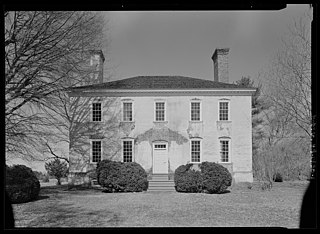
English: Memorial Foundation of the Germanna Colonies in Virginia; Thompson, John; Spotswood, Butler Brayne; Barbour, Mordecai; Hansbrough, James; Grayson, Cary T; Arzola, Robert, architect; Dolinsky, Paul, Chief, Historic American Landscapes Survey; Stoyko, Greta, field team; Stoyko, Greta, delineator |
|||
| Depicted place | Virginia; Culpeper County; Stevensburg | |||
| Date | Documentation compiled after 1933 | |||
| Current location |
Library of Congress Prints and Photographs Division Washington, D.C. 20540 USA http://hdl.loc.gov/loc.pnp/pp.print |
|||
| Accession number |
HABS VA-1430-1 |
|||
| Credit line |
|
|||
| Notes |
|
|||
| Source | https://www.loc.gov/pictures/item/va2094/ | |||
| Permission (Reusing this file) |
|

| Camera location | | View this and other nearby images on: OpenStreetMap |
|---|
Licensing
This work is in the public domain in the United States because it is a work prepared by an officer or employee of the United States Government as part of that person’s official duties under the terms of Title 17, Chapter 1, Section 105 of the US Code.
Note: This only applies to original works of the Federal Government and not to the work of any individual U.S. state, territory, commonwealth, county, municipality, or any other subdivision. This template also does not apply to postage stamp designs published by the United States Postal Service since 1978. (See § 313.6(C)(1) of Compendium of U.S. Copyright Office Practices). It also does not apply to certain US coins; see The US Mint Terms of Use.
|
 | |
| This file has been identified as being free of known restrictions under copyright law, including all related and neighboring rights. | ||
File history
Click on a date/time to view the file as it appeared at that time.
| Date/Time | Thumbnail | Dimensions | User | Comment | |
|---|---|---|---|---|---|
| current | 18:27, 1 April 2016 | | 1,024 × 749 (375 KB) | KMJKWhite | User created page with UploadWizard |
File usage
The following pages on the English Wikipedia use this file (pages on other projects are not listed):
Global file usage
The following other wikis use this file:
- Usage on www.wikidata.org