
File:Southminster railway station, 2011.jpg

Size of this preview: 800 × 565 pixels. Other resolutions: 320 × 226 pixels | 640 × 452 pixels | 1,024 × 723 pixels | 1,280 × 904 pixels | 2,560 × 1,809 pixels | 3,567 × 2,520 pixels.
Original file (3,567 × 2,520 pixels, file size: 2.72 MB, MIME type: image/jpeg)
| This is a file from the Wikimedia Commons. Information from its description page there is shown below. Commons is a freely licensed media file repository. You can help. |
Summary
| Description |
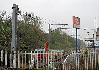
English: A view of the end of the line at Southminster railway station. The term "catenary" is used for overhead lines which use at least 2 wires, with the contact wire being held in tension almost parallel to the track; this picture gives a clear view of the line tensioning weights on the post closest to the camera. Southminster station was opened by the Great Eastern Railway in 1889. It is now the terminus of the Crouch Valley Line, trains go to Wickford and occasionally through to London Liverpool Street. |
| Date | |
| Source | From geograph.org.uk |
| Author | Roger Jones |
| Attribution (required by the license) | Roger Jones / Catenary tensioning weights at the end of the line / |
| Camera location | | View this and other nearby images on: OpenStreetMap |
|---|
_heading:157.00&language=en)
| Object location | | View this and other nearby images on: OpenStreetMap |
|---|
_heading:157.00&language=en)
Licensing

|
This image was taken from the Geograph project collection. See this photograph's page on the Geograph website for the photographer's contact details. The copyright on this image is owned by Roger Jones and is licensed for reuse under the Creative Commons Attribution-ShareAlike 2.0 license.
|
This file is licensed under the Creative Commons Attribution-Share Alike 2.0 Generic license.
Attribution: Roger Jones
- You are free:
- to share – to copy, distribute and transmit the work
- to remix – to adapt the work
- Under the following conditions:
- attribution – You must give appropriate credit, provide a link to the license, and indicate if changes were made. You may do so in any reasonable manner, but not in any way that suggests the licensor endorses you or your use.
- share alike – If you remix, transform, or build upon the material, you must distribute your contributions under the same or compatible license as the original.
File history
Click on a date/time to view the file as it appeared at that time.
| Date/Time | Thumbnail | Dimensions | User | Comment | |
|---|---|---|---|---|---|
| current | 23:36, 25 January 2018 | | 3,567 × 2,520 (2.72 MB) | Bjh21 | Higher-resolution version from Geograph |
| 19:01, 11 November 2017 |  | 640 × 452 (111 KB) | Tbmurray | User created page with UploadWizard |
File usage
The following pages on the English Wikipedia use this file (pages on other projects are not listed):