
File:Spuyten.jpg

Size of this preview: 748 × 600 pixels. Other resolutions: 299 × 240 pixels | 599 × 480 pixels | 798 × 640 pixels.
Original file (798 × 640 pixels, file size: 91 KB, MIME type: image/jpeg)
| This is a file from the Wikimedia Commons. Information from its description page there is shown below. Commons is a freely licensed media file repository. You can help. |
Summary
| Description |
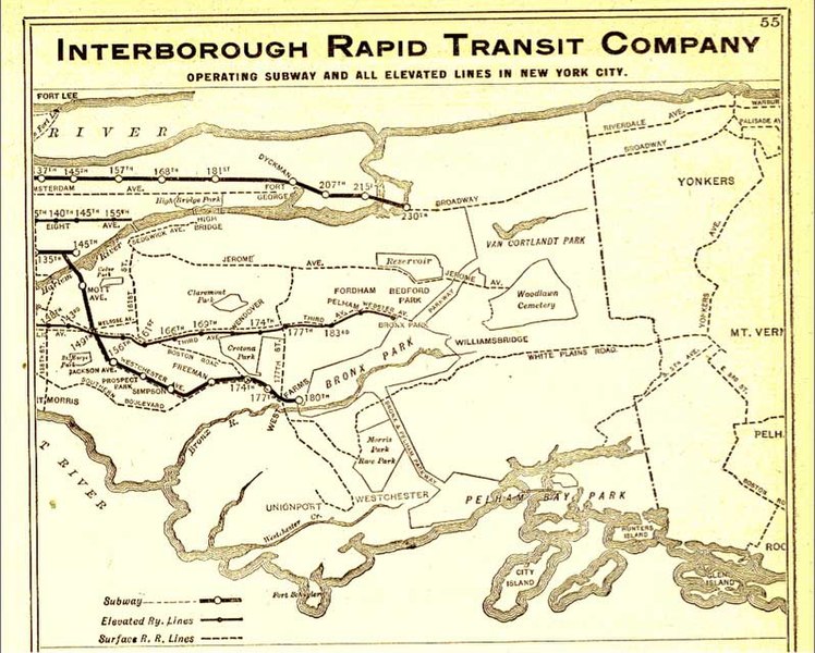
English: This is an IRT map from 1906. Notice how Marble Hill is surrounded by a small waterway, which was eventually filled in to physically attach Marble Hill to the Bronx. (Note that this map is oriented with North to the right, and West at the top.) |
| Date | |
| Source | www.nycsubway.org; scanned from the Official Guide of the Railways, Nov. 1906. |
| Author | Interborough Rapid Transit Company |
| Other versions | File:Spuyten Duyvil IRT map.jpg |
Licensing
|
This is a faithful photographic reproduction of a two-dimensional, public domain work of art. The work of art itself is in the public domain for the following reason:
The official position taken by the Wikimedia Foundation is that "faithful reproductions of two-dimensional public domain works of art are public domain".
This photographic reproduction is therefore also considered to be in the public domain in the United States. In other jurisdictions, re-use of this content may be restricted; see Reuse of PD-Art photographs for details. |
Original upload log
The original description page was here. All following user names refer to en.wikipedia.
| Date/Time | Dimensions | User | Comment |
|---|---|---|---|
| 2006-04-08 23:49 | 798×640× (92755 bytes) | Spiro541 | This is an IRT map from the early 1900s. Notice how Marble Hill is surrounded by a small waterway, which was eventually filled in to physically attach Marble Hill to the Bronx. |
File history
Click on a date/time to view the file as it appeared at that time.
| Date/Time | Thumbnail | Dimensions | User | Comment | |
|---|---|---|---|---|---|
| current | 01:53, 4 July 2016 | | 798 × 640 (91 KB) | Renamed user mou89p43twvqcvm8ut9w3 | Transferred from en.wikipedia |
File usage
No pages on the English Wikipedia use this file (pages on other projects are not listed).