
File:St. Mary and All Saints Parish Church - geograph.org.uk - 1346350.jpg
No higher resolution available.
St._Mary_and_All_Saints_Parish_Church_-_geograph.org.uk_-_1346350.jpg (640 × 484 pixels, file size: 73 KB, MIME type: image/jpeg)
| This is a file from the Wikimedia Commons. Information from its description page there is shown below. Commons is a freely licensed media file repository. You can help. |
Summary
| Description |
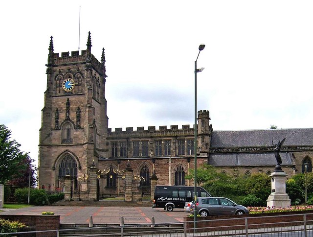
English: St. Mary & All Saints Parish Church The largest parish church in Worcestershire, and thought to date from the 15th/16th centuries, but much is Victorian, when the church underwent major restoration. There was an earlier church, which the current church either incorporates part of, or is on the site of. There used to be a large open space in front of the church, at the end of Church Street, but it was sacrificed to make way for the ring road, which now runs in front of the church.
The statue in the church grounds, on the right, is a war memorial. 1021544 |
| Date | |
| Source | From geograph.org.uk |
| Author | P L Chadwick |
| Attribution (required by the license) | P L Chadwick / St. Mary & All Saints Parish Church / |
| Camera location | | View this and other nearby images on: OpenStreetMap |
|---|
_heading:337.00&language=en)
| Object location | | View this and other nearby images on: OpenStreetMap |
|---|
_heading:337.00&language=en)
Licensing

|
This image was taken from the Geograph project collection. See this photograph's page on the Geograph website for the photographer's contact details. The copyright on this image is owned by P L Chadwick and is licensed for reuse under the Creative Commons Attribution-ShareAlike 2.0 license.
|
This file is licensed under the Creative Commons Attribution-Share Alike 2.0 Generic license.
Attribution: P L Chadwick
- You are free:
- to share – to copy, distribute and transmit the work
- to remix – to adapt the work
- Under the following conditions:
- attribution – You must give appropriate credit, provide a link to the license, and indicate if changes were made. You may do so in any reasonable manner, but not in any way that suggests the licensor endorses you or your use.
- share alike – If you remix, transform, or build upon the material, you must distribute your contributions under the same or compatible license as the original.
File history
Click on a date/time to view the file as it appeared at that time.
| Date/Time | Thumbnail | Dimensions | User | Comment | |
|---|---|---|---|---|---|
| current | 05:39, 28 February 2011 | | 640 × 484 (73 KB) | GeographBot | == {{int:filedesc}} == {{Information |description={{en|1=St. Mary & All Saints Parish Church The largest parish church in Worcestershire, and thought to date from the 15th/16th centuries, but much is Victorian, when the church underwent major restoration. |
File usage
The following pages on the English Wikipedia use this file (pages on other projects are not listed):
Global file usage
The following other wikis use this file:
- Usage on arz.wikipedia.org
- Usage on dag.wikipedia.org
- Usage on www.wikidata.org