
File:St Helen, Mareham-le-Fen - geograph.org.uk - 105510.jpg
No higher resolution available.
St_Helen,_Mareham-le-Fen_-_geograph.org.uk_-_105510.jpg (640 × 480 pixels, file size: 99 KB, MIME type: image/jpeg)
| This is a file from the Wikimedia Commons. Information from its description page there is shown below. Commons is a freely licensed media file repository. You can help. |
Summary
| Description |
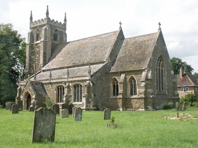
English: St Helen, Mareham-le-Fen. The earliest parts of the church date from about 1270 and they are the lower part of the tower and the tower arch. The church was largely restored in the 1870s, when the 14th-century chancel was almost entirely rebuilt. Further restoration work was done in the late 1960s and early 1970s. When the Mediaeval church of St Margaret, Old Woodhall was demolished, much of the material was brought over to build the new north vestry, kitchenette and vestibule. The font dates from the 14th-century, but the cover is modern. The registers were begun in 1558. The James Roberts gravestone, near the north door, was brought into the church to avoid further erosion. It commemorates the first voyage around the world under Captain James Cook. The famous botanist Joseph Banks from nearby Revesby was also aboard. |
| Date | |
| Source | From geograph.org.uk |
| Author | Dave Hitchborne |
| Attribution (required by the license) | Dave Hitchborne / St Helen, Mareham-le-Fen / |
| Camera location | | View this and other nearby images on: OpenStreetMap |
|---|
_&language=en)
| Object location | | View this and other nearby images on: OpenStreetMap |
|---|
_&language=en)
Licensing

|
This image was taken from the Geograph project collection. See this photograph's page on the Geograph website for the photographer's contact details. The copyright on this image is owned by Dave Hitchborne and is licensed for reuse under the Creative Commons Attribution-ShareAlike 2.0 license.
|
This file is licensed under the Creative Commons Attribution-Share Alike 2.0 Generic license.
Attribution: Dave Hitchborne
- You are free:
- to share – to copy, distribute and transmit the work
- to remix – to adapt the work
- Under the following conditions:
- attribution – You must give appropriate credit, provide a link to the license, and indicate if changes were made. You may do so in any reasonable manner, but not in any way that suggests the licensor endorses you or your use.
- share alike – If you remix, transform, or build upon the material, you must distribute your contributions under the same or compatible license as the original.
File history
Click on a date/time to view the file as it appeared at that time.
| Date/Time | Thumbnail | Dimensions | User | Comment | |
|---|---|---|---|---|---|
| current | 01:52, 31 January 2010 | | 640 × 480 (99 KB) | GeographBot | == {{int:filedesc}} == {{Information |description={{en|1=St Helen, Mareham-le-Fen. The earliest parts of the church date from about 1270 and they are the lower part of the tower and the tower arch. The church was largely restored in the 1870s, when the 14 |
File usage
The following pages on the English Wikipedia use this file (pages on other projects are not listed):
Global file usage
The following other wikis use this file:
- Usage on ceb.wikipedia.org
- Usage on cy.wikipedia.org
- Usage on de.wikipedia.org
- Usage on es.wikipedia.org
- Usage on fa.wikipedia.org
- Usage on fr.wikipedia.org
- Usage on it.wikipedia.org
- Usage on lld.wikipedia.org
- Usage on pl.wikipedia.org
- Usage on www.wikidata.org