
File:Staines from the air.jpg
No higher resolution available.
Staines_from_the_air.jpg (640 × 480 pixels, file size: 268 KB, MIME type: image/jpeg)
| This is a file from the Wikimedia Commons. Information from its description page there is shown below. Commons is a freely licensed media file repository. You can help. |
Summary
| Description |
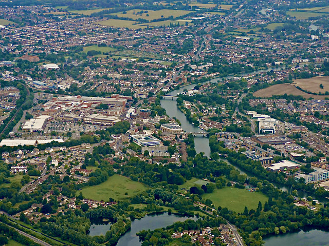
English: Staines-upon-Thames (left) and Egham Hythe (right) viewed from the west. Staines Bridge is the bridge nearest the camera and the railway bridge on the Staines-Reading line is in the distance. |
| Date | |
| Source | From geograph.org.uk |
| Author | Thomas Nugent |
| Permission (Reusing this file) |
Creative Commons Attribution Share-alike license 2.0 |
| Attribution (required by the license) | Thomas Nugent / Staines from the air / |
| Object location | | View this and other nearby images on: OpenStreetMap |
|---|
_heading:157.00&language=en)
Licensing

|
This image was taken from the Geograph project collection. See this photograph's page on the Geograph website for the photographer's contact details. The copyright on this image is owned by Thomas Nugent and is licensed for reuse under the Creative Commons Attribution-ShareAlike 2.0 license.
|
This file is licensed under the Creative Commons Attribution-Share Alike 2.0 Generic license.
Attribution: Thomas Nugent
- You are free:
- to share – to copy, distribute and transmit the work
- to remix – to adapt the work
- Under the following conditions:
- attribution – You must give appropriate credit, provide a link to the license, and indicate if changes were made. You may do so in any reasonable manner, but not in any way that suggests the licensor endorses you or your use.
- share alike – If you remix, transform, or build upon the material, you must distribute your contributions under the same or compatible license as the original.
File history
Click on a date/time to view the file as it appeared at that time.
| Date/Time | Thumbnail | Dimensions | User | Comment | |
|---|---|---|---|---|---|
| current | 07:14, 4 July 2022 | | 640 × 480 (268 KB) | Mertbiol | enhance colours |
| 20:03, 6 June 2022 |  | 640 × 480 (252 KB) | Mertbiol | enhance colours | |
| 19:58, 6 June 2022 |  | 640 × 480 (184 KB) | Mertbiol | Uploaded a work by Thomas Nugent from [https://www.geograph.org.uk/photo/4604899 geograph.org.uk] with UploadWizard |
File usage
The following pages on the English Wikipedia use this file (pages on other projects are not listed):
Global file usage
The following other wikis use this file:
- Usage on arz.wikipedia.org
- Usage on ca.wikipedia.org
- Usage on ceb.wikipedia.org
- Usage on cy.wikipedia.org
- Usage on en.wikivoyage.org
- Usage on es.wikipedia.org
- Usage on ga.wikipedia.org
- Usage on lld.wikipedia.org
- Usage on lv.wikipedia.org
- Usage on pl.wikipedia.org
- Usage on ro.wikipedia.org
- Usage on sr.wikipedia.org
- Usage on www.wikidata.org