
File:Symphyotrichum pilosum WISRs WetlandRegionsMap-2016.png
Size of this preview: 583 × 599 pixels. Other resolutions: 233 × 240 pixels | 467 × 480 pixels | 965 × 992 pixels.
Original file (965 × 992 pixels, file size: 657 KB, MIME type: image/png)
| This is a file from the Wikimedia Commons. Information from its description page there is shown below. Commons is a freely licensed media file repository. You can help. |
Summary
| Description |
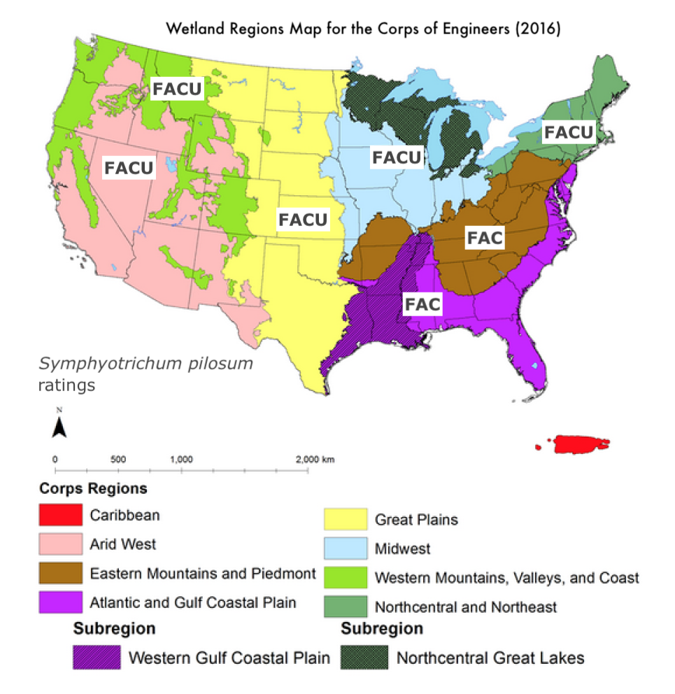
English: This is the 2016 US Army Corp of Engineers wetland regions map labeled with the 2020 wetland indicator statuses for Symphyotrichum pilosum. |
| Date | |
| Source |
This file was derived from: WetlandRegionsMap-2016.png:  |
| Author |
|
| This is a retouched picture, which means that it has been digitally altered from its original version. Modifications: Added text and trimmed url for original file location. The original can be viewed here: WetlandRegionsMap-2016.png:
|
Licensing
This work is in the public domain in the United States because it is a work prepared by an officer or employee of the United States Government as part of that person’s official duties under the terms of Title 17, Chapter 1, Section 105 of the US Code.
Note: This only applies to original works of the Federal Government and not to the work of any individual U.S. state, territory, commonwealth, county, municipality, or any other subdivision. This template also does not apply to postage stamp designs published by the United States Postal Service since 1978. (See § 313.6(C)(1) of Compendium of U.S. Copyright Office Practices). It also does not apply to certain US coins; see The US Mint Terms of Use.
|
 | |
| This file has been identified as being free of known restrictions under copyright law, including all related and neighboring rights. | ||
Original upload log
This image is a derivative work of the following images:
- File:WetlandRegionsMap-2016.png licensed with PD-USGov
- 2021-01-07T20:13:54Z Eewilson 965x1026 (678556 Bytes) Uploaded a work by R.W. Lichvar, D.L. Banks, W.N. Kirchner, and N.C. Melvin, in 2016 National Wetland Plant List, 12 May 2016, US Army Corp of Engineers, Engineer Research and Development Center, Cold Regions Research and Eng
Uploaded with derivativeFX
File history
Click on a date/time to view the file as it appeared at that time.
| Date/Time | Thumbnail | Dimensions | User | Comment | |
|---|---|---|---|---|---|
| current | 03:16, 8 November 2022 | | 965 × 992 (657 KB) | Eewilson | == {{int:filedesc}} == {{Information |Description={{en|1=Screenshot from p. 4 of the 2016 National Wetland Plant List publication (PDF), trimmed and modified with different text header and with location of original file at the bottom of the image.}} |date=2016-05-12 |Source={{Derived from|WetlandRegionsMap-2016.png|display=50}} |Date=2022-11-08 03:14 (UTC) |Author=* File:WetlandRegionsMap-2016.png: R.W. Lichvar, D.L. Banks, W.N. Kirchner, and N.C. Melvin,... |
File usage
The following pages on the English Wikipedia use this file (pages on other projects are not listed):