
File:Taiki eki.jpg

Size of this preview: 600 × 600 pixels. Other resolutions: 240 × 240 pixels | 480 × 480 pixels | 868 × 868 pixels.
Original file (868 × 868 pixels, file size: 700 KB, MIME type: image/jpeg)
| This is a file from the Wikimedia Commons. Information from its description page there is shown below. Commons is a freely licensed media file repository. You can help. |
Summary
| Description |
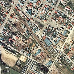
日本語: 広尾線(廃線)大樹駅 1977年。周囲約500m範囲。右下が広尾方面。 |
| Date | |
| Source | 国土交通省 国土画像情報(カラー空中写真)を基に作成 |
| Author | Nisanyongo |
| Permission (Reusing this file) |
下記を参照して下さい |
Licensing

|
The copyright holder of this file, the Ministry of Land, Infrastructure, Transport and Tourism of Japan, allows anyone to use it for any purpose, provided that the copyright holder is properly attributed. Redistribution, derivative work, commercial use, and all other use is permitted. |
Attribution:
Copyright © National Land Image Information (Color Aerial Photographs), Ministry of Land, Infrastructure, Transport and Tourism
|
 |
This image is copyrighted by the Ministry of Land, Infrastructure, Transport and Tourism of Japan. For terms of use, see the stipulation to use of National Land Information (in Japanese) and message from MLIT (in Japanese and English). When you display this image on an article, include the following phrase in the description: "Made based on National Land Image Information (Color Aerial Photographs), Ministry of Land, Infrastructure, Transport and Tourism".
|
File history
Click on a date/time to view the file as it appeared at that time.
| Date/Time | Thumbnail | Dimensions | User | Comment | |
|---|---|---|---|---|---|
| current | 14:51, 20 March 2010 | | 868 × 868 (700 KB) | Nisanyongo | {{Information |Description=広尾線(廃線)大樹駅 1977年。周囲約500m範囲。右下が広尾方面。 |Source={{国土航空写真}} |Date=2010/3/20 |Author=Nisanyongo |Permission=下記を参照して下さい |other_versions= }} {{国土� |
File usage
The following pages on the English Wikipedia use this file (pages on other projects are not listed):
Global file usage
The following other wikis use this file: