
File:The Four Crosses - geograph.org.uk - 1310947.jpg
No higher resolution available.
The_Four_Crosses_-_geograph.org.uk_-_1310947.jpg (640 × 410 pixels, file size: 67 KB, MIME type: image/jpeg)
| This is a file from the Wikimedia Commons. Information from its description page there is shown below. Commons is a freely licensed media file repository. You can help. |
Summary
| Description |
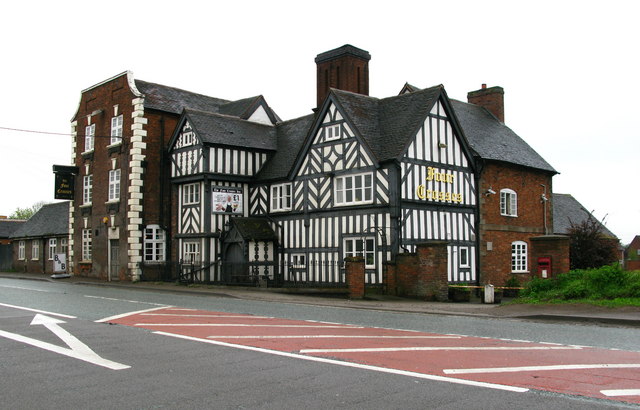
English: The Four Crosses, near to Four Crosses, Staffordshire, Great Britain.
The heyday of the Four Crosses Inn seems to have been in the 18th century. Its location on the Watling Street made it an important stopping off point on the journey from London to Ireland. People travelling from London tended to sleep at Birmingham, dine at the Four Crosses and then sleep again at Newport, before going on to Chester the following day. |
| Date | |
| Source | From geograph.org.uk; transferred by User:MrPanyGoff using geograph_org2commons. |
| Author | David Rogers |
| Permission (Reusing this file) |
Creative Commons Attribution Share-alike license 2.0 |
| Attribution (required by the license) | David Rogers / The Four Crosses / |
| Camera location | | View this and other nearby images on: OpenStreetMap |
|---|
| Object location | | View this and other nearby images on: OpenStreetMap |
|---|
_region:GB-EAW_heading:135.00&language=en)
Licensing

|
This image was taken from the Geograph project collection. See this photograph's page on the Geograph website for the photographer's contact details. The copyright on this image is owned by David Rogers and is licensed for reuse under the Creative Commons Attribution-ShareAlike 2.0 license.
|
This file is licensed under the Creative Commons Attribution-Share Alike 2.0 Generic license.
Attribution: David Rogers
- You are free:
- to share – to copy, distribute and transmit the work
- to remix – to adapt the work
- Under the following conditions:
- attribution – You must give appropriate credit, provide a link to the license, and indicate if changes were made. You may do so in any reasonable manner, but not in any way that suggests the licensor endorses you or your use.
- share alike – If you remix, transform, or build upon the material, you must distribute your contributions under the same or compatible license as the original.
File history
Click on a date/time to view the file as it appeared at that time.
| Date/Time | Thumbnail | Dimensions | User | Comment | |
|---|---|---|---|---|---|
| current | 10:43, 12 November 2010 | | 640 × 410 (67 KB) | File Upload Bot (Magnus Manske) |
File usage
The following pages on the English Wikipedia use this file (pages on other projects are not listed):