
File:The Manners Stone - geograph.org.uk - 1048201.jpg
The_Manners_Stone_-_geograph.org.uk_-_1048201.jpg (640 × 480 pixels, file size: 229 KB, MIME type: image/jpeg)
| This is a file from the Wikimedia Commons. Information from its description page there is shown below. Commons is a freely licensed media file repository. You can help. |
Summary
| Description |
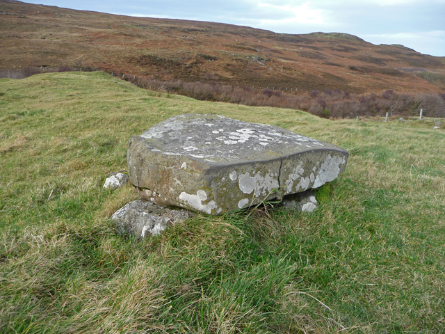
English: The Manners Stone The Manners Stone is marked as such on the OS map. It sits in a field near the end of the surfaced road at Galtrigill. Once there was a big village here. Now there is just a scattering of ruins.
It is only about half a metre square, and is not particularly distinctive. It is probably mostly unnoticed even by the very few people who venture this way. It is supported by three smaller stones and has some inscriptions on it, which appear most likely to be mid 20th century graffiti. The stone is reputed to give good manners to those who stand on it. Children of the village who transgressed would be sent to stand on it until they found their manners'. There are other versions of the story. Some say that anyone who sits bare arsed on the stone will have fertility and good fortune. Others say that the villagers of Galtrigill came here each year to bow to this stone of the ancient gods, in a belief that this would bring a good harvest. It seems likely to me that the last of these theories is the right one. The gaelic word manadh (pronounced mana) means omen. Manners is probably an anglicisation of Manadh. |
| Date | |
| Source | From geograph.org.uk |
| Author | John Allan |
| Attribution (required by the license) | John Allan / The Manners Stone / |
| Camera location | | View this and other nearby images on: OpenStreetMap |
|---|
_heading:0.00&language=en)
| Object location | | View this and other nearby images on: OpenStreetMap |
|---|
_heading:0.00&language=en)
Licensing

|
This image was taken from the Geograph project collection. See this photograph's page on the Geograph website for the photographer's contact details. The copyright on this image is owned by John Allan and is licensed for reuse under the Creative Commons Attribution-ShareAlike 2.0 license.
|
- You are free:
- to share – to copy, distribute and transmit the work
- to remix – to adapt the work
- Under the following conditions:
- attribution – You must give appropriate credit, provide a link to the license, and indicate if changes were made. You may do so in any reasonable manner, but not in any way that suggests the licensor endorses you or your use.
- share alike – If you remix, transform, or build upon the material, you must distribute your contributions under the same or compatible license as the original.

|
The categories of this image need checking. You can do so here.
|
File history
Click on a date/time to view the file as it appeared at that time.
| Date/Time | Thumbnail | Dimensions | User | Comment | |
|---|---|---|---|---|---|
| current | 22:40, 23 February 2011 | | 640 × 480 (229 KB) | GeographBot | == {{int:filedesc}} == {{Information |description={{en|1=The Manners Stone The Manners Stone is marked as such on the OS map. It sits in a field near the end of the surfaced road at Galtrigill. Once there was a big village here. Now there is just a scatte |
File usage
Global file usage
The following other wikis use this file:
- Usage on www.wikidata.org