
File:The Situation in Hasakah.svg

Size of this PNG preview of this SVG file: 600 × 313 pixels. Other resolutions: 320 × 167 pixels | 640 × 334 pixels | 1,024 × 534 pixels | 1,280 × 668 pixels | 2,560 × 1,335 pixels.
Original file (SVG file, nominally 600 × 313 pixels, file size: 524 KB)
| This is a file from the Wikimedia Commons. Information from its description page there is shown below. Commons is a freely licensed media file repository. You can help. |
Summary
| Description |
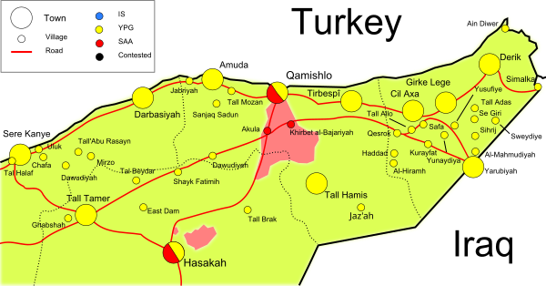
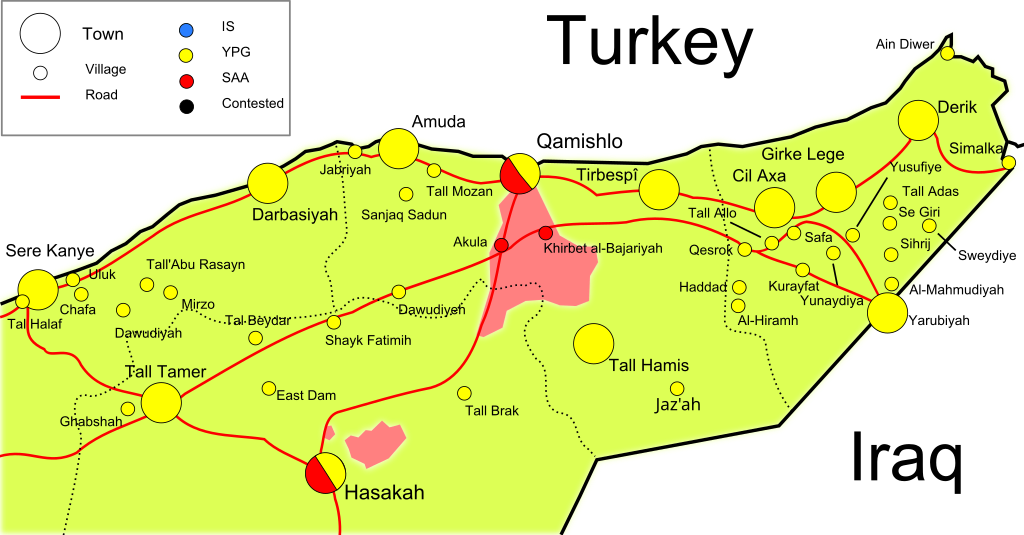
English: A territory map regarding the current conflict in Hasakah Province.. |
| Date | |
| Source | based on Cities and towns during the Syrian civil war |
| Author | Mouradi |
Licensing
I, the copyright holder of this work, hereby publish it under the following license:
This file is licensed under the Creative Commons Attribution-Share Alike 3.0 Unported license.
- You are free:
- to share – to copy, distribute and transmit the work
- to remix – to adapt the work
- Under the following conditions:
- attribution – You must give appropriate credit, provide a link to the license, and indicate if changes were made. You may do so in any reasonable manner, but not in any way that suggests the licensor endorses you or your use.
- share alike – If you remix, transform, or build upon the material, you must distribute your contributions under the same or compatible license as the original.
File history
Click on a date/time to view the file as it appeared at that time.
| Date/Time | Thumbnail | Dimensions | User | Comment | |
|---|---|---|---|---|---|
| current | 14:40, 23 March 2016 | | 600 × 313 (524 KB) | Joan301009 | update |
| 15:11, 6 August 2015 |  | 600 × 313 (526 KB) | Joan301009 | Fixing some errors | |
| 22:55, 28 February 2015 |  | 600 × 313 (530 KB) | EllsworthSK | cor | |
| 22:46, 28 February 2015 |  | 600 × 313 (530 KB) | EllsworthSK | Tal Brak, Tal Hamis fallen, Tal Helef was in YPG hands for over a year. | |
| 22:46, 26 February 2015 |  | 600 × 313 (530 KB) | Mouradi | Added Jaz'ah | |
| 22:22, 17 January 2014 |  | 600 × 313 (528 KB) | Hanibal911 | YPG not lost Tall Brak | |
| 22:19, 17 January 2014 |  | 600 × 313 (528 KB) | Hanibal911 | no confirmation that YPG lost control of Tall Brak | |
| 00:03, 8 January 2014 |  | 600 × 313 (528 KB) | Semsûrî | YPG lost Tal Brak | |
| 13:47, 29 December 2013 |  | 600 × 313 (528 KB) | Semsûrî | Updated the map with http://pydrojava.net/eng/index.php/news/151-the-town-of-tell-brak-is-completely-liberated-by-ypg-units Tell Brak is under YPG-control | |
| 09:50, 7 November 2013 |  | 600 × 313 (527 KB) | EllsworthSK | Removed ISIS presence from the west part of the map per source in the article, changed Hasakah to YPG-regime controlled per Template:Syrian_civil_war_detailed_map |
File usage
The following pages on the English Wikipedia use this file (pages on other projects are not listed):
Global file usage
The following other wikis use this file:
- Usage on es.wikipedia.org
- Usage on fa.wikipedia.org
- Usage on ku.wikipedia.org
- Usage on pl.wikipedia.org
- Usage on sr.wikinews.org
- Usage on zh.wikipedia.org