
File:The whole map of Sanmon-Santō Sakamoto Sōezu (2nd volume).png

Original file (11,863 × 8,391 pixels, file size: 166.94 MB, MIME type: image/png)
| This is a file from the Wikimedia Commons. Information from its description page there is shown below. Commons is a freely licensed media file repository. You can help. |
Summary
| Warning | The original file is very high-resolution. It might not load properly or could cause your browser to freeze when opened at full size. |
|---|
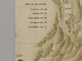
| English: Sanmon-Santō Sakamoto Sōezu (2nd volume)
日本語: 『山門三塔坂本惣絵図』 (第2鋪) |
|
|---|---|
| Artist |
English: Author unknown
日本語: 作者不詳 |
| Title |
English: Sanmon-Santō Sakamoto Sōezu (2nd volume)
日本語: 『山門三塔坂本惣絵図』 (第2鋪) |
| Description |
English:
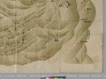
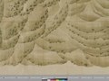
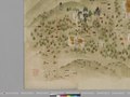
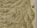
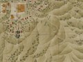
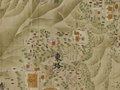
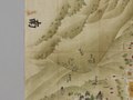
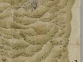
This old map is the 2nd of two volumes in the series. The title of these maps are Sanmon-Santō Sakamoto Sōezu. The 1st volume of the maps shows Yokawa area in the precincts of Enryakuji Temple on Mount Hiei and Sakamoto area at the foot of Mount Hiei, Otsu City, Shiga Prefecture, Japan. The 2nd volume of the maps shows Tō-dō area and Sai-tō area in the precincts of Enryakuji Temple on Mount Hiei, Otsu City, Shiga Prefecture, Japan.日本語:
この古地図は、2つ(2鋪(ほ))の地図のうちのひとつ(第2鋪)です。 これらの地図の題名は、『山門三塔坂本惣絵図』(さんもんさんとう さかもと そうえず)です。 第1鋪の地図には、滋賀県大津市内の、比叡山延暦寺の境内にある横川地区と、比叡山の東側のふもとにある坂本地区が描かれています。 .png) English: Sanmon-Santō Sakamoto Sōezu 1st volume (Yokawa area in Enryakuji Temple on Mount Hiei and Sakamoto area) .png) English: Sanmon-Santō Sakamoto Sōezu 2nd volume (Tō-dō area and Sai-tō area in Enryakuji Temple on Mount Hiei) |
| Date |
日本語: 1767年(江戸時代中期)作成 (*1) (*2) (*3) |
| Dimensions |
English:
日本語:
|
| Collection |
English: The National Archives of Japan (NAJ)
日本語: 国立公文書館 |
| Accession number | |
| Place of creation |
English: Japan
日本語: 日本 |
| Object history |
English:
These maps were made in Japan in 1767 (the middle of the Edo period, Japan) (*1) (*2) (*3). Currently, these maps are one of the collections in the National Archives of Japan (NAJ). (These maps were formerly one of the collections in the Japanese Cabinet Library.) |
| Credit line |
English:
I, Yukinobu Kurata, followed the regular procedure of the National Archives of Japan (NAJ), requested the use of the digital data (image files) of the two maps, paid the following fees and other charges, and obtained the image files from NAJ, April 2021.
Each of the two maps (1st and 2nd volume) is too big to take the picture of it at one time. (The sizes of 1st and 2nd volume : Width 280cm x Height 187.5cm, Width 279cm x Height 187.5cm.) Therefore, NAJ took the pictures for each parts of them separately. Each of the two maps was divided into 16 pieces of image files. (In addition to those, NAJ took the pictures of the front cover and the back cover for each maps. Eventually the number of the image files of the two maps is 18 for each (total is 36).) I connected these 16 pieces of image files and made this image file of the whole map of Sanmon-Santō Sakamoto Sōezu (2nd volume). I publish this image file in the public domain in accordance with the terms of secondary use of digital images, etc of NAJ.
日本語:
私(倉田幸暢)は、正規の手続きに従って、国立公文書館に対して、これらの2つの地図のデジタルデータ(画像ファイル)の利用申請を提出し、下記の手数料等を支払って、2021年4月にこれらの2つの地図の画像ファイルを入手しました。
第1鋪と第2鋪の2枚の地図は、それぞれ、縦横サイズが大きいために、国立公文書館は、1回の撮影で地図全体を1枚の写真におさめることができませんでした。 (※第1鋪と第2鋪の縦横サイズは、それぞれ、幅280cm×高さ187.5cm、幅279cm×高さ187.5cm です。) そのため、国立公文書館は、それぞれの地図ごとに、1枚の地図を複数回に分けて撮影しました。 それによって、2枚の地図は、それぞれ、16枚の画像ファイルに分割されました。 (また、それに加えて、それぞれの地図の、表表紙と裏表紙の写真も撮影されました。最終的に、2枚の地図の画像ファイルは、それぞれ18枚になりました(合計36枚)。) 私は、16枚に分割された画像ファイルをつなぎ合わせて、この『山門三塔坂本惣絵図』の第2鋪の地図の全体図の画像ファイルをつくりました。 私は、国立公文書館の「デジタル画像等の二次利用についての利用規約」にもとづき、この画像ファイルを、パブリックドメインとして公開します。 |
| References |
English:
日本語:
|
| Source/Photographer |
English:
|
| Other versions |
Image files Sanmon-Santō Sakamoto Sōezu 2nd volume English: Sanmon-Santō Sakamoto Sōezu 2nd volume (Tō-dō area and Sai-tō area in Enryakuji Temple on Mount Hiei) JPEG (.jpg) TIFF (.tif) |
.jpg)
.jpg)
.jpg)
.jpg)
.jpg)
.jpg)
.jpg)
.jpg)
.jpg)
.jpg)
.jpg)
.jpg)
.jpg)
.jpg)
.jpg)
.jpg)
.jpg)
.jpg)


Licensing
|
This is a faithful photographic reproduction of a two-dimensional, public domain work of art. The work of art itself is in the public domain in its source country for the following reason:
It is also in the public domain in the United States for the following reason:
The official position taken by the Wikimedia Foundation is that "faithful reproductions of two-dimensional public domain works of art are public domain".
This photographic reproduction is therefore also considered to be in the public domain in the United States. In other jurisdictions, re-use of this content may be restricted; see Reuse of PD-Art photographs for details.
| |||||||

.png)
File history
Click on a date/time to view the file as it appeared at that time.
| Date/Time | Thumbnail | Dimensions | User | Comment | |
|---|---|---|---|---|---|
| current | 12:45, 20 June 2021 | | 11,863 × 8,391 (166.94 MB) | Yukinobu Kurata | Uploaded a work by 不明 from https://www.digital.archives.go.jp/file/1227276.html with UploadWizard |
File usage
Global file usage
The following other wikis use this file:
- Usage on ja.wikipedia.org
- Usage on www.wikidata.org
.png)