
File:Village sign, Widecombe-in-the-Moor - geograph.org.uk - 1237758.jpg
No higher resolution available.
Village_sign,_Widecombe-in-the-Moor_-_geograph.org.uk_-_1237758.jpg (640 × 560 pixels, file size: 121 KB, MIME type: image/jpeg)
| This is a file from the Wikimedia Commons. Information from its description page there is shown below. Commons is a freely licensed media file repository. You can help. |
Summary
| Description |
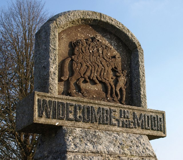
English: Village sign, Widecombe-in-the-Moor The obligatory image of Widecombe for the tripper, on the green by the church. Tim Sandles provides an excellent analysis of the famous song at http://www.legendarydartmoor.co.uk/widde2-fair.htm , from which the following is taken: "the noted folklorist Theo Brown ... contended that the concept of a spectral grey/white horse came from mainland Europe. It is suggested that the motif of the song was brought over to Dartmoor by German tinners who came across to work in the mines during the Elizabethan period. Some of these miners came from the Harz mountain region where there (along with many other European regions) was a tradition of der Schimmelreiter or the rider on a grey/white horse, the idea being that the grey horse was a guide to the Otherworld which would lead the souls of the departed into the venerated realms of the dead. Therefore in the contexts of Tom Pearce's grey mare, the reason he "sat down on a stone, and he cried" was because he realised that the grey horse's death meant all future spirits were condemned to oblivion as they would have no spirit guide to take them to the Otherworld. The whole concept of the belief was that the grey mare represented an entity which hovered between life and death and acted as a "boundary figure" without which no human soul can be led into the life-after." |
| Date | |
| Source | From geograph.org.uk |
| Author | Derek Harper |
| Attribution (required by the license) | Derek Harper / Village sign, Widecombe-in-the-Moor / |
| Camera location | | View this and other nearby images on: OpenStreetMap |
|---|
_heading:180.00&language=en)
| Object location | | View this and other nearby images on: OpenStreetMap |
|---|
_heading:180.00&language=en)
Licensing

|
This image was taken from the Geograph project collection. See this photograph's page on the Geograph website for the photographer's contact details. The copyright on this image is owned by Derek Harper and is licensed for reuse under the Creative Commons Attribution-ShareAlike 2.0 license.
|
This file is licensed under the Creative Commons Attribution-Share Alike 2.0 Generic license.
Attribution: Derek Harper
- You are free:
- to share – to copy, distribute and transmit the work
- to remix – to adapt the work
- Under the following conditions:
- attribution – You must give appropriate credit, provide a link to the license, and indicate if changes were made. You may do so in any reasonable manner, but not in any way that suggests the licensor endorses you or your use.
- share alike – If you remix, transform, or build upon the material, you must distribute your contributions under the same or compatible license as the original.
File history
Click on a date/time to view the file as it appeared at that time.
| Date/Time | Thumbnail | Dimensions | User | Comment | |
|---|---|---|---|---|---|
| current | 14:51, 26 February 2011 | | 640 × 560 (121 KB) | GeographBot | == {{int:filedesc}} == {{Information |description={{en|1=Village sign, Widecombe-in-the-Moor The obligatory image of Widecombe for the tripper, on the green by the church. Tim Sandles provides an excellent analysis of the famous song at http://www.legenda |
File usage
The following pages on the English Wikipedia use this file (pages on other projects are not listed):