
File:Wien - U-Bahn-Station Friedensbrücke.JPG

Size of this preview: 800 × 419 pixels. Other resolutions: 320 × 167 pixels | 640 × 335 pixels | 1,024 × 536 pixels | 1,280 × 670 pixels | 2,560 × 1,340 pixels | 5,100 × 2,669 pixels.
Original file (5,100 × 2,669 pixels, file size: 9.82 MB, MIME type: image/jpeg)
| This is a file from the Wikimedia Commons. Information from its description page there is shown below. Commons is a freely licensed media file repository. You can help. |
Summary
| Description |
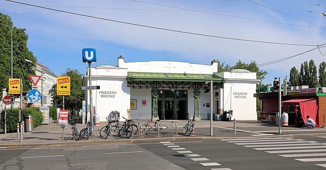
Deutsch: Die U-Bahn-Station Friedensbrücke im 9. Wiener Gemeindebezirk Alsergrund. Ursprünglich nach Plänen von Otto Wagner gebaut und 1901 als Station Brigittabrücke der Donaukanallinie der Wiener Dampfstadtbahn eröffnet. Nachdem man ab 1924 an Stelle der Brigittabrücke eine neue Brücke baute und diese Friedensbrücke nannte (in Erinnerung an den Friedensvertrag von St. Germain), erfolgte im Jahr 1926 die Umbenennung der Station in Friedensbrücke. Im Zuge des Wiener U-Bahnbaues ab 1969 wurde die Station umgebaut. Anschließend fand ab 8. Mai 1976 als erster Wiener U-Bahnabschnitt der „erweiterte Probebetrieb mit Fahrgästen“ zwischen den beiden Stationen Heiligenstadt und Friedensbrücke statt. |
| Date | |
| Source | Own work |
| Author | C.Stadler/Bwag |
| Permission (Reusing this file) |
Deutsch: Hallo, du darfst mein Foto kostenlos nutzen, aber nenne mich bitte als Fotograf, beispielsweise „Foto: C.Stadler/Bwag“ oder © C.Stadler/Bwag; CC-BY-SA-4.0. Auf mehr Angaben bestehe ich nicht - im Gegensatz zu manch anderen, die die Vorgaben der unten angeführten Lizenzierung auf Punkt und Beistrich einfordern. English: Feel free to use my photos, but please mention me as the author like © C.Stadler/Bwag or © C.Stadler/Bwag; CC-BY-SA-4.0 (that's good enough) and if you want send me a message: bwag@gmx.net. |
| Object location | | View this and other nearby images on: OpenStreetMap |
|---|
| Camera location | | View this and other nearby images on: OpenStreetMap |
|---|
Licensing
I, the copyright holder of this work, hereby publish it under the following license:
This file is licensed under the Creative Commons Attribution-Share Alike 4.0 International license.
- You are free:
- to share – to copy, distribute and transmit the work
- to remix – to adapt the work
- Under the following conditions:
- attribution – You must give appropriate credit, provide a link to the license, and indicate if changes were made. You may do so in any reasonable manner, but not in any way that suggests the licensor endorses you or your use.
- share alike – If you remix, transform, or build upon the material, you must distribute your contributions under the same or compatible license as the original.
File history
Click on a date/time to view the file as it appeared at that time.
| Date/Time | Thumbnail | Dimensions | User | Comment | |
|---|---|---|---|---|---|
| current | 15:46, 8 December 2020 | | 5,100 × 2,669 (9.82 MB) | Bwag | {{Information |Description= {{de|1=Die U-Bahn-Station Friedensbrücke im 9. Wiener Gemeindebezirk Alsergrund.<br/>Ursprünglich nach Plänen von Otto Wagner gebaut und 1901 als Station ''Brigittabrücke'' der Donaukanallinie der Wiener Dampfstadtbahn eröffnet. Nachdem man ab 1924 an Stelle der Brigittabrücke eine neue Brücke baute und diese Friedensbrücke nannte (in Erinnerung an den Friedensvertrag von St. Germain), erfolgte im Jahr 1926 die Umbenennung der Station in ''Friedensbrücke''. Im Zug... |
File usage
The following pages on the English Wikipedia use this file (pages on other projects are not listed):
Global file usage
The following other wikis use this file:
- Usage on de.wikipedia.org
- Usage on fr.wikipedia.org
- Usage on hu.wikipedia.org
- Usage on id.wikipedia.org
- Usage on it.wikipedia.org
- Usage on lmo.wikipedia.org
- Usage on nl.wikipedia.org
- Usage on pl.wikipedia.org
- Usage on www.wikidata.org