
File:Woods alongside the Stuckiedow Burn - geograph.org.uk - 1301331.jpg
Woods_alongside_the_Stuckiedow_Burn_-_geograph.org.uk_-_1301331.jpg (640 × 480 pixels, file size: 67 KB, MIME type: image/jpeg)
| This is a file from the Wikimedia Commons. Information from its description page there is shown below. Commons is a freely licensed media file repository. You can help. |
Summary
| Description |
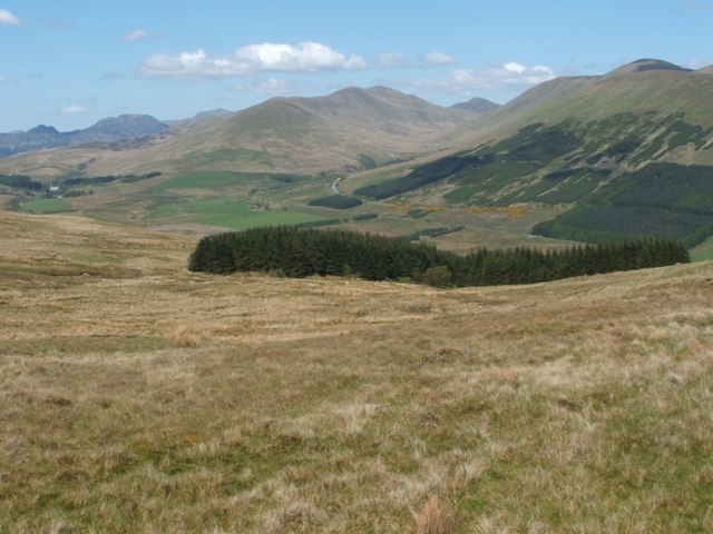
English: Woods alongside the Stuckiedow Burn. The woods in the middle distance form a narrow strip on either side of the Stuckiedow Burn. In those woods, the burn descends towards the floor of Glen Fruin, which is the area of low ground that runs from left to right across this photo. For the valley of the Stuckiedow Burn, see: 1301332
The far side of the glen is traversed by two roads. The closer road is also the older; the various farms in the floor of the glen lie alongside it. The newer Glen Fruin Road follows an almost parallel course, just behind it; part of that road is highlighted here by yellow gorse bushes. Visible right of centre in the background is another glen, that of the upper reaches of the Luss Water; back towards the head of that glen, a single peak, Cruach an t-Sìdhein (NS2796), can be seen through a gap. At the right-hand edge of the picture, Auchengaich Hill (NS2890) almost hides the taller Beinn Tharsuinn (NS2991). On the other side of that glen, the hills just left of centre range from the Strone (NS2692) at the near end to the more distant Beinn a' Mhanaich (NS2694). Finally, the more distant rocky peaks near the left-hand edge of the image are the Saddle (NS2296), on the left, with the larger Beinn Reithe (NS2298) to its right; just to the right again, a small part of Cnoc Coinnich (NN2300) is visible behind the nearer hills. |
| Date | |
| Source | From geograph.org.uk |
| Author | Lairich Rig |
| Attribution (required by the license) | Lairich Rig / Woods alongside the Stuckiedow Burn / |
| Camera location | | View this and other nearby images on: OpenStreetMap |
|---|
_heading:0.00&language=en)
| Object location | | View this and other nearby images on: OpenStreetMap |
|---|
_heading:0.00&language=en)
Licensing

|
This image was taken from the Geograph project collection. See this photograph's page on the Geograph website for the photographer's contact details. The copyright on this image is owned by Lairich Rig and is licensed for reuse under the Creative Commons Attribution-ShareAlike 2.0 license.
|
- You are free:
- to share – to copy, distribute and transmit the work
- to remix – to adapt the work
- Under the following conditions:
- attribution – You must give appropriate credit, provide a link to the license, and indicate if changes were made. You may do so in any reasonable manner, but not in any way that suggests the licensor endorses you or your use.
- share alike – If you remix, transform, or build upon the material, you must distribute your contributions under the same or compatible license as the original.
File history
Click on a date/time to view the file as it appeared at that time.
| Date/Time | Thumbnail | Dimensions | User | Comment | |
|---|---|---|---|---|---|
| current | 15:09, 27 February 2011 | | 640 × 480 (67 KB) | GeographBot | == {{int:filedesc}} == {{Information |description={{en|1=Woods alongside the Stuckiedow Burn The woods in the middle distance form a narrow strip on either side of the Stuckiedow Burn. In those woods, the burn descends towards the floor of Glen Fruin, whi |
File usage
Global file usage
The following other wikis use this file:
- Usage on ceb.wikipedia.org
- Usage on www.wikidata.org