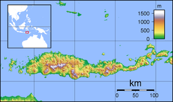
Maumere
Maumere | |
|---|---|
Town | |
 | |
| Coordinates: 8°37′20″S 122°12′44″E / 8.62222°S 122.21222°E | |
| Country | Indonesia |
| Region | Lesser Sunda Islands |
| Province | East Nusa Tenggara |
| Regency | Sikka |
| Area | |
| • Total | 149.41 km2 (57.69 sq mi) |
| Population (mid 2023 estimate) | |
| • Total | 91,550 |
| • Density | 610/km2 (1,600/sq mi) |
| [1] | |
| Time zone | UTC+8 (WITA) |
Maumere is the administrative seat of the Sikka Regency and the second largest town (its nominal population has recently overtaken Ende, but of these over 10,500 live in rural areas on outlying islands) on Flores Island, Indonesia. It lies on the north coast of the island and the port is in the north-west part of the town. Administratively the town is not a single district (kecamatan) within the regency, but is divided into three districts – Alok Barat (West Alok), Alok and Alok Timur (East Alok) – although the latter two districts also include a number of substantial islands off the north coast of Flores.
Population[edit]
In 1992 Maumere had a total population of about 70,000,[2] but the town suffered considerable damage in the 1992 Flores earthquake and tsunami, with 90 percent of all buildings being destroyed.[2] The Census population in 2010 was 82,039[3] and 87,720 in 2020;[4] the official estimate as at mid 2023 was 91,550.[1]
In 2005, the Roman Catholic Diocese of Maumere was established in the town.
The reefs in areas surrounding Maumere (the Maumere Gulf) were once considered some of the finest diving in the world. However, a 2007 report found that 75% of the coral reefs had been significantly damaged or destroyed by the practice of bomb fishing, the use of toxic chemicals in fishing, and due to earthquakes.[5] One priority of the local community and government is the promotion of tourism. An annual cultural event, Maumere in Love, has been initiated as a step towards fostering both local and wider interest in the region around Maumere.[6]
Villages[edit]
The 3 districts (kecamatan) which comprise Maumere are sub-divided into 13 urban (kelurahan) and 8 rural (desa) villages:[7][circular reference]
- Alok Barat (West Alok) consists of the 4 kelurahan of Hewuli, Wailiti, Wolomarang and Wuring, with 22,993 inhabitants in mid 2021;[8]
- Alok consists of the 4 kelurahan of Kabor, Kota Uneng, Madawat and Nangalimang, with 26,724 inhabitants in mid 2021;[8]
plus the 3 desa of Gunung Sari, Pemana (together comprising Pemana Island offshore, with 4,268 inhabitants in 2021) and Samparong (comprising Samparong Island, further north in the Flores Sea, with 1,532 inhabitants in 2021); - Alok Timur (East Alok) consists of the 5 kelurahan of Beru, Kota Baru, Nangameting, Waioti and Wairotang, with 23,367 inhabitants in mid 2021;[8]
plus the 5 desa of Lepolima (2,088) and Watugong (2,728), both also on Flores Island but immediately south of the 5 kelurahan,
while Kojadoi (1,471) and Kojagete (1,489) together comprise Koja Island (or Pulau Besar), and Perumaan consists of nearly Perumaan Island and similar small islands, all closer to the northwest coast of Talibura District.
Thus the population of the urban town itself in 2021 was 77,900, with the other 10,576 inhabitants being on the various offshore islands.
Mother of All Nations[edit]
Mother of All Nations (Indonesian: Bunda Segala Bangsa) is a statue of Mother Mary in Nilo hill, 5 kilometres or 3.1 miles south-west from Maumere. The statue stands 18 metres or 59 feet tall, but with its pedestal and foundation it is 28 metres or 92 feet tall. The 6-ton copper-clad statue was constructed on 2005, located at the peak of the 500 metres or 1,640 feet Keli hill, Nilo village, and has become the tallest statue raised in Sikka Regency.
Transportation[edit]
The city is served by Frans Xavier Seda Airport or Maumere Airport.
Climate[edit]
Maumere has a tropical savanna climate (Köppen Aw) with a long dry season and short wet season.
| Climate data for Maumere | |||||||||||||
|---|---|---|---|---|---|---|---|---|---|---|---|---|---|
| Month | Jan | Feb | Mar | Apr | May | Jun | Jul | Aug | Sep | Oct | Nov | Dec | Year |
| Mean daily maximum °C (°F) | 30.4 (86.7) |
30.1 (86.2) |
30.6 (87.1) |
31.4 (88.5) |
31.4 (88.5) |
31.0 (87.8) |
30.9 (87.6) |
31.1 (88.0) |
31.6 (88.9) |
32.1 (89.8) |
32.1 (89.8) |
31.1 (88.0) |
31.2 (88.1) |
| Daily mean °C (°F) | 26.5 (79.7) |
26.3 (79.3) |
26.4 (79.5) |
26.7 (80.1) |
26.5 (79.7) |
25.9 (78.6) |
25.4 (77.7) |
25.3 (77.5) |
25.9 (78.6) |
26.8 (80.2) |
27.5 (81.5) |
27.0 (80.6) |
26.4 (79.4) |
| Mean daily minimum °C (°F) | 22.7 (72.9) |
22.5 (72.5) |
22.3 (72.1) |
22.1 (71.8) |
21.7 (71.1) |
20.8 (69.4) |
19.9 (67.8) |
19.6 (67.3) |
20.3 (68.5) |
21.6 (70.9) |
23.0 (73.4) |
23.0 (73.4) |
21.6 (70.9) |
| Average rainfall mm (inches) | 188 (7.4) |
171 (6.7) |
146 (5.7) |
89 (3.5) |
46 (1.8) |
29 (1.1) |
19 (0.7) |
7 (0.3) |
8 (0.3) |
29 (1.1) |
84 (3.3) |
169 (6.7) |
985 (38.6) |
| Source: Climate-Data.org[9] | |||||||||||||
References[edit]
- ^ a b Badan Pusat Statistik, Jakarta, 28 February 2024, Kabupaten Sikka Dalam Angka 2024 (Katalog-BPS 1102001.5307)
- ^ a b Reports 1–9 United Nations Department of Humanitarian Affairs
- ^ Biro Pusat Statistik, Jakarta, 2011.
- ^ Badan Pusat Statistik, Jakarta, 2021.
- ^ "Some 75 percent of coral reefs in Maumere Gulf damaged", ANT - LKBN Antara (Indonesia), 31 May 2007
- ^ ID Nugroho, 'In love with Maumere', The Jakarta Post, 24 February 2012.
- ^ id:Kabupaten Sikka
- ^ a b c Badan Pusat Statistik, Jakarta, 2022.
- ^ "Climate: Maumere". Climate-Data.org. Retrieved 18 November 2020.


