
Nakhon Ratchasima province
This article is written like a travel guide. (January 2015) |
Nakhon Ratchasima
นครราชสีมา | |
|---|---|
| Nakhon Ratchasima province | |
  .jpg)  .jpg) (clockwise from upper-left): Phimai Castle, Thao Suranaree Monument, Thai house at Jim Thompson Farm, Chum Phon Gate, Buddha statue at Phanom Wan Castle | |
 Flag  Seal | |
| Nickname: Korat (Thai: โคราช) | |
| Motto(s): เมืองหญิงกล้า ผ้าไหมดี หมี่โคราช ปราสาทหิน ดินด่านเกวียน ("City of brave women. Excellent silk. Mee Korat. Stone castles. Dan Kwian clay.") | |
 Map of Thailand highlighting Nakhon Ratchasima province | |
| Country | Thailand |
| Capital | Nakhon Ratchasima City |
| Government | |
| • Governor | Siam Sirimongkol (since October 2022)[1] |
| Area | |
| • Total | 20,736 km2 (8,006 sq mi) |
| • Rank | Ranked 1st |
| Population (2022)[3] | |
| • Total | 2,630,058 |
| • Rank | Ranked 2nd |
| • Density | 127/km2 (330/sq mi) |
| • Rank | Ranked 35th |
| Human Achievement Index | |
| • HAI (2022) | 0.6471 "average" Ranked 30th |
| GDP | |
| • Total | baht 275 billion (US$9.5 billion) (2019) |
| Time zone | UTC+7 (ICT) |
| Postal code | 30xxx |
| Calling code | 044 |
| ISO 3166 code | TH-30 |
| Website | www |
Nakhon Ratchasima (Thai: นครราชสีมา, pronounced [ná(ʔ).kʰɔ̄ːn râːt.t͡ɕʰā.sǐː.māː], often called Khorat (Thai: โคราช, pronounced [kʰōː.râːt])) (alternate spelling Korat) is one of Thailand's seventy-six provinces (changwat) lies in lower northeastern Thailand also called Isan. It is the country's largest province by area, has a population of approximately 2.7 million, and generates about 250 billion baht in GDP, the highest in Isan.[6] Neighbouring provinces are (clockwise, from north) Chaiyaphum, Khon Kaen, Buriram, Sa Kaeo, Prachinburi, Nakhon Nayok, Saraburi, and Lopburi.
The capital of the province is the city of Nakhon Ratchasima in Mueang Nakhon Ratchasima district, also called Khorat.
Geography[edit]

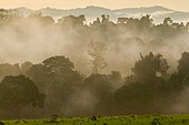
The province is at the west end of the Khorat Plateau, separated from the Chao Phraya river valley by the Phetchabun and Dong Phaya Yen mountain ranges. Two national parks are in the province: Khao Yai in the west and Thap Lan in the south. Both parks are in the forested mountains of the Sankamphaeng Range, the southern prolongation of the Dong Phaya Yen mountains. The total forest area is 3,193 km2 (1,233 sq mi) or 15.4 percent of provincial area.[2]
Nakhon Ratchasima is a large province on the northeastern plateau and acts as a gateway to other provinces in the northeast. It is 259 kilometres (161 mi) from Bangkok and has an area of around 20,494 square kilometres (7,913 sq mi). The province is rich in Khmer culture and has a long history.
National parks[edit]
There are two national parks, along with two other national parks, make up region 1 (Prachinburi) of Thailand's protected areas.
- Thap Lan National Park, 2,236 km2 (863 sq mi)[7]: 40
- Khao Yai National Park, 2,166 km2 (836 sq mi)[7]: 1
History[edit]
.jpg)
The area around Khorat was already an important centre in the times of the Khmer empire in the 11th century, as can be seen by the temple ruins in Phimai historical park. Nakhon Ratchasima province is one of the provinces where there is still a sizable northern Khmer population.[8]
A new walled city with a surrounding moat, designated as Nakhon Ratchasima, was built in the 17th century by order of the King Narai, as the easternmost "command post", guarding the kingdom's border. Nakhon Ratchasima continued this duty during the Bangkok Period, although it was briefly seized during Lao rebellion (1826–1828) in 1826, in the reign of King Rama III of Siam.
Nakhon Ratchasima has long been the most important political and economic centre in the northeastern region. In the late-19th century, the railroad reached Khorat and it became the junction of two main rail lines in the northeastern, Isan, region. In 1933, Nakhon Ratchasima was the stronghold of the royalist troops in the Boworadet Rebellion, as they fought against the new democratic government in Bangkok. In the 1950s, the Korat Royal Thai Air Force Base was built in Nakhon Ratchasima; from 1961 until 26 February 1976, this facility was also used as a base by the United States Air Force.
A mass shooting occurred in the province on 8 and 9 February 2020. The gunman killed 30 and wounded another 57 before being shot dead by police. It was the deadliest mass shooting in Thailand's history.
Nakhon Ratchasima was the birthplace of Thao Suranari who was born in 1771 and was the savior of Nakhon Ratchasima from King Chao Anouvong's army in 1826.
Symbols[edit]

The provincial seal depicts the revered heroine of Khorat, Thao Suranari (Thai: ท้าวสุรนารี).
A monument to Thao Suranari (real name: Khunying Mo; 1771–1852) stands in front of the old Pratu Chumphon gate. Also called "The Great Heroine of Khorat", Kunying Mo was the wife of the Siamese-appointed deputy governor of Nakhon Ratchasima during the reign of King Rama III. In 1826, Khunying Mo managed to repel the Laotian army led by Prince Anouvong of Vientiane who tried to reinstate control over the Khorat plateau. King Rama III conferred the title of Thao Suranari on Khunying Mo, as well as additional ones honouring her bravery.
The provincial tree and flower is the sathon (Millettia leucantha). The provincial aquatic animal is Hoven's carp (Leptobarbus hoevenii).
The provincial motto is "Land of brave women, fine silk material, Khorat rice noodles, Phimai Historical Park, and Dan Kwian ceramics".
The provincial color is orange
Administrative divisions[edit]
Provincial government[edit]

The province is divided into 32 districts (amphoes). The districts are further subdivided into 263 sub-districts (tambons) and 3,743 villages (mubans).[citation needed]
- Mueang Nakhon Ratchasima
- Khon Buri
- Soeng Sang
- Khong
- Ban Lueam
- Chakkarat
- Chok Chai
- Dan Khun Thot
- Non Thai
- Non Sung
- Kham Sakaesaeng
- Bua Yai
- Prathai
- Pak Thong Chai
- Phimai
- Huai Thalaeng
- Chum Phuang
- Sung Noen
- Kham Thale So
- Sikhio
- Pak Chong
- Nong Bun Mak
- Kaeng Sanam Nang
- Non Daeng
- Wang Nam Khiao
- Thepharak
- Mueang Yang
- Phra Thong Kham
- Lam Thamenchai
- Bua Lai
- Sida
- Chaloem Phra Kiat
NB: On 15 May 2007, the government upgraded all 81 "king amphoes" to "amphoes" to streamline administration.
| Class | Name | Area (km2) |
Distance to Provincial Hall (km) |
Established | Sub-districts (Units) |
Villages (Units) |
Population | ||
|---|---|---|---|---|---|---|---|---|---|
| Male | Female | Total | |||||||
| Special | Mueang Nakhon Ratchasima |
755.596 | 0 | 1895 | 25 | 243 | 212,627 | 221,211 | 433,838 |
| 1 | Dan Khun Thot |
1,428.14 | 84 | 1908 | 16 | 220 | 62,571 | 63,347 | 125,918 |
| 1 | Bua Yai |
305.028 | 101 | 1886 | 10 | 121 | 41,855 | 42,278 | 84,133 |
| 1 | Pak Thong Chai |
1,374.32 | 34 | 1910 | 16 | 213 | 56,716 | 58,950 | 115,666 |
| 1 | Phimai |
896.871 | 60 | 1900 | 12 | 208 | 64,421 | 66,024 | 130,445 |
| 1 | Sikhio |
1,247.07 | 45 | 1955 | 12 | 169 | 60,898 | 61,163 | 122,061 |
| 1 | Pak Chong |
1,825.17 | 85 | 1955 | 12 | 217 | 91,146 | 91,685 | 182,831 |
| 2 | Khon Buri |
1,816.85 | 58 | 1939 | 12 | 152 | 46,086 | 47,167 | 93,253 |
| 2 | Chakkarat |
501.672 | 40 | 1953 | 8 | 108 | 34,441 | 34,643 | 69,084 |
| 2 | Chok Chai |
503.917 | 30 | 1905 | 10 | 126 | 37,297 | 39,223 | 76,520 |
| 2 | Non Sung |
676.981 | 37 | 1897 | 16 | 195 | 62,639 | 65,374 | 128,013 |
| 2 | Prathai |
600.648 | 97 | 1961 | 13 | 148 | 38,622 | 38,761 | 77,282 |
| 2 | Sung Noen |
782.853 | 36 | 1901 | 11 | 125 | 38,429 | 40,181 | 78,610 |
| 2 | Huai Thalaeng |
495.175 | 65 | 1961 | 10 | 120 | 37,443 | 37,131 | 74,574 |
| 2 | Chum Phuang |
540.567 | 98 | 1959 | 9 | 130 | 40,918 | 41,038 | 82,161 |
| 3 | Soeng Sang |
1,200.24 | 88 | 1976 | 6 | 84 | 33,733 | 33,302 | 67,032 |
| 3 | Khong |
454.737 | 79 | 1938 | 10 | 155 | 40,052 | 41,076 | 81,128 |
| 3 | Non Thai |
541.994 | 28 | 1900 | 10 | 131 | 36,126 | 37,592 | 73,718 |
| 3 | Kham Sakaesaeng |
297.769 | 50 | 1968 | 7 | 72 | 21,423 | 21,753 | 43,176 |
| 3 | Kaeng Sanam Nang |
107.258 | 130 | 1986 | 5 | 56 | 18,782 | 19,054 | 37,836 |
| 3 | Wang Nam Khiao |
1,130.00 | 70 | 1992 | 5 | 83 | 20,416 | 20,503 | 40,910 |
| 4 | Ban Lueam |
218.875 | 85 | 1976 | 4 | 39 | 10,620 | 10,732 | 21,351 |
| 4 | Nong Bunmak |
590.448 | 52 | 1983 | 9 | 104 | 29,424 | 29,316 | 58,740 |
| 4 | Thepharak |
357.465 | 90 | 1995 | 4 | 58 | 12,002 | 11,451 | 23,453 |
| 4 | Phra Thong Kham |
359.522 | 45 | 1996 | 5 | 74 | 21,260 | 21,680 | 42,940 |
| 4 | Sida |
162.825 | 85 | 1997 | 5 | 50 | 12,087 | 12,133 | 24,220 |
| 4 | Bua Lai |
106.893 | 103 | 1997 | 4 | 45 | 12,374 | 12,450 | 24,824 |
| 4 | Non Daeng |
193.407 | 30 | 1989 | 5 | 65 | 12,597 | 12,984 | 25,581 |
| 4 | Kham Thale So |
203.605 | 22 | 1966 | 5 | 46 | 14,091 | 14,021 | 28,112 |
| 4 | Mueang Yang |
255.522 | 110 | 1995 | 4 | 44 | 14,321 | 14,038 | 28,359 |
| 4 | Lam Thamenchai |
308.457 | 120 | 1996 | 4 | 59 | 16,114 | 15,953 | 32,067 |
| 4 | Chaloem Phra Kiat |
254.093 | 18 | 1996 | 5 | 61 | 16,966 | 17,411 | 34,377 |
Local government[edit]

As of 26 November 2019 there are:[9] one Nakhon Ratchasima Provincial Administration Organisation (ongkan borihan suan changwat) and 90 municipal (thesaban) areas in the province. Nakhon Ratchasima municipality has city (thesaban nakhon) status. Bua Yai, Mueang Pak, Pak Chong and Sikhio municipalities have town (thesaban mueang) status. Further 85 subdistrict municipalities (thesaban tambon).The non-municipal areas are administered by 243 Subdistrict Administrative Organisations - SAO (ongkan borihan suan tambon).[3]
Economy[edit]


Khorat's economy has traditionally been heavily dependent on agriculture. It is known as a processing centre for Isan's production of rice, tapioca, and sugar. The Isan region accounts for half of Thailand's exports of those commodities. Khorat is also one of two sites in Thailand manufacturing disk drives by Seagate Technology, employing 12,100 workers in Khorat.[6][10]
Transport[edit]
- Air
Nakhon Ratchasima has Nakhon Ratchasima Airport, but it has no scheduled flights. The nearest working airport is in Buriram and has flights to and from Bangkok.
- Rail
The railway system in Nakhon Ratchasima is on both northeastern routes from Bangkok Railway Station. Nakhon Ratchasima province has eight main railway stations. In 2017, a 60-kilometre dual-track line will connect Korat to Khon Kaen province. It is the first segment of a dual track network that will connect Isan with the Laem Chabang seaport. Mueang District is served by two stations: Nakhon Ratchasima railway station and Thanon Chira Junction railway station.[6]
- Road
Highway 2 (Mittraphap Road) is the main route that connects nine districts in Nakhon Ratchasima including Muang district. This route also connects Nakhon Ratchasima to Saraburi and Khon Kaen provinces. Hwy 24 links Si Khio District from Hwy 2 to Pak Thongcha, Chok Chai, and Nong Bunnak Districts and to Buriram province. A new motorway connecting Khorat to Bangkok is under construction in 2016 and will reduce travel time on the 250 kilometre journey to just over two hours.[6]
Health[edit]
Nakhon Ratchasima has hospitals in mostly the public sector, but some in the private sector. Its main hospital is Maharat Nakhon Ratchasima Hospital, which is the largest provincial hospital operated by the Ministry of Public Health and one of the main hospitals for the MOPH-Mahidol CPIRD Program.[11] The province also has a university hospital, which is Suranaree University of Technology Hospital of the Institute of Medicine, Suranaree University of Technology.
Sports[edit]
- Football

Nakhon Ratchasima F.C. play in Thai League 1 top tier of Thailand football league. Despite the city of Korat having a population in excess of 400,000 and Nakhon Ratchasima province having a population in excess of 2.5 million, Nakhon Ratchasima F.C. struggled to attract more than 400 for most home games throughout their history, the club play in the 80th Birthday Stadium.
- Volleyball
Nakhon Ratchasima is the home of the four-times Men's Volleyball Thailand League winner, Nakhon Ratchasima the Mall and the three-times Women's Volleyball Thailand League winner, Nakhon Ratchasima the Mall.
Education[edit]

- Universities
There are four universities in the area.
- Nakhon Ratchasima Rajabhat University
- Rajamangala University of Technology Isan
- Suranaree University of Technology
- Vongchavalitkul University
- Schools
- Ratchasima Wittayalai School
- Saint Mary's College Nakhon Ratchasima
- Suranaree Wittaya School
- MBAC
- Boonwatthana
- Phimai Witthaya
- Assumption School Nakhon Ratchasima
- Fort Surathamphithak School
- Phoowittaya School (lab school project)
- Plookpanya School
- Koratpittayakom school
- Wangrongnoi school
- Phatongkhamwittaya school
- Surawiwat school in Suranaree University of Technology
- International schools
- St Stephen's International School (SIS) (Khao Yai Campus)
- Adventists International Mission School (AIMS) (Nakhon Ratchasima Campus)
- Anglo Singapore International School (Korat Campus)
- Wesley International School[12]
Human achievement index 2022[edit]
| Health | Education | Employment | Income |
| 33 | 58 | 10 | 55 |
| Housing | Family | Transport | Participation |

|
 |
.png)
| |
| 29 | 26 | 58 | 30 |
| Province Krabi, with an HAI 2022 value of 0.6471 is "average", occupies place 30 in the ranking. | |||
Since 2003, United Nations Development Programme (UNDP) in Thailand has tracked progress on human development at sub-national level using the Human achievement index (HAI), a composite index covering all the eight key areas of human development. National Economic and Social Development Board (NESDB) has taken over this task since 2017.[4]
| Rank | Classification |
| 1–13 | "High" |
| 14–29 | "Somewhat high" |
| 30–45 | "Average" |
| 46–61 | "Somewhat low" |
| 62–77 | "Low" |
| Map with provinces and HAI 2022 rankings |

|
Notable people[edit]

Born in Nakhon Ratchasima[edit]
- Prachya Pinkaew (Thai:ปรัชญา ปิ่นแก้ว) (born 1962), film director of Ong-Bak: Muay Thai Warrior and Tom-Yum-Goong, both martial arts films starring Tony Jaa
- Kiattipong Radchatagriengkai (Thai:เกียรติพงษ์ รัชตเกรียงไกร) (born 1966), former head coach of the Thailand women's national volleyball team
- Luang Por Khun Parissuddho (Thai:พระเทพวิทยาคม) (born 1923), Buddhist monk
- Ratanapol Sor Vorapin (Thai:รัตนพล ส.วรพิน) (born 1974), professional boxer
- Pongsaklek Wonjongkam (Thai:พงษ์ศักดิ์เล็ก ศิษย์คนองศักดิ์) (born 1977), professional boxer
- Prayut Chan-o-cha (Thai:ประยุทธ์ จันทร์โอชา) (born 1954), politician
- Sunaree Ratchasima (Thai:สุนารี ราชสีมา) (born 1968), luk thung female singer
- Jakrapun Kornburiteerachote (Thai:จักรพันธ์ ครบุรีธีรโชติ) (born 1968), luk thung singer, actor
- Seksan Sukpimai (Thai:เสกสรรค์ ศุขพิมาย) (born 1974), singer, songwriter, guitarist
- Phongthep Kradonchamnan (Thai:พงษ์เทพ กระโดนชำนาญ) (born 1953), singer, songwriter, musician, poet
- Anntonia Porsild (Thai:แอนโทเนีย โพซิ้ว) (born 1996), beauty queen
Communications[edit]
- Landlines provided by TOT and TT&T
- IDD phones provided by CAT
- Mobiles provided by AIS GSM, DTAC, TRUE, and HUTCH
- Internet / High-speed internet (ADSL) provided by TOT, CAT, and TT&T.
Attractions[edit]

- Phimai Historical Park is one of the most important Khmer temples of Thailand. It is in the town of Phimai. The temple marks one end of the ancient Khmer Highway from Angkor. As the enclosed area of 1020 x 580 metres is comparable to that of Angkor Wat, Phimai must have been an important city in the Khmer Empire. Most buildings date from the late-11th to the late-12th century, built in the Baphuon, Bayon, and Angkor Wat styles. However, even though the Khmer at that time were Hindu, the temple was built as a Buddhist temple, since the inhabitants of the Khorat area had been Buddhists as far back the 7th century. Inscriptions name the site Vimayapura, which developed into the Thai name Phimai.
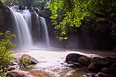
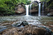
- Khao Yai National Park is in the western part of the Sankamphaeng Mountain Range, at the southwestern boundary of the Khorat Plateau. The highest mountain in the area of the park is 1,351 m high Khao Rom. This park lies largely in Nakhon Ratchasima province (Khorat), but also includes parts of Saraburi, Prachinburi, and Nakhon Nayok provinces. The park is the third largest in Thailand. It covers an area of 300 square kilometers, including tropical seasonal forests and grasslands. Elevations mostly range from 400 to 1,000 m. It is home to 3,000 species of plants and 320 species of birds. Waterfalls include the 80 metre Heo Narok, and Heo Suwat .
-
 Elephant at Khao Yai National Park
 -
 Khao Yai National Park
 -
 Khao Yai National Park
 -
 Waterfall in Khao Yai National Park
 -
 Pha Diao Dai ("Lonely Cliff"), Khao Yai National Park
 -
 Wild elephants walking up a road in the area of Khao Yai National Park
 -
 Heo Suwat Waterfall, Khao Yai National Park
 -
 An oriental pied hornbill (Anthracoceros albirostris) in Khao Yai National Park
 -
 Heo Narok Waterfall, Khao Yai National Park
 -
 A butterfly near Heo Narok Fall, Khao Yai National Park

.jpg)


- Nakhon Ratchasima railway station is a 1st class station and the main railway station in the province. There are 18 daily trains serving this station. There are four to six special trains during the celebration of the New Year and Songkran.
- Lam Takhong Dam is an embankment dam on the Lam Takhong River between Pak Chong District and Sikhio District. The dam was constructed in 1974 for the purposes of irrigation and water supply, but after 2002 its water storage also serves as the lower reservoir for the Lam Takhong pumped storage power plant, Thailand's first power plant of this type.
- Korat's zoo was established under the patronage of the king. The zoo is managed by the Ministry of Natural Resources and Environment (Thailand). The Korat Zoo has rare animals such as tigers, giraffes, lions, elephants, zebras, rhinoceroses, hedgehogs, birds such as guinea fowls, ostriches, and flamingos.
- Khao Yai Thiang is the mountain located in Khlong Phai, Pak Chong District. There are 12 wind turbines on top of the mountain. Tourist can go cycling and enjoying the view of reservoir.
Korat cat[edit]

(Thai: โคราช, มาเลศ, สีสวาด, RTGS: Khorat, malet, si sawat)
The Korat cat is a natural breed, and one of the oldest stable cat breeds. Originating in Nakhon Ratchasima province at Phimai,[13] it is named after its province of origin. In Thailand the breed is known as si sawat, meaning "colour of the sawat seed" (bluish-gray). Korat cats are distinguished not only by the colour of their fur. Genuine Korat cats have a heart-shaped face when viewed from any angle and shorter grey hair with silver tips. The true breed's eyes are yellow with an inner green circle. They must be slender and agile. The cat's tail must be slender. Cats with crooked tails are considered inauspicious.[13]
In 1965, Korat cats were first registered in the US by the Korat Cat Fanciers Association. The cats that formed the breed were first imported from Thailand by Jean L. Johnson in 1959. In 1966 the breed was accepted by the Cat Fanciers' Association (CFA). The Korat breed is now accepted by cat associations around the world.[13]
The International Maew Boran Association (TIMBA) ("maew boran" means "ancient cat") was formed in Thailand to provide a registry of and pedigrees for Thai cats, including Korats, and to provide a voice in English for Thai breeders as "...Thai breeders...do not speak English, and farang breeders do not speak Thai.".[14][13]
References[edit]
- ^ "รายนามผู้ว่าราชการจังหวัด" [List of Governors of Provinces of Thailand] (PDF). Ministry of Interior (Thailand). 2 December 2022. Retrieved 8 January 2023.
- ^ a b "ตารางที่ 2 พี้นที่ป่าไม้ แยกรายจังหวัด พ.ศ.2562" [Table 2 Forest area Separate province year 2019]. Royal Forest Department (in Thai). 2019. Retrieved 6 April 2021, information, Forest statistics Year 2019, Thailand boundary from Department of Provincial Administration in 2013.
- ^ a b รายงานสถิติจำนวนประชากรและบ้านประจำปี พ.ส.2562 [Statistics, population and house statistics for the year 2019]. Registration Office Department of the Interior, Ministry of the Interior. stat.bora.dopa.go.th (in Thai). 31 December 2019. Retrieved 26 February 2020.
- ^ a b "ข้อมูลสถิติดัชนีความก้าวหน้าของคน ปี 2565 (PDF)" [Human Achievement Index Databook year 2022 (PDF)]. Office of the National Economic and Social Development Council (NESDC) (in Thai). Retrieved 12 March 2024, page 34
{{cite web}}: CS1 maint: postscript (link) - ^ "Gross Regional and Provincial Product, 2019 Edition". <>. Office of the National Economic and Social Development Council (NESDC). July 2019. ISSN 1686-0799. Retrieved 22 January 2020.
- ^ a b c d Janssen, Peter (2 November 2016). "Thailand takes a long-term gamble on Isaan region". Nikkei Asian Review. Retrieved 3 November 2016.
- ^ a b "ข้อมูลพื้นที่อุทยานแห่งชาติ ที่ประกาศในราชกิจจานุบกษา 133 แห่ง" [National Park Area Information published in the 133 Government Gazettes]. Department of National Parks, Wildlife and Plant Conservation (in Thai). December 2020. Retrieved 1 November 2022.
- ^ "Thai People In Northeastern Thailand (Isan)". Archived from the original on 11 August 2014. Retrieved 2 September 2011.
- ^ "Number of local government organizations by province". dla.go.th. Department of Local Administration (DLA). 26 November 2019. Retrieved 10 December 2019.
20 Nakhon Ratchasima: 1 PAO, 1 City mun., 4 Town mun., 85 Subdistrict mun., 243 SAO.
- ^ Temphairojana, Pairat (10 February 2015). "Seagate to invest $470 mln in Thailand over next 5 years". Reuters. Retrieved 3 November 2016.
- ^ "MNRH".
- ^ "Welcome to WIS". Wesley International School. Retrieved 7 November 2016.
- ^ a b c d Na Thalang, Jeerawat (6 November 2016). "Splitting hairs over cat breeds". Bangkok Post. Retrieved 8 November 2016.
- ^ "Welcome to TIMBA". TIMBA: The International Maew Boran Association. Retrieved 10 November 2016.
External links[edit]
 Nakhon Ratchasima travel guide from Wikivoyage
- Province page from the Tourist Authority of Thailand
- Nakhon Ratchasima Travel Guide
- Official website
- Nakhon Ratchasima provincial map, coat of arms and postal stamp Archived January 3, 2015, at the Wayback Machine
- Khao Yai National Park
Places adjacent to Nakhon Ratchasima province | |
|---|---|
Nakhon Ratchasima (capital) | ||
| Districts (amphoe) |
|  |
| Cities and Towns | ||
| Sports | ||
| Natural Sights | ||
| Historical Sights | ||
| Transports |
| |
Tourism in Nakhon Ratchasima Province | ||
|---|---|---|
| City of Nakhon Ratchasima |  | |
| Upper section | ||
| Lower section | ||
14°58′20″N 102°6′0″E / 14.97222°N 102.10000°E
| International | |
|---|---|
| National | |
| Geographic | |
| Other | |