
Queenstown, New Zealand
Queenstown
Tāhuna (Māori) | |
|---|---|
.jpg) Queenstown from Bob's Peak | |
 | |
| Coordinates: 45°01′52″S 168°39′45″E / 45.03111°S 168.66250°E | |
| Country | |
| Region | Otago |
| Territorial authority | Queenstown-Lakes District |
| Named | January 1863 [1] |
| Founded by | William Gilbert Rees |
| Electorates | Southland Te Tai Tonga |
| Government | |
| • Mayor | Glyn Lewers |
| • MPs | |
| Area | |
| • Urban | 86.61 km2 (33.44 sq mi) |
| Population (June 2023) | |
| • Urban | 29,000 |
| • Urban density | 330/km2 (870/sq mi) |
| • District | 52,800 |
| Time zone | UTC+12:00 (NZST) |
| • Summer (DST) | UTC+13:00 (NZDT) |
| Postcode(s) | 9300 |
| Area code | 03 |
| Local iwi | Ngāi Tahu |
Queenstown (Māori: Tāhuna)[3] is a resort town in Otago in the south-west of New Zealand's South Island. It has an urban population of 29,000 (June 2023).[4]
The town is built around an inlet called Queenstown Bay on Lake Wakatipu, a long, thin, Z-shaped lake formed by glacial processes, and has views of nearby mountains such as The Remarkables, Cecil Peak, Walter Peak and just above the town, Ben Lomond and Queenstown Hill.
The Queenstown-Lakes District has a land area of 8,704.97 square kilometres (3,361.01 sq mi) not counting its inland lakes Hāwea, Wakatipu, and Wānaka. The region has an estimated resident population of 52,800 (June 2023).[4] Neighbouring towns include Arrowtown, Glenorchy, Kingston, Wānaka, Alexandra, and Cromwell. The nearest cities are Dunedin and Invercargill. Queenstown is known for its tourism businesses, especially adventure and ski tourism.
Toponymy[edit]
Tāhuna, the te reo name for Queenstown, means "shallow bay".[5]
There are various apocryphal accounts of how Queenstown gained its name, of which the following appears to be the most likely: "When William Rees first arrived in the area and built his homestead, the area was known as The Station although miners soon referred to it as The Camp from 1860 to 1862. The miners, and especially the Irish, had taken an interest in the ceremony held for a town called Cobh in Ireland (then part of the United Kingdom) which was renamed Queenstown in honour of Queen Victoria in 1850.[6]
There was then a public meeting to name the township on the lake in January 1863 (probably the weekend of the 3rd and 4th) in which the town was officially given the name of Queenstown in reference to Ireland's Queenstown. By 9–10 January 1863, the town was being reported with the name of Queenstown in several reports written by a correspondent in the Otago Witness on 5 and 6 January.[7][8]
History[edit]
Māori settlement and presence[edit]
The area was discovered and first settled by Māori. Kāi Tahu say that the lake was dug by the Waitaha ancestor, Rākaihautū, with his kō (digging stick) named Tūwhakaroria. After arriving at Whakatū Nelson in the waka Uruao, Rākaihautū divided his crew into two. He led one group through the interior of Te Waipounamu, digging the freshwater lakes of the island. After digging the lakes Hāwea, Wānaka, and Whakatipu Waimāori, he travelled through the Greenstone and Hollyford valleys before finally digging Whakatipu Waitai (Lake McKerrow).[9]
The first non-Māori to see Lake Wakatipu was European Nathanael Chalmers who was guided by Reko, the chief of the Tuturau, over the Waimea Plains and up the Mataura River in September 1853.[10] Evidence of stake nets, baskets for catching eels, spears and ashes indicated the Glenorchy area was visited by Māori. It is likely Ngāi Tahu Māori visited Queenstown en route to collect Pounamu (greenstone). A settlement called Te Kirikiri Pa was occupied by the tribe of Kāti Māmoe which was situated where the Queenstown Gardens are today, but by the time European migrants arrived in the 1860s this settlement was no longer being used.[5]
European settlement c. 1860[edit]
European explorers William Gilbert Rees and Nicholas von Tunzelmann were the first non-Māori to settle the area. Rees established a high country farm in the location of Queenstown's current town centre in 1860, but the discovery of gold in the Arrow River in 1862 encouraged Rees to convert his wool shed into a hotel named the Queen's Arms, now known as Eichardt's.[11]
Many Queenstown streets bear names from the gold mining era (such as Camp Street) and some historic buildings remain. William's Cottage, the Lake Lodge of Ophir (now Artbay Gallery), Queenstown Police Station, and St Peter's Anglican Church lie close together in a designated historic precinct.
1999 flooding[edit]
There was a severe weather event in the South Island in November 1999, bringing torrential rainfall in the catchments of Lake Wakatipu.[12] The level of the lake rose from 310.5 m to 312.77 m, leading to the most severe flooding in the recorded history of Queenstown. Properties in central Queenstown close to the lakeshore were flooded up to 1 m deep, causing major damage. Total insurance claims were around $50 million. Properties in Glenorchy and Kingston were also flooded, and the road from Queenstown to Glenorchy was damaged by washouts.[13][14]
Geography[edit]
Queenstown is situated on the shore of Lake Wakatipu, the third largest lake by surface area in New Zealand. The town is located close to the lake's northeastern bend, at which point a small arm, the Frankton Arm, joins the lake with its principal outflow, the Kawarau River. The centre of the town is on the north shore at the point where the Frankton Arm links with the main body of the lake, but also extends to the major suburb of Frankton at the eastern end of the arm, and across to Kelvin Heights on the Kelvin Peninsula, which forms the Frankton Arm's southern shore.
The town is at a relatively low altitude for a ski and snowboarding centre, at 310 metres (1,020 ft) above sea level at the lake shore, but is nestled among mountains, most notably the scenic attraction of The Remarkables, to the town's southeast. Below the lake lies the deep Kawarau Gorge, and there are nearby plains suitable for agriculture[citation needed] and viticulture. Queenstown lies close to the heart of the Central Otago wine region.
Suburbs[edit]
Central Queenstown contains many businesses, apartments and homes but is near many suburbs or large areas of housing: Fernhill, Sunshine Bay, Queenstown Hill, Goldfield Heights, Marina Heights, Kelvin Heights, Arthurs Point and Frankton.
Just outside Queenstown are the areas of: Arrowtown, Closeburn, Dalefield, Gibbston, Jack's Point, Hanley's Farm, Hayes Creek, Lake Hayes Estate, Shotover Country and Quail Rise.
.jpg)
Climate[edit]
Because of its relatively moderate altitude (310 metres) and high mountain surroundings, Queenstown has an oceanic climate (Köppen climate classification Cfb).[15] Summer has long warm days with temperatures that can reach 30 °C while winters are cold with temperatures often in single digits with frequent snowfall, although there is no permanent snow cover during the year. As with the rest of Central Otago, Queenstown lies within the rain shadow of the Southern Alps, but being closer to the west coast the town is more susceptible to rain-bearing fronts than nearby Cromwell, Wānaka and Alexandra. The hottest recorded temperature in Queenstown is 34.1 °C (93 °F), while the coldest is −8.4 °C (17 °F).[16]
| Climate data for Queenstown Airport (1981–2010), extremes (1968–present) | |||||||||||||
|---|---|---|---|---|---|---|---|---|---|---|---|---|---|
| Month | Jan | Feb | Mar | Apr | May | Jun | Jul | Aug | Sep | Oct | Nov | Dec | Year |
| Record high °C (°F) | 33.4 (92.1) |
32.2 (90.0) |
30.0 (86.0) |
25.1 (77.2) |
21.3 (70.3) |
19.4 (66.9) |
17.0 (62.6) |
19.7 (67.5) |
23.3 (73.9) |
26.0 (78.8) |
28.5 (83.3) |
30.0 (86.0) |
33.4 (92.1) |
| Mean daily maximum °C (°F) | 21.7 (71.1) |
21.5 (70.7) |
18.7 (65.7) |
15.1 (59.2) |
11.5 (52.7) |
8.3 (46.9) |
7.7 (45.9) |
9.9 (49.8) |
12.9 (55.2) |
15.3 (59.5) |
17.6 (63.7) |
19.8 (67.6) |
15.0 (59.0) |
| Daily mean °C (°F) | 15.7 (60.3) |
15.4 (59.7) |
13.0 (55.4) |
9.6 (49.3) |
6.7 (44.1) |
3.9 (39.0) |
3.1 (37.6) |
5.0 (41.0) |
7.6 (45.7) |
9.8 (49.6) |
11.9 (53.4) |
14.1 (57.4) |
9.7 (49.5) |
| Mean daily minimum °C (°F) | 9.7 (49.5) |
9.3 (48.7) |
7.3 (45.1) |
4.2 (39.6) |
2.0 (35.6) |
−0.6 (30.9) |
−1.6 (29.1) |
0.1 (32.2) |
2.3 (36.1) |
4.3 (39.7) |
6.2 (43.2) |
8.4 (47.1) |
4.3 (39.7) |
| Record low °C (°F) | 0.3 (32.5) |
0.5 (32.9) |
−1.6 (29.1) |
−4.5 (23.9) |
−8.8 (16.2) |
−10.3 (13.5) |
−8.9 (16.0) |
−7.8 (18.0) |
−5.0 (23.0) |
−4.2 (24.4) |
−2.1 (28.2) |
−0.4 (31.3) |
−10.3 (13.5) |
| Average precipitation mm (inches) | 63.9 (2.52) |
48.1 (1.89) |
52.7 (2.07) |
56.0 (2.20) |
70.1 (2.76) |
72.1 (2.84) |
49.2 (1.94) |
68.7 (2.70) |
66.8 (2.63) |
65.6 (2.58) |
67.6 (2.66) |
76.4 (3.01) |
757.2 (29.81) |
| Average precipitation days (≥ 1.0 mm) | 7.2 | 6.2 | 7.4 | 7.4 | 9.0 | 9.2 | 6.9 | 9.1 | 8.5 | 8.8 | 7.6 | 9.6 | 96.9 |
| Average relative humidity (%) | 70.2 | 74.3 | 75.8 | 78.4 | 81.1 | 83.8 | 83.3 | 80.5 | 73.1 | 70.9 | 67.5 | 69.4 | 75.7 |
| Mean monthly sunshine hours | 230.3 | 207.3 | 187.0 | 145.4 | 87.8 | 71.8 | 88.3 | 120.0 | 153.6 | 197.7 | 216.6 | 223.5 | 1,929.2 |
| Source 1: NIWA Climate Data[17] | |||||||||||||
| Source 2: CliFlo[18][19] | |||||||||||||
Flood risk[edit]
Low-lying areas of Queenstown that are close to Lake Wakatipu are at risk of flooding because during heavy rain and snowmelt, the outflows of the lake via the Kawarau River are less than the inflows and the lake level can rise significantly. Further, the outflow down the Kawarau River is impeded by the large delta of the Shotover River – a major tributary. There is also a narrow gorge that restricts flow in the Kawarau river. As a consequence, Queenstown has been flooded several times since its establishment, and there is an on-going risk of flooding in low-lying areas.[20] As the lake level rises, backflow through the town's stormwater system leads to flooding in some Queenstown streets when the lake level reaches 311.3 m. This has occurred around 20 times since 1878. In any one year, there is a 13 percent chance that the lake will reach this level, and a 75 percent chance of at least one event that exceeds this level in a 10 year period.[21]
Demography[edit]
Queenstown is described by Statistics New Zealand as a medium urban area with an area of 86.61 km2 (33.44 sq mi).[2] It had an urban population of 29,000 (June 2023),[4] making it the 24th-largest urban area in New Zealand. In 2016, Queenstown overtook Oamaru to become the second-largest urban area in Otago, behind Dunedin. Prior to 2023, the Queenstown urban area as defined by Statistics New Zealand didn't include Lake Hayes or Arthurs Point, which are contiguous with Queenstown but were designated as separate urban areas.
| Year | Pop. | ±% p.a. |
|---|---|---|
| 2006 | 10,428 | — |
| 2013 | 11,334 | +1.20% |
| 2018 | 13,539 | +3.62% |
| Source: [22] | ||
The Queenstown urban area had a population of 13,539 at the 2018 New Zealand census, an increase of 2,205 people (19.5%) since the 2013 census, and an increase of 3,111 people (29.8%) since the 2006 census. There were 4,254 households. There were 7,089 males and 6,447 females, giving a sex ratio of 1.1 males per female, with 1,341 people (9.9%) aged under 15 years, 4,887 (36.1%) aged 15 to 29, 6,264 (46.3%) aged 30 to 64, and 1,041 (7.7%) aged 65 or older.
Ethnicities were 71.2% European/Pākehā, 4.5% Māori, 1.2% Pacific peoples, 17.8% Asian, and 10.5% other ethnicities (totals add to more than 100% since people could identify with multiple ethnicities).
The proportion of people born overseas was 58.3%, compared with 27.1% nationally.
Although some people objected to giving their religion, 58.5% had no religion, 29.1% were Christian, 2.8% were Hindu, 0.6% were Muslim, 1.7% were Buddhist and 3.4% had other religions.
Of those at least 15 years old, 3,234 (26.5%) people had a bachelor or higher degree, and 759 (6.2%) people had no formal qualifications. 1,692 people (13.9%) earned over $70,000 compared to 17.2% nationally. The employment status of those at least 15 was that 9,165 (75.1%) people were employed full-time, 1,263 (10.4%) were part-time, and 138 (1.1%) were unemployed.[22]
| Name | Area (km2) | Population | Density (per km2) | Households | Median age | Median income |
|---|---|---|---|---|---|---|
| Frankton | 7.62 | 2,895 | 380 | 1,017 | 32.8 years | $39,300[23] |
| Frankton Arm | 1.20 | 1,917 | 1,598 | 603 | 31.2 years | $41,200[24] |
| Kelvin Heights | 9.28 | 1,170 | 126 | 447 | 43.4 years | $44,800[25] |
| Queenstown Central | 0.81 | 1,017 | 1,256 | 261 | 30.0 years | $34,300[26] |
| Quail Rise | 6.27 | 708 | 113 | 234 | 40.5 years | $49,200[27] |
| Queenstown East | 0.98 | 1,416 | 1,445 | 441 | 30.5 years | $38,800[28] |
| Sunshine Bay-Fernhill | 1.31 | 2,931 | 2,237 | 861 | 29.6 years | $37,600[29] |
| Warren Park | 0.94 | 1,485 | 1,580 | 390 | 28.7 years | $34,200[30] |
| New Zealand | 37.4 years | $31,800 |
Economy[edit]
The economy of Queenstown is a major contributor to the economy of the Queenstown Lakes District, although the district covers a much wider area than Queenstown, and includes the towns of Wānaka to the north-east, Glenorchy to the north-west and Kingston to the south.
Housing[edit]
Residential housing in the Queenstown area is expensive due to factors such as the town being a tourist destination, its lack of land and its desirability to foreigners and investors. Queenstown is rated the least affordable place in New Zealand to buy a property, overtaking Auckland at the start of 2017.[31][32] In December 2016 the average house price in the Queenstown area rose to $1 million NZD.[33] Between 2016 and 2019, average rents in Queenstown rose progressively; reaching 10.8% in 2016, 16% in 2017, and 7.4% in 2018, and 9.6% in 2019. 2018 census data showed 27 percent of Queenstown homes were marked as unoccupied.[34]
During the early 2020s, Queenstown experienced a decline in rental housing. Between December 2021 and December 2022, the online auction platform Trade Me reported a 49% decline in rental listings across the Queenstown-Lakes District. Similarly, the Ministry of Business, Innovation and Employment (MBIE) reported that the number of rental houses in the District had dropped by 100 between November 2021 and November 2022. Despite a building boom in 2022, Stuff reported that 27% of homes in the Lakes District were unoccupied since their owners preferred to use them as holiday homes or short-term accommodation rather than rentals[35] By November 2022, Radio New Zealand reported that the average home in the Lakes District cost NZ$1.7 million while a three-bedroom rental cost a minimum of NZ$800 per week and a single bedroom rental NZ$500 or more per week.[36][37]
In October 2022, Environment Minister David Parker confirmed that the New Zealand Government had fast-tracked the Te Pūtahi project at Lake Hayes Estate to build 748 more homes, a public transport area, and a possible school.[38]
By early 2023, Stuff, Radio New Zealand, and The New Zealand Herald reported that a shortage of rental housing had forced many workers and businesspeople to sleep in cars, couches, tents, visitor hostels, and others to leave the town. In addition, the housing shortage had contributed to a worker shortage among local businesses since they had trouble attracting foreign visa workers or those from outside Queenstown.[39][40][34] The Herald also reported that some workers in Queenstown were asking local rental agents if they could stay in vacant properties being sold.[34] In late March 2023, 100 people participated in a protest at Queenstown's waterfront to raise awareness of the resort town's acute rental housing shortage. The protest was attended by National Party Southland electorate Member of Parliament Joseph Mooney and Queenstown Lakes District Councillor Craig Ferguson.[41]
Employment[edit]
The area’s growth rate is one of the fastest in the country with the population growing 7.1% from 2015 to 2016 in a 12-month period. Most jobs in Queenstown are tourism- or accommodation-related. Employment growth was also the highest of any area in New Zealand at 10.3% in the March 2016 year.[42]
Retail[edit]
Queenstown has a tourist-focused shopping area, centred around the Queenstown Mall. The public pedestrian street opened in 1990,[43] and includes Reading Cinemas.[44]
O'Connells Shopping Centre also opened in 1990,[43] and is due to undergo an upgrade in 2021.[45]
In 1986, Queenstown was granted an exemption to allow shops to open every day of the year except Christmas Day, Easter Sunday and before 12 noon on Anzac Day (at the time, shops in New Zealand were required to close on Sundays and public holidays). The exemption was extended in 1990 allow shops to open on Easter Sunday. The exemption applies to all shops in a 35-kilometre (22 mi) radius of the intersection of Camp Street and Ballarat Street in central Queenstown, and makes Queenstown and the Lake Wakatipu basin one of only three areas in New Zealand where shops may open on Good Friday (the other two are Picton and Paihia).[46]
Government[edit]
Local[edit]
Queenstown lies in the Queenstown-Lakes District territorial authority. It is also part of the Otago region, administered by the Otago Regional Council.
National[edit]
For the New Zealand Parliament, Queenstown is covered by one general electorate, Southland, and one Maori electorate, Te Tai Tonga. As of the 2023 general election, Southland is represented by Joseph Mooney (National) and Te Tai Tonga is represented by Tākuta Ferris (Te Pāti Māori).
Tourism[edit]


Tourism is a large component of the Queenstown economy, particularly outdoor and adventure tourism activities including skiing and snowboarding, jet boating, whitewater rafting, bungy jumping, mountain biking, skateboarding, tramping, paragliding, sky diving and fly fishing.[47]
Queenstown is a major centre for snow sports in New Zealand, with four main mountain ski fields: Cardrona Alpine Resort, Coronet Peak, The Remarkables and Treble Cone. Cross country skiing is also available at the Waiorau Snow Farm, near Cardrona village.[48]
A heritage steamship, the twin screw coal fired steamer TSS Earnslaw operates on Lake Wakatipu.[49]
Queenstown lies close to the centre of the world's southernmost wine region, the Central Otago wine region, which has a growing international reputation for its quality Pinot Noir.[50][51][52] The Two Paddocks vineyard is owned by internationally known New Zealand actor Sam Neill, and neighbouring, historic Arrowtown features restaurants and bars.[53]
Other tourist activities include Ben Lomond, a nearby mountain with a panoramic outlook on Bob's Peak, and its Skyline Queenstown gondola.[54] Queenstown hosts the Kiwi Park wildlife sanctuary, and Paradise is a nearby rural location known for its paradise duck population (Tadorna variegata).[55] The Queenstown Trail and Skippers Road are popular walking, running, and mountain-biking tracks.[56]
Culture[edit]
Festivals[edit]
Queenstown has many festivals.[57] Examples include the ten-day Bike Festival held in January,[58] Winter Festival (June),[59] Jazz Festival (October),[60] and Winter Pride (August–September) which is the largest winter pride event in the Southern Hemisphere.[61]
Locations for television and film[edit]
Jane Campion's six-part drama mystery Top of the Lake was shot during 2012 for pay TV release in 2013. The lakes of the Wakatipu appear ominous,[62] and the Southern Alps spectacular. The main location is Moke Lake[63][64] and scenes were shot on Lower Beach Street and Coronation Drive, and at a supermarket and bottle store on Shotover Street.[63]
In 2010, Cycle 14 of America's Next Top Model, was, in part filmed in Queenstown and was as won by Krista White. Raina Hein was runner-up.
Queenstown and the surrounding area contain many locations used in the filming of The Lord of the Rings film trilogy. Locations used include Paradise near Glenorchy, at the head of Lake Wakatipu.
Queenstown became popular in South Asia after the release of Bollywood blockbuster Kaho Naa... Pyaar Hai, which was partially shot there. Starring sensational debuts by Hrithik Roshan and Amisha Patel it was this film that opened the doors for both tourists and filmmakers from India to New Zealand with Queenstown being the most sought-after destination. Queenstown featured for 17 minutes in I Hate Luv Storys, a 2010 Bollywood romantic comedy. Queenstown and the surrounding areas were also used in the 2009 X-Men Origins: Wolverine film. Mee-Shee: The Water Giant was shot in Queenstown in 2005, and released to DVD in the same year. Queenstown was also used to film most of the 1988 The Rescue. Queenstown was the base for filming the George Lucas 1988 fantasy film Willow.
Filming of the 1981 film Race for the Yankee Zephyr took place in and around Queenstown, the first major motion picture production for the area.
A 1989 TV Commercial for the Toyota Hilux starring Barry Crump and Lloyd Scott in which the two drive off the cliff was filmed at nearby Queenstown Hill. [65]
The first and last episodes of the fifth season of The Mole were filmed in Queenstown.
The 2017 Filipino drama film Northern Lights was shot entirely on location in Queenstown substituting for the setting of Alaska.[66]
In 2017 the Korean variety show Running Man shot an episode in Queenstown, where Haha and Yang-Se Chan took a penalty at the Nevis Swing.[67]
The 2020 crime drama One Lane Bridge was filmed in Queenstown. The series focuses on events that take place at a bridge over the Dart River / Te Awa Whakatipu.[68]
Sports and recreation[edit]
- Queenstown Events Centre and stadium
- Paragliding or Hang Gliding[69]
- Aerobatics[70] with the Wakatipu Aero Club[71] at Queenstown Airport at Frankton
- Golf at Millbrook Resort, Jack's Point,[72] or Queenstown Golf Club[73]
- Disc golf[74][75] at the Queenstown Gardens
- Tennis at the Queenstown Tennis Club[76] in Queenstown Gardens
- Cricket at the Queenstown Cricket Club[77]
- Netball at the Wakatipu Netball Centre[78]
- Rugby league and Rugby union at the Wakatipu Rugby League Club[79][80] Memorial Park
- Touch rugby[81] during the summer season[82]
- Scuba diving or snorkeling in a river, bridge wreck, or in Lake Wakatipu[83]
- Adventure sport, canyon-swing, parachute, jetboat, bungy jump, river-surf, or kitesurf
In the area[edit]
- Central Otago region
- Central Otago wine region
- History of the Central Otago Gold Rush
- Fiordland National Park, including the Milford Road and Homer Tunnel to Milford Sound / Piopiotahi, as well as the Fiordland Lakes and Doubtful Sound / Patea
- Tramping track near Glenorchy
- Routeburn,[84] one of the New Zealand Great Walks


Education[edit]
Primary schools[edit]
Queenstown Primary School is a co-educational state primary school for Year 1 to 8 students,[85][86] with a roll of 563 as of February 2024.[87]
St Joseph's School is a co-educational Catholic state-integrated primary school for Year 1 to 8 students,[88][89] with a roll of 134.[90]
There are also two primary schools in Frankton and a school in Shotover Country.[91]
Secondary schools[edit]
Wakatipu High School, a state secondary school for Year 9 to 13 students, is located in Frankton.[92]
Tertiary education[edit]
Southern Institute of Technology (SIT), based in Invercargill, has a campus in Queenstown.[93]
Queenstown Resort College is a tertiary education provider focussing on tourism. The college actively supports events for international travel agents.[94]
ACE Wakatipu has a community focus, and provides links to many adult training opportunities.[95]
Churches[edit]
Saint Andrew's church[edit]
Saint Andrew's Presbyterian church was completed in 1968 to replace the previous church which was sold and demolished to reuse the land. The church is designed to seat 350 parishioners. The Presbyterian church has been active in the Wakatipu area since 1865.[96]
Saint Peter's church[edit]
Saint Peter's Anglican church was built in 1932 for a cost of 2862 pounds, it was consecrated on 23 November 1932. It replaced the previous wooden church which was built in 1863.[97]
Saint Joseph's church[edit]
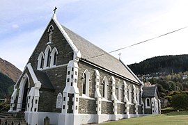
Saint Joseph's Catholic church was built in 1898, it replaced the first catholic church built in Queenstown in 1863. It is built from schist sourced from Arthur's Point. Built in the Gothic Revival style, it was designed by the architect Francis Petre. It is a category two historic place.[98]
- Queenstown churches
-
 Saint Joseph's Catholic Church
 -
 Saint Peter's Anglican Church
 -
 Interior of Saint Peter's Anglican Church
 -
 Saint Andrew's Presbyterian Church


Infrastructure[edit]
Transport[edit]
Queenstown is accessible by road and air but not by rail (similar to Kaitaia, Taupō and Nelson).
As a resort centre, many bus services operate into Queenstown, mostly for package tours, but daily services for locals and others are available to and from Invercargill, Dunedin and Christchurch, the main cities closest to Queenstown. Bee Cards replaced GoCards on local buses on 15 September 2020.[99]
Queenstown Airport takes flights from Australia by airlines Air New Zealand, Qantas, Virgin Australia and Jetstar and has destinations that include Brisbane, Gold Coast, Melbourne and Sydney (the frequency is much increased over the ski season and during summer). Domestic flights fly to Auckland, Christchurch and Wellington. Queenstown Airport is New Zealand's busiest helicopter base, also the fourth-busiest airport by passenger traffic, and is also heavily used for tourist 'flightseeing', especially to Milford Sound / Piopiotahi and Aoraki / Mount Cook, using both fixed-wing and rotary-wing aircraft.
The primary road access to the Queenstown area is via State Highway 6 (SH6), from Cromwell through the Kawarau Gorge to Frankton, where a 9 km spur (SH6A) leads to the CBD and connects with the Glenorchy Road. SH6 continues south, crossing the Kawarau river before heading down the eastern side of Lake Wakatipu to Kingston before crossing the provincial boundary and emerging on the plains of Southland, terminating in the city of Invercargill. A difficult road over the Crown Range leads to Cardrona skifield and Wānaka, and is New Zealand's highest paved public road pass.[100]
Queenstown is the departure point for a large number of bus day trips to Milford Sound, which entails a return trip of approximately 12 hours. There are scenic flights available to and from Milford Sound. A return flight, including a two-hour cruise, is approximately four hours.
Utilities[edit]
In September 2023, there was an outbreak of illness caused by cryptosporidium in Queenstown, with most cases located in the central business area and affecting people under the age of 40. Health officials were unable to immediately link the cases, or identify the source of the outbreak, and described the outbreak as very unusual.[101] A "boil water" notice was issued for all water supplies across Queenstown.[102][103] The regulator Taumata Arowai issued a compliance order to the Queenstown Lakes District Council for one of its water treatment plants, because it did not have a protozoa barrier to prevent cryptosporidium entering the water supply.[104]
Electricity distribution in Queenstown is the responsibility of two companies, Dunedin-based Aurora Energy and Invercargill-based Powernet. Electricity is supplied from Transpower's national grid at its substation in Frankton, which in turn is fed by a twin-circuit 110,000-volt line from Transpower's Cromwell substation.[105]
Queenstown was one of the last towns in New Zealand with a manual telephone exchange, whereby all calls had to be connected by an operator. The town was upgraded to a fully automatic exchange in 1988.[106] Fibre to the premises was rolled-out in Queenstown as part of the Fifth National Government's Ultra-Fast Broadband programme, with the rollout completed in July 2016.[107]
Notable people[edit]
- Sam Neill (born 1947), actor, has a home in Queenstown
- Tim Bevan (born 1957), film producer, was born in Queenstown
- Jaime Passier-Armstrong (born 1981), actress, was born in Queenstown
- Jane Taylor, lawyer and current Chair of New Zealand Post, lives in Queenstown
- Kim Dotcom, internet entrepreneur
Sister cities[edit]
- Aspen, Colorado, United States[108]
- Hangzhou, Zhejiang[109][110]
- Hikimi, Shimane (now a part of Masuda), Japan[110]

See also[edit]
Bibliography[edit]
- Reed, A. W. (2002). The Reed Dictionary of New Zealand Place Names. Auckland, New Zealand: Reed Books. ISBN 0-7900-0761-4.
References[edit]
- ^ Jardine, D.G. (1978). Shadows on the Hill. A.H. & A.W. Reed Ltd. p. 187. ISBN 0589010093.
- ^ a b "ArcGIS Web Application". statsnz.maps.arcgis.com. Archived from the original on 24 March 2023. Retrieved 24 December 2021.
- ^ "Queenstown". Victoria University. Archived from the original on 26 September 2015. Retrieved 2 September 2015.
- ^ a b c "Subnational population estimates (RC, SA2), by age and sex, at 30 June 1996-2023 (2023 boundaries)". Statistics New Zealand. Retrieved 25 October 2023. (regional councils); "Subnational population estimates (TA, SA2), by age and sex, at 30 June 1996-2023 (2023 boundaries)". Statistics New Zealand. Retrieved 25 October 2023. (territorial authorities); "Subnational population estimates (urban rural), by age and sex, at 30 June 1996-2023 (2023 boundaries)". Statistics New Zealand. Retrieved 25 October 2023. (urban areas)
- ^ a b "Spiritual bond to first people". Otago Daily Times. 6 February 2009. Archived from the original on 24 September 2015. Retrieved 6 September 2015.
- ^ "Queenstown". New Zealand History. Archived from the original on 11 September 2015. Retrieved 25 August 2015.
- ^ "The Dunstan". Otago Witness. 5 January 1863. Archived from the original on 30 September 2020. Retrieved 24 August 2015.
- ^ "The Dunstan". Otago Witness. 6 January 1863. Archived from the original on 30 September 2020. Retrieved 24 August 2015.
- ^ "Atlas — Cultural Mapping Project — Te Rūnanga o Ngāi Tahu". www.kahurumanu.co.nz. Archived from the original on 18 October 2022. Retrieved 18 October 2022.
- ^ Miller., F.W.G., (1949), Golden Days of Lake County. Whitcombe and Tombs. p 3-11.
- ^ "Queenstown history – William Gilbert Rees". Archived from the original on 8 March 2012. Retrieved 21 June 2012.
- ^ "November 1999 South Island Flooding (1999-11-14 )". NIWA. Retrieved 1 January 2024.
- ^ Quinn, Rowan (28 April 2005). "Queenstown should get used to this...; `No way to stop floods'". The Southland Times. ProQuest 330815524.
- ^ Roxburgh, Tracey (25 November 2009). "Flood of 1999 remembered". Otago Daily Times Online News. Retrieved 1 January 2024.
- ^ "Statistics for NZL Queenstown". Department of Energy. 2010. Archived from the original on 31 October 2011. Retrieved 6 June 2011.
- ^ "Summary Climate Information for Selected New Zealand Locations". NIWA. Archived from the original on 24 May 2010.
- ^ "Climate Data and Activities". NIWA. 28 February 2007. Archived from the original on 10 October 2013. Retrieved 19 October 2013.
- ^ "The National Climate Database". NIWA. Archived from the original on 10 October 2019. Retrieved 13 June 2022.
- ^ "93831: Queenstown Aerodrome (New Zealand)". ogimet.com. OGIMET. 4 August 2022. Archived from the original on 4 April 2023. Retrieved 8 August 2022.
- ^ Forsyth, Jane; Clark, Elizabeth; Becker, Julia (March 2005). "1999 Queenstown Floods" (PDF). Planning Quarterly. Ministry for the Environment.
- ^ "Lake Wakatipu flood hazard: Queenstown CBD" (PDF). Otago Regional Council. Retrieved 1 January 2024.
- ^ a b "Statistical area 1 dataset for 2018 Census". Statistics New Zealand. March 2020. Frankton (348400), Frankton Arm (348300), Kelvin Heights (348600), Queenstown Central (348100), Quail Rise (348000), Queenstown East (348200), Sunshine Bay-Fernhill (347800) and Warren Park (347700).
- ^ 2018 Census place summary: Frankton
- ^ 2018 Census place summary: Frankton Arm
- ^ 2018 Census place summary: Kelvin Heights
- ^ 2018 Census place summary: Queenstown Central
- ^ 2018 Census place summary: Quail Rise
- ^ 2018 Census place summary: Queenstown East
- ^ 2018 Census place summary: Sunshine Bay-Fernhill
- ^ 2018 Census place summary: Warren Park
- ^ "Residential house values". Quotable Value. Archived from the original on 3 April 2016. Retrieved 16 April 2016.
- ^ Gibson, Anne. "Central Otago now less affordable than Auckland". Newstalk ZB. NZME. Archived from the original on 15 April 2017. Retrieved 14 April 2017.
- ^ "Queenstown house prices hit $1 million". Newshub. Warner Bros. Discovery New Zealand. Archived from the original on 15 April 2017. Retrieved 14 April 2017.
- ^ a b c Morton, Nathan (2 April 2023). "Queenstown rent crisis has locals sleeping in cars as winter nears and staff run short". The New Zealand Herald. Archived from the original on 2 April 2023. Retrieved 4 April 2023.
- ^ Jamieson, Debbie (15 February 2023). "Queenstown and Wānaka housing crisis fuelled by quarter of homes being unoccupied". Stuff. Archived from the original on 20 March 2023. Retrieved 28 March 2023.
- ^ "Housing affordability crisis continues to grow in Queenstown Lakes". Radio New Zealand. 15 November 2022. Archived from the original on 3 December 2022. Retrieved 28 March 2023.
- ^ Brown, Tim (28 November 2022). "Queenstown rental crisis squeezes town's most vulnerable". Radio New Zealand. Archived from the original on 4 February 2023. Retrieved 28 March 2023.
- ^ "Te Pūtahi, 748-home project in Queenstown approved for RMA fast-track". Radio New Zealand. 17 October 2022. Archived from the original on 8 February 2023. Retrieved 28 March 2023.
- ^ Jamieson, Debbie (24 January 2023). "Queenstown businesswoman living out of car, on couches and in tents as she can't get a home". Stuff. Archived from the original on 27 March 2023. Retrieved 28 March 2023.
- ^ "Concerns for safety and health of Queenstown homeless as winter creeps closer". Radio New Zealand. 27 March 2023. Archived from the original on 27 March 2023. Retrieved 28 March 2023.
- ^ Roxburgh, Tracey (15 February 2023). "Protesters tell stories of rental crisis". Otago Daily Times. Archived from the original on 27 March 2023. Retrieved 28 March 2023.
- ^ Mckenzie-McLean, Jo. "Queenstown and Central Otago take top spots in job growth for 2016". Stuff. Fairfax New Zealand Limited. Archived from the original on 22 May 2017. Retrieved 14 April 2017.
- ^ a b Cook, Miranda (13 May 2019). "Mall upgrade slow going". Otago Daily Times. Mountain Scene. Archived from the original on 24 October 2020. Retrieved 22 October 2020.
- ^ "Reading Cinemas Queenstown". queenstownnz.co.nz. Destination Queenstown. Archived from the original on 24 October 2020. Retrieved 22 October 2020.
- ^ Williams, Guy (6 February 2020). "O'Connells revamp starting this month". Otago Daily Times. Archived from the original on 31 October 2020. Retrieved 14 November 2020.
- ^ "Shop Trading Exemption Orders" (PDF). employment.govt.nz. Archived (PDF) from the original on 3 February 2021. Retrieved 16 December 2020.
- ^ Bennett, Sarah; Slater, Lee (25 April 2012). "Queenstown's cycling explosion". Travel New Zealand. Fairfax. Archived from the original on 18 May 2013. Retrieved 19 March 2013.
- ^ "Waiorau Snowfarm". Destinations. Australia: Canberra Alpine Club. Archived from the original on 9 April 2013. Retrieved 17 March 2013.
- ^ "T.S.S. Earnslaw". Engineering New Zealand. Archived from the original on 20 December 2020.
- ^ Lucy Gillmore (19 March 2006). "A tasting trip to the southernmost vineyards in the world". The Independent. Archived from the original on 30 April 2018. Retrieved 29 April 2018.
- ^ "Central Otago Wineries and Wine Region". Wines of New Zealand. Archived from the original on 23 April 2018. Retrieved 29 April 2018.
- ^ Campbell, Bob (27 September 2021). "Introduction to Central Otago". The Real Review. Retrieved 10 January 2024.
Introduction to Central Otago
- ^ Cathy Scott. "Two Paddocks: Our Story". Archived from the original on 6 May 2013. Retrieved 17 March 2013.
- ^ Queenstown Skyline Gondola Archived 22 June 2012 at the Wayback Machine
- ^ "Kiwi Birdlife Park". Archived from the original on 22 March 2013. Retrieved 17 March 2013.
- ^ Gardiner, Brooke (14 September 2012). "Slip closes Skippers road for month". Southland Times. Fairfax. Archived from the original on 14 September 2012. Retrieved 19 March 2013.
- ^ "Queenstown events: Festivals and events in Queenstown, NZ". Archived from the original on 5 February 2013. Retrieved 17 March 2013.
- ^ Recap From The Queenstown Bike Festival 2023 Archived 3 December 2023 at the Wayback Machine, Trailforks, published 30 January 2023, accessed 3 December 2023
- ^ "Dates set for 2013 Queenstown Winter Festival". Queenstown Winter Festival. Archived from the original on 22 March 2013. Retrieved 17 March 2013.
- ^ "Queenstown Jazzfest 2014 – 24–26 October – 3 days of Fantastic Music over Labour Day Weekend". Archived from the original on 8 February 2013. Retrieved 17 March 2013.
- ^ Taylor, Paul (13 July 2023). "Winter Pride bigger than ever". Lakes Weekly. Retrieved 1 January 2024.
- ^ Beech, James (8 March 2013). "Setting stars in top drama". Otago Daily Times. Fairfax. Archived from the original on 23 January 2015. Retrieved 19 March 2013.
- ^ a b "Campion shoot is now 'Top of town'". Mountain Scene. Queenstown, New Zealand: Scene. 20 March 2012. Archived from the original on 4 June 2013. Retrieved 19 March 2013.
- ^ Pulver, Andrew (9 February 2013). "Top of the Lake – first look review". Guardian. Guardian News. Archived from the original on 22 October 2013. Retrieved 19 March 2013.
- ^ Smith, Colin (4 September 2020). "Toyota is searching for New Zealand's most iconic Hilux". Stuff. Archived from the original on 1 August 2023. Retrieved 1 August 2023.
- ^ "Yen Santos on love scene with Piolo Pascual: 'Kota na 'ko!'". The Philippine STAR. Archived from the original on 2 October 2017. Retrieved 2 October 2017.
- ^ Running Man Ep. 379 | Nevis Swing Penalty | Haha & Se Chan, archived from the original on 28 April 2021, retrieved 28 April 2021
- ^ Chandler, Philip (14 April 2020). "Queenstown's starring role in crime drama". Mountain Scene. Archived from the original on 28 April 2021. Retrieved 28 April 2021.
- ^ "SkyTrek – tandem hang gliding & paragliding – Queenstown". Archived from the original on 19 January 2019. Retrieved 3 September 2019.
- ^ Graham Barker. "Aerobatics over Queenstown". Archived from the original on 30 January 2013. Retrieved 18 March 2013.
- ^ "Trial Flight – Ever Dreamed of Flying". Archived from the original on 8 February 2013. Retrieved 17 March 2013.
- ^ "Golf " Jack's Point". Archived from the original on 13 March 2013. Retrieved 17 March 2013.
- ^ "Queenstown Golf Club". Archived from the original on 8 February 2013. Retrieved 17 March 2013.
- ^ "Queenstown Disc Golf". Archived from the original on 8 February 2013. Retrieved 17 March 2013.
- ^ "Disc Golf in Queenstown, New Zealand". Archived from the original on 8 February 2013. Retrieved 17 March 2013.
- ^ "Queenstown Tennis Club". Archived from the original on 5 February 2013. Retrieved 18 March 2013.
- ^ "Queenstown Cricket Club". Archived from the original on 2 March 2013. Retrieved 17 March 2013.
- ^ "Home – Wakatipu Netball, Queenstown New Zealand". Archived from the original on 8 February 2013. Retrieved 18 March 2013.
- ^ Wakatipu Rugby League Club Archived 5 May 2013 at the Wayback Machine
- ^ "About Us". Archived from the original on 21 March 2013. Retrieved 18 March 2013.
- ^ "One-touch rugby". Mountain Scene. Queenstown, New Zealand: Scene. 20 October 2011. Archived from the original on 4 June 2013. Retrieved 19 March 2013.
- ^ "Touch Southland". Invercargill, New Zealand. Archived from the original on 24 March 2013. Retrieved 19 March 2013.
- ^ "Bathroom Renovation Wellington NZ". Archived from the original on 30 March 2013. Retrieved 18 March 2013.
- ^ "The Routeburn Track". Archived from the original on 5 February 2013. Retrieved 18 March 2013.
- ^ "Queenstown Primary School Official School Website". queenstown.school.nz. Archived from the original on 4 July 2020. Retrieved 3 July 2020.
- ^ "Queenstown Primary School Ministry of Education School Profile". educationcounts.govt.nz. Ministry of Education. Archived from the original on 4 July 2020. Retrieved 3 July 2020.
- ^ "Queenstown Primary School Education Review Office Report". ero.govt.nz. Education Review Office. Archived from the original on 6 July 2020. Retrieved 3 July 2020.
- ^ "St Joseph's School Official School Website". stjosephsqt.school.nz. Archived from the original on 5 July 2020. Retrieved 3 July 2020.
- ^ "St Joseph's School Ministry of Education School Profile". educationcounts.govt.nz. Ministry of Education. Archived from the original on 5 July 2020. Retrieved 3 July 2020.
- ^ "St Joseph's School Education Review Office Report". ero.govt.nz. Education Review Office. Archived from the original on 3 July 2020. Retrieved 3 July 2020.
- ^ "Queenstown Lakes District Ministry of Education School Profile". educationcounts.govt.nz. Ministry of Education. Archived from the original on 3 July 2020. Retrieved 3 July 2020.
- ^ "Wakatipu High School". Archived from the original on 8 February 2012. Retrieved 21 May 2013.
- ^ Chandler, Philip (5 July 2012). "SIT cuts teacher hours". Mountain Scene. Queenstown, New Zealand: Scene. Archived from the original on 17 February 2013. Retrieved 19 March 2013.
- ^ Lamont, Sarah (1 March 2012). "Rare window opens for Queenstown". Southland Times. Fairfax. Archived from the original on 5 January 2015. Retrieved 19 March 2013.
- ^ "Adult Learning Link Wakatipu: Wakatipu Adult Classes".
- ^ "Queenstown Church History". Wakatipu Presbyterian Church. Archived from the original on 29 December 2021. Retrieved 29 December 2021.
- ^ "Quick History". stpeters. Archived from the original on 29 December 2021. Retrieved 29 December 2021.
- ^ "Search the List | St Joseph's Church (Catholic) | Heritage New Zealand". www.heritage.org.nz. Archived from the original on 29 December 2021. Retrieved 29 December 2021.
- ^ "The Bee Card Launches In Dunedin Next Week | Scoop News". www.scoop.co.nz. 28 August 2020. Archived from the original on 21 May 2023. Retrieved 27 May 2023.
- ^ "What is the highest state highway in New Zealand?". New Zealand Transport Agency. Archived from the original on 27 March 2017. Retrieved 27 March 2017.
- ^ "Queenstown gastro outbreak 'very unusual' – health official". RNZ. 20 September 2023. Archived from the original on 26 September 2023. Retrieved 26 September 2023.
- ^ "Boil water notice for Queenstown after outbreak of sickness". RNZ. 18 September 2023. Archived from the original on 26 September 2023. Retrieved 26 September 2023.
- ^ "Cryptosporidium outbreak – advice and information". Queenstown Lakes District Council. Archived from the original on 26 September 2023. Retrieved 26 September 2023.
- ^ "Queenstown cryptosporidium outbreak: Council served with compliance order for water treatment plant". RNZ. 20 September 2023. Archived from the original on 26 September 2023. Retrieved 26 September 2023.
- ^ "Fears Queenstown at risk of Auckland-style blackout". Stuff. Archived from the original on 31 July 2020. Retrieved 20 May 2020.
- ^ "Reunion 30 years after Queenstown telephone exchange closes". Stuff. Archived from the original on 1 June 2021. Retrieved 20 May 2020.
- ^ "Queenstown UFB rollout now complete". The Beehive. Archived from the original on 27 September 2020. Retrieved 20 May 2020.
- ^ Sister Cities Archived 29 April 2012 at the Wayback Machine
- ^ "新西兰皇后镇与杭州"互粉" 杭州"朋友圈"新增3个友好城市 – 杭网原创 – 杭州网". Archived from the original on 15 November 2018. Retrieved 16 October 2014.
- ^ a b "International Relationships". Queenstown Lakes District. Archived from the original on 22 March 2016. Retrieved 16 March 2016.
External links[edit]
![]() Queenstown (New Zealand) travel guide from Wikivoyage
Queenstown (New Zealand) travel guide from Wikivoyage
![]() Media related to Queenstown, New Zealand at Wikimedia Commons
Media related to Queenstown, New Zealand at Wikimedia Commons
Near-by cities, towns and places. | |
|---|---|
| International | |
|---|---|
| National | |
| Geographic | |