
Regen
You can help expand this article with text translated from the corresponding article in German. (March 2009) Click [show] for important translation instructions.
|
Regen | |
|---|---|
 Regen | |
 Coat of arms | |
Location of Regen within Regen district 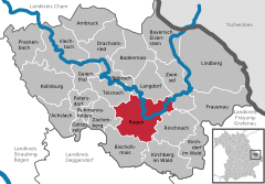 | |
 Regen  Regen | |
| Coordinates: 48°58′N 13°8′E / 48.967°N 13.133°E | |
| Country | Germany |
| State | Bavaria |
| Admin. region | Lower Bavaria |
| District | Regen |
| Subdivisions | 59 districts |
| Government | |
| • Mayor (2020–26) | Andreas Kroner[1] (SPD) |
| Area | |
| • Total | 65.15 km2 (25.15 sq mi) |
| Elevation | 530 m (1,740 ft) |
| Population (2022-12-31)[2] | |
| • Total | 11,005 |
| • Density | 170/km2 (440/sq mi) |
| Time zone | UTC+01:00 (CET) |
| • Summer (DST) | UTC+02:00 (CEST) |
| Postal codes | 94209 |
| Dialling codes | 09921 |
| Vehicle registration | REG |
| Website | www.regen.de |
Regen (Northern Bavarian: Reng) is a town in Bavaria, Germany, and the district town of the district of Regen.
Geography[edit]
Regen is situated on the great Regen River, located in the Bavarian Forest.
Divisions[edit]
Originally the town consisted of 4 districts: Bürgerholz, Grubhügel, Riedham and St. Johann.
After a governmental reform the villages of:
- Aden
- Augrub
- Bärndorf
- Bettmannsäge
- Dreieck
- Ebenhof
- Ecklend
- Edhof
- Eggenried
- Finkenried
- Frauenmühle
- Großseiboldsried
- Huberhof
- Kagerhof
- Kattersdorf
- Kerschlhöh
- Kleinseiboldsried
- Kreuzerhof
- Kühhof
- March
- Maschenberg
- Matzelsried
- Metten
- Neigerhöhe
- Neigermühle
- Neusohl
- Obermitterdorf
- Oberneumais
- Oleumhütte
- Pfistermühle
- Pometsau
- Poschetsried
- Reinhartsmais
- Richtplatz
- Rinchnachmündt
- Rohrbach
- Sallitz
- Schauerhof
- Schlossau
- Schochert
- Schollenried
- Schönhöh
- Schützenhof
- Schwaighof
- Schweinhütt
- Spitalhof
- Sumpering
- Tausendbach
- Thanhof
- Thurnhof
- Weißenstein
- Weißensteiner-Au
- Wickersdorf
- Wieshof and Windschnur
were added.
Population development[edit]
- 1828: 1196
- 1904: 2366
- 1974: 9029
- 2005: 12.553
- 2015: 10.855
International relations[edit]
Regen is twinned with:
Notable places[edit]
The "Niederbayrisches Landwirtschaftsmuseum" is a museum showing the history of agriculture and society in Lower Bavaria from the 18th and 19th century.
The "Fressendes Haus" is a former domicile of the poets Clara Nordström (1886–1962) and Siegfried von Vegesack (1888–1974), which was transformed in a museum in 1984 presenting different expositions of historical art and the archeological excavations at the castle ruin of Weißenstein.
Natural monuments[edit]
- The Pfahl is a 150-kilometre-long quartz ridge. In the vicinity of Weißenstein it reaches its highest point at 750 metres at the site of Weißenstein Castle.
Economy[edit]
Tourism figures largely in the local economy, with over 64,000 visitors accounting for 220,000 over-night stays last year.
Personalities[edit]
- Clara Nordström, Swedish writer (1886-1962)
References[edit]
- ^ Liste der ersten Bürgermeister/Oberbürgermeister in kreisangehörigen Gemeinden, Bayerisches Landesamt für Statistik, 15 July 2021.
- ^ Genesis Online-Datenbank des Bayerischen Landesamtes für Statistik Tabelle 12411-003r Fortschreibung des Bevölkerungsstandes: Gemeinden, Stichtag (Einwohnerzahlen auf Grundlage des Zensus 2011) (Hilfe dazu).
External links[edit]
- Official website
 (in German)
 - Pichelsteinerfest Regen (in German)
Towns and municipalities in Regen (district) | ||
|---|---|---|
 | ||
| International | |
|---|---|
| National | |
| Geographic | |