
The Whistlers (Alberta)
| The Whistlers | |
|---|---|
.jpg) The Whistlers seen from Jasper | |
| Highest point | |
| Elevation | 2,470 m (8,100 ft)[1] |
| Prominence | 160 m (520 ft)[1] |
| Parent peak | Indian Peak (2820 m)[1] |
| Listing | Mountains of Alberta |
| Coordinates | 52°49′37″N 118°07′58″W / 52.82694°N 118.13278°W[2] |
| Geography | |
 The Whistlers Location of The Whistlers in Alberta  The Whistlers The Whistlers (Canada) | |
| Location | Jasper National Park Alberta, Canada |
| Parent range | Trident Range Canadian Rockies[1] |
| Topo map | NTS 83D16 Jasper[2] |
| Climbing | |
| Easiest route | Tram, hiking |
The Whistlers is a 2,470-metre (8,100-foot) mountain summit located in Jasper National Park, in the Trident Range of the Canadian Rockies of Alberta, Canada. The municipality of Jasper is situated 7 kilometres to the northeast. The nearest higher neighbor is Indian Peak, 2.5 km (1.6 mi) to the southwest.[1] The highest and longest aerial tramway in Canada ascends to a lookout at 2,277 meters elevation, still 193 meters below the summit, but a hiking trail continues to the summit. Some of the mountains that can be seen (weather permitting) from the top include Mount Robson, Mount Bridgland, Monarch Mountain, Cairngorm, Pyramid Mountain, Hawk Mountain, Mount Colin, Grisette Mountain, Mount Tekarra, Mount Hardisty, Mount Kerkeslin, Marmot Mountain, Terminal Mountain, and Manx Peak.
History[edit]
The descriptive name The Whistlers was applied in 1916 by Édouard-Gaston Deville of the Geological Survey of Canada for the whistling inhabitants of the mountain, the hoary marmot.[3][4] The mountain's toponym was officially adopted in 1951 by the Geographical Names Board of Canada.[2]
Climate[edit]
Based on the Köppen climate classification, The Whistlers is located in a subarctic climate zone with cold, snowy winters, and mild summers.[5] Winter temperatures can drop below -20 °C with wind chill factors below -30 °C. Precipitation runoff from The Whistlers drains into tributaries of the Athabasca River.
See also[edit]
Gallery[edit]
Views from the top
-
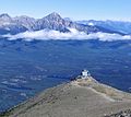 Summit view of the lookout and Pyramid Mountain
 -
 View of Terminal Mountain and Manx Peak
 -
 View of Jasper and the Colin Range
 -
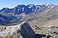
 View south L→R Mount Edith Cavell, Lectern Peak, Marmot Mountain, Chak Peak, Throne Mountain, Blackhorn Peak.
 -
 Walking to the top of The Whistlers
 -
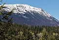 East aspect
 -
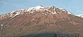 The Whistlers seen from Jasper


References[edit]
- ^ a b c d e "Whistlers Peak (The Whistlers)". Bivouac.com. Retrieved 2019-03-08.
- ^ a b c "The Whistlers". Geographical Names Data Base. Natural Resources Canada. Retrieved 2019-03-10.
- ^ "The Whistlers". cdnrockiesdatabases.ca. Retrieved 2021-03-22.
- ^ Place-names of Alberta. Ottawa: Geographic Board of Canada. 1928. p. 134.
- ^ Peel, M. C.; Finlayson, B. L. & McMahon, T. A. (2007). "Updated world map of the Köppen−Geiger climate classification". Hydrol. Earth Syst. Sci. 11 (5): 1633–1644. Bibcode:2007HESS...11.1633P. doi:10.5194/hess-11-1633-2007. ISSN 1027-5606. S2CID 9654551.
External links[edit]
- Parks Canada web site: Jasper National Park
- Webcam and weather: Jasper Skytram
- The Whistlers: weather forecast