
Uyo
Uyo | |
|---|---|
City | |
| Motto: Land of Promise | |
 Uyo | |
| Coordinates: 5°02′00″N 7°55′39″E / 5.03333°N 7.92750°E | |
| Country | |
| State | Akwa Ibom |
| Government | |
| • Type | State Capital |
| • Chairman | Dr. Uwemedimo Udo |
| Area | |
| • City | 362 km2 (140 sq mi) |
| Population (2006 census)[1] | |
| • City | 427,873 |
| • Density | 1,200/km2 (3,100/sq mi) |
| • Urban | 554,906 |
| GDP (PPP, 2015 int. Dollar) | |
| • Year | 2023 |
| • Total | $12.4 billion[2] |
| • Per capita | $9,300 |
| Time zone | UTC+1 (WAT) |
| Area code | 085 |
| Vehicle registration | UYY |
| Climate | Am |
| Website | http://akwaibomstate.gov.ng |
 | |
Uyo is one of the local government areas and the capital city of Akwa Ibom in South South Nigeria. Ibibio is the language spoken in Uyo.[3][4]
It became the capital on September 23, 1987 when Akwa Ibom was created from the former Cross River State.[5] According to the 2006 Nigerian Census, the population of Uyo (including Itu) is 427,873,[6] while the greater urban area, including Uruan, has a population of 554,906.[7]
Ibibio is the primary indigenous language.[8] The main campus of the University of Uyo is in Nwaniba, with satellites on Ikpa Road.[9]
Airport[edit]
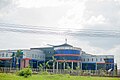
Victor Attah International Airport is located in the capital city of Akwa Ibom.[10]
Ibom Air is located in Uyo
Education[edit]
Transportation[edit]
Sports[edit]
Religion[edit]
Climate[edit]
With warm, cloudy wet seasons and hot, largely cloudy dry seasons, Uyo has a year-round oppressive environment with temperatures ranging from 69 °F to 87 °F.[11][12][13][14]
| Climate data for Uyo (1991–2020) | |||||||||||||
|---|---|---|---|---|---|---|---|---|---|---|---|---|---|
| Month | Jan | Feb | Mar | Apr | May | Jun | Jul | Aug | Sep | Oct | Nov | Dec | Year |
| Record high °C (°F) | 38.1 (100.6) |
39.5 (103.1) |
38.5 (101.3) |
36.7 (98.1) |
36 (97) |
34.7 (94.5) |
35.3 (95.5) |
33.6 (92.5) |
39 (102) |
38 (100) |
36 (97) |
36.3 (97.3) |
39.5 (103.1) |
| Mean daily maximum °C (°F) | 33.3 (91.9) |
34.6 (94.3) |
33.5 (92.3) |
32.7 (90.9) |
31.9 (89.4) |
30.4 (86.7) |
29.1 (84.4) |
28.8 (83.8) |
29.6 (85.3) |
30.6 (87.1) |
31.7 (89.1) |
32.6 (90.7) |
31.6 (88.9) |
| Daily mean °C (°F) | 27.7 (81.9) |
29.2 (84.6) |
28.8 (83.8) |
28.3 (82.9) |
27.8 (82.0) |
26.8 (80.2) |
26.0 (78.8) |
25.8 (78.4) |
26.3 (79.3) |
26.8 (80.2) |
27.5 (81.5) |
27.6 (81.7) |
27.4 (81.3) |
| Mean daily minimum °C (°F) | 22.2 (72.0) |
23.8 (74.8) |
24.2 (75.6) |
24.0 (75.2) |
23.8 (74.8) |
23.3 (73.9) |
22.9 (73.2) |
22.9 (73.2) |
23.0 (73.4) |
23.1 (73.6) |
23.3 (73.9) |
22.6 (72.7) |
23.3 (73.9) |
| Record low °C (°F) | 15 (59) |
18 (64) |
20 (68) |
20.5 (68.9) |
20 (68) |
19 (66) |
19.5 (67.1) |
19 (66) |
19 (66) |
20 (68) |
20 (68) |
15 (59) |
15.0 (59.0) |
| Average precipitation mm (inches) | 15.2 (0.60) |
47.1 (1.85) |
124.5 (4.90) |
193.6 (7.62) |
279.1 (10.99) |
303.8 (11.96) |
395.2 (15.56) |
327.6 (12.90) |
318.9 (12.56) |
292.2 (11.50) |
127.4 (5.02) |
11.2 (0.44) |
2,435.8 (95.90) |
| Average precipitation days (≥ 1.0 mm) | 1.4 | 2.9 | 8.7 | 11.5 | 14.7 | 16.5 | 20.3 | 20.0 | 19.1 | 16.2 | 8.5 | 1.1 | 140.8 |
| Average relative humidity (%) | 77.9 | 80.8 | 86.2 | 88.1 | 89.2 | 90.6 | 90.9 | 90.8 | 91.2 | 90.8 | 87.8 | 80.3 | 87.1 |
| Source: NOAA[15] | |||||||||||||
Wind[edit]
The average wind vector in Uyo, which is greatly influenced by terrain and other local characteristics, is discussed in this section. August is the windiest month, with an average wind speed of 6.4 miles per hour. The windier season lasts 4.4 months. The more tranquil period lasts 7.6 months, with December having the lowest average speed of 4.0 miles per hour.[11][12][13]
Gallery[edit]
-

-
-
-
-
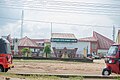
 University of Uyo


See also[edit]
References[edit]
- ^ Summing the 2 LGAs Uyo and Itu LGA's as per:
Federal Republic of Nigeria Official Gazette (15 May 2007). "Legal Notice on Publication of the Details of the Breakdown of the National and State Provisional Totals 2006 Census" (PDF). Archived from the original (PDF) on 31 January 2012. Retrieved 19 May 2007. - ^ "TelluBase—Nigeria Fact Sheet (Tellusant Public Service Series)" (PDF). Tellusant. Retrieved 2024-01-11.
- ^ "Uyo | Location, Facts, & Population". Encyclopedia Britannica. Retrieved 2021-09-12.
- ^ "Uyo | Location, Facts, & Population | Britannica". www.britannica.com. Retrieved 2022-11-14.
- ^ BusinessDay (2022-12-23). "Akwa Ibom at 35: Moving forward in business and leadership transformation". Businessday NG. Retrieved 2023-06-21.
{{cite web}}:|last=has generic name (help) - ^ Summing the 2 LGAs Uyo and Itu LGA's as per:
Federal Republic of Nigeria Official Gazette (15 May 2007). "Legal Notice on Publication of the Details of the Breakdown of the National and State Provisional Totals 2006 Census" (PDF). Retrieved 2007-05-19. - ^ Summing the 2 LGAs Uyo and Itu LGA's as per:
Federal Republic of Nigeria Official Gazette (15 May 2007). "Legal Notice on Publication of the Details of the Breakdown of the National and State Provisional Totals 2006 Census" (PDF). Retrieved 2007-05-19. - ^ "Ibibio | people". Encyclopedia Britannica. Retrieved 2021-09-10.
- ^ "LIST OF CONTRIBUTORS", Shallow Impurity Centers in Semiconductors, Elsevier, p. 304, 1987, retrieved 2024-01-30
- ^ "Obong Victor Attah International Airport Profile | CAPA". centreforaviation.com. Retrieved 2023-07-15.
- ^ a b "Uyo Climate, Weather By Month, Average Temperature (Nigeria) - Weather Spark". weatherspark.com. Retrieved 2023-08-27.
- ^ a b "Weather for Uyo, Akwa Ibom, Nigeria". www.timeanddate.com. Retrieved 2023-08-27.
- ^ a b "Uyo Weather". WorldWeatherOnline.com. Retrieved 2023-08-27.
- ^ "Weather today - Uyo, Nigeria". Weather Atlas. Retrieved 2023-08-27.
- ^ "World Meteorological Organization Climate Normals for 1991-2020 — Uyo". National Oceanic and Atmospheric Administration. Retrieved January 8, 2024.
State capital: Uyo | ||
| Local Government Areas |  | |
| International | |
|---|---|
| National | |