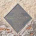
File:18 June 1815 – Victory at Waterloo – La Haye Sainte. Plaque to the K.G.L.jpg

Original file (1,600 × 1,600 pixels, file size: 2.38 MB, MIME type: image/jpeg)
| This is a file from the Wikimedia Commons. Information from its description page there is shown below. Commons is a freely licensed media file repository. You can help. |
Summary
| Description18 June 1815 – Victory at Waterloo – La Haye Sainte. Plaque to the K.G.L.jpg |
English: Plaque imbedded in 1847 in the eastern gable of the La Haye Sainte main building, overlooking the road N.5, replacing a previous marble tablet presumably affixed in 1818, along with the construction of the monument to the K.G.L. : ►(File:18 June 1815 – Victory at Waterloo – Hanoverian Monument, The South Face.jpg).
La ferme a été rebâtie et est, comme jadis, bornée au sud par un verger. Les champs voisins, où le carnage a été affreux, constituent en réalité une immense nécropole. Une seule fosse, pratiquée dans la vallon, vers l'est, a reçu les corps de 4,000 soldats et d'un grand nombre de chevaux.
Tarlier, Charles ; Wauters, Alphonse, Géographie et histoire des communes belges, vol. 1, Novembre 1869, 78.
|
| Date | |
| Source | Own work |
| Author | Alta Falisa |
| Camera location | 50° 40′ 41.66″ N, 4° 24′ 44.24″ E | View this and other nearby images on: OpenStreetMap |
|---|
Licensing
- You are free:
- to share – to copy, distribute and transmit the work
- to remix – to adapt the work
- Under the following conditions:
- attribution – You must give appropriate credit, provide a link to the license, and indicate if changes were made. You may do so in any reasonable manner, but not in any way that suggests the licensor endorses you or your use.
- share alike – If you remix, transform, or build upon the material, you must distribute your contributions under the same or compatible license as the original.
Captions
Items portrayed in this file
depicts
some value
10 April 2016
50°40'41.66"N, 4°24'44.24"E
0.00076923076923076923 second
18 millimetre
400
image/jpeg
432d39be57f5ed9d965eb73308410ddc3db86aa3
2,497,422 byte
1,600 pixel
1,600 pixel
File history
Click on a date/time to view the file as it appeared at that time.
| Date/Time | Thumbnail | Dimensions | User | Comment | |
|---|---|---|---|---|---|
| current | 16:30, 17 February 2021 |  | 1,600 × 1,600 (2.38 MB) | Alta Falisa | Uploaded own work with UploadWizard |
File usage
Metadata
This file contains additional information, probably added from the digital camera or scanner used to create or digitize it.
If the file has been modified from its original state, some details may not fully reflect the modified file.
| Camera manufacturer | FUJIFILM |
|---|---|
| Camera model | FinePix S100FS |
| Exposure time | 1/1,300 sec (0.00076923076923077) |
| F-number | f/8 |
| ISO speed rating | 400 |
| Date and time of data generation | 08:22, 10 April 2016 |
| Lens focal length | 18 mm |
| Horizontal resolution | 72 dpi |
| Vertical resolution | 72 dpi |
| Software used | PhotoScape |
| File change date and time | 08:22, 10 April 2016 |
| Y and C positioning | Co-sited |
| Exposure Program | Normal program |
| Exif version | 2.2 |
| Date and time of digitizing | 08:22, 10 April 2016 |
| Meaning of each component |
|
| Image compression mode | 2 |
| Shutter speed | 10.34 |
| APEX aperture | 6 |
| APEX brightness | 9.75 |
| Exposure bias | 0 |
| Maximum land aperture | 3 APEX (f/2.83) |
| Metering mode | Pattern |
| Light source | Unknown |
| Flash | Flash did not fire, compulsory flash suppression |
| Supported Flashpix version | 1 |
| Color space | sRGB |
| Focal plane X resolution | 4,418 |
| Focal plane Y resolution | 4,418 |
| Focal plane resolution unit | 3 |
| Sensing method | One-chip color area sensor |
| File source | Digital still camera |
| Scene type | A directly photographed image |
| Custom image processing | Normal process |
| Exposure mode | Auto exposure |
| White balance | Auto white balance |
| Scene capture type | Standard |
| Sharpness | Normal |
| Subject distance range | Unknown |
