
File:Blue Creek Canyon (Gunnison County, Colorado).JPG

Size of this preview: 800 × 552 pixels. Other resolutions: 320 × 221 pixels | 640 × 441 pixels | 1,024 × 706 pixels | 1,280 × 883 pixels | 2,560 × 1,765 pixels | 5,009 × 3,454 pixels.
Original file (5,009 × 3,454 pixels, file size: 7.89 MB, MIME type: image/jpeg)
| This is a file from the Wikimedia Commons. Information from its description page there is shown below. Commons is a freely licensed media file repository. You can help. |
.JPG)
Summary
| Description |
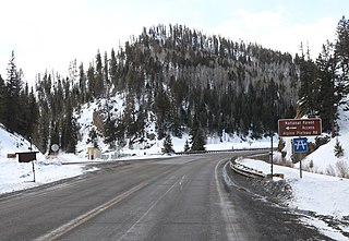
English: U.S. Route 50 in Blue Creek Canyon, in Gunnison County, Colorado. The picture shows the highway's intersection with Alpine Plateau Road. Blue Creek is on the right side of the bridge. The confluence of Little Blue Creek and Big Blue Creek, where Blue Creek begins, is on the left side of the bridge, behind the mailboxes. |
| Date | |
| Source | Own work |
| Author | Jeffrey Beall |
| Camera location | | View this and other nearby images on: OpenStreetMap |
|---|
.JPG¶ms=038.405433_N_-107.407794_E_globe:Earth_type:camera__&language=en)
Licensing
I, the copyright holder of this work, hereby publish it under the following license:
This file is licensed under the Creative Commons Attribution 4.0 International license.
- You are free:
- to share – to copy, distribute and transmit the work
- to remix – to adapt the work
- Under the following conditions:
- attribution – You must give appropriate credit, provide a link to the license, and indicate if changes were made. You may do so in any reasonable manner, but not in any way that suggests the licensor endorses you or your use.
File history
Click on a date/time to view the file as it appeared at that time.
| Date/Time | Thumbnail | Dimensions | User | Comment | |
|---|---|---|---|---|---|
| current | 19:33, 12 March 2020 | | 5,009 × 3,454 (7.89 MB) | Jeffrey Beall | {{Information |description ={{en|1={{W|U.S. Route 50}} in Blue Creek Canyon, in {{W|Gunnison County, Colorado}}. The picture shows the highway's intersection with Alpine Plateau Road. Blue Creek is on the right side of the bridge. The confluence of Little Blue Creek and Big Blue Creek, where Blue Creek begins, is on the left side of the bridge, behind the mailboxes. }} |date =2020-02-25 |source ={{own}} |author =User:Jeffrey Beall }} {{Location|38|24|19.56|N|107|... |
File usage
The following pages on the English Wikipedia use this file (pages on other projects are not listed):
.JPG)