
File:CHADOPyF-mapa.jpg
Size of this preview: 432 × 599 pixels. Other resolutions: 173 × 240 pixels | 460 × 638 pixels.
Original file (460 × 638 pixels, file size: 65 KB, MIME type: image/jpeg)
| This is a file from the Wikimedia Commons. Information from its description page there is shown below. Commons is a freely licensed media file repository. You can help. |
Summary
| Description |
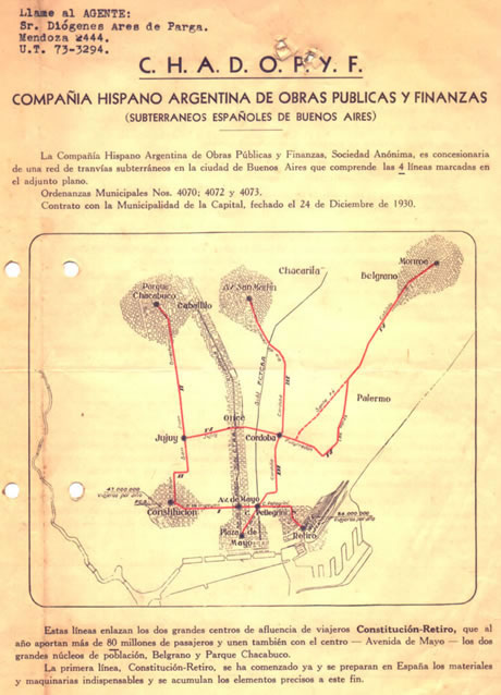
English: Map of the projected lines for the Buenos Aires Underground, done by "Compañía Hispano Argentina de Obras Públicas y Finanzas" - CHADOPYF. |
| Date | |
| Source | here |
| Author |
Licensing
The copyright of this anonymous work belonging to an institution, corporation or legal entity, registered in Argentina, has expired, and it has entered the public domain. At least 50 years have passed after the anonymous work was first published (Law 11.723, articles 8 and 28 and its modifications).
Nevertheless, its source must be acknowledged. |
 | |
This work is in the public domain in the United States because it meets three requirements:
For background information, see the explanations on Non-U.S. copyrights.
Note: This tag should not be used for sound recordings. |
File history
Click on a date/time to view the file as it appeared at that time.
| Date/Time | Thumbnail | Dimensions | User | Comment | |
|---|---|---|---|---|---|
| current | 04:09, 30 April 2014 | | 460 × 638 (65 KB) | JonySniuk | User created page with UploadWizard |
File usage
The following pages on the English Wikipedia use this file (pages on other projects are not listed):
Global file usage
The following other wikis use this file:
- Usage on es.wikipedia.org
- Usage on www.wikidata.org