
File:Croxton Park, near Croxton Kerrial - geograph.org.uk - 67369.jpg
No higher resolution available.
Croxton_Park,_near_Croxton_Kerrial_-_geograph.org.uk_-_67369.jpg (640 × 480 pixels, file size: 150 KB, MIME type: image/jpeg)
| This is a file from the Wikimedia Commons. Information from its description page there is shown below. Commons is a freely licensed media file repository. You can help. |
Summary
| Description |
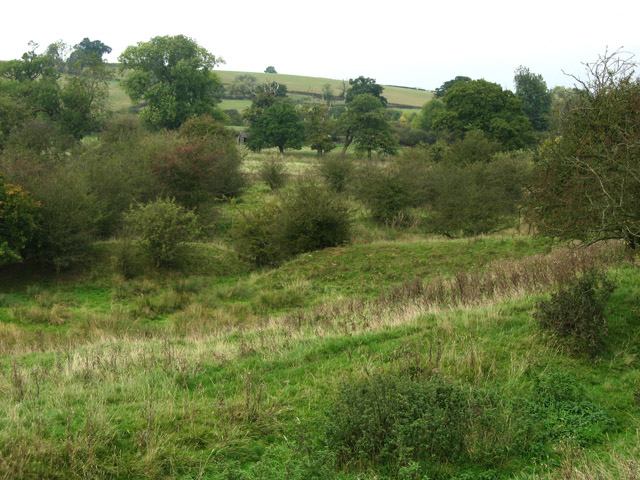
English: Croxton Park, near Croxton Kerrial. Very rough scrubby land falling away to the stream which is one of the feeders into the lakes at Belvoir Castle. The main A607 runs just below the hill in the background. Croxton Park is of medieval origin. It is probably the best remaining example of ancient parkland in Leicestershire with largely unimproved rough pasture around the ancient trees. The lichen flora is amongst the richest in the East Midlands and the diversity of breeding birds is outstanding. The site lies partly on the Northampton sands but the valleys cut into Upper Lias Clay. On the sands a neutral to acid grassland has developed. Marshy areas within are dominated by rushes. Meadow grasses and cowslips occur in areas which are influenced by the underlying Lincolnshire limestone. Ancient pedunculate oaks and hawthorns occur sparingly in the grazed areas and amongst 200 year old oak plantations. The old oaks and ash trees in the sheltered valleys support many uncommon lichens. The old limestone walls also support a good selection of lichens including the only County record of Lecania baeomma. The old hollow trees, scrub filled valleys, ponds and large expanses of grassland provide excellent breeding bird habitats. Species include mallard, snipe, woodcock, curlew, woodpeckers, redstart, tree pipit, yellow wagtail and corn bunting. |
| Date | |
| Source | From geograph.org.uk |
| Author | Kate Jewell |
| Attribution (required by the license) | Kate Jewell / Croxton Park, near Croxton Kerrial / |
| Camera location | | View this and other nearby images on: OpenStreetMap |
|---|
_heading:0.00&language=en)
| Object location | | View this and other nearby images on: OpenStreetMap |
|---|
_heading:0.00&language=en)
Licensing

|
This image was taken from the Geograph project collection. See this photograph's page on the Geograph website for the photographer's contact details. The copyright on this image is owned by Kate Jewell and is licensed for reuse under the Creative Commons Attribution-ShareAlike 2.0 license.
|
This file is licensed under the Creative Commons Attribution-Share Alike 2.0 Generic license.
Attribution: Kate Jewell
- You are free:
- to share – to copy, distribute and transmit the work
- to remix – to adapt the work
- Under the following conditions:
- attribution – You must give appropriate credit, provide a link to the license, and indicate if changes were made. You may do so in any reasonable manner, but not in any way that suggests the licensor endorses you or your use.
- share alike – If you remix, transform, or build upon the material, you must distribute your contributions under the same or compatible license as the original.
File history
Click on a date/time to view the file as it appeared at that time.
| Date/Time | Thumbnail | Dimensions | User | Comment | |
|---|---|---|---|---|---|
| current | 14:26, 30 January 2010 | | 640 × 480 (150 KB) | GeographBot | == {{int:filedesc}} == {{Information |description={{en|1=Croxton Park, near Croxton Kerrial. Very rough scrubby land falling away to the stream which is one of the feeders into the lakes at Belvoir Castle. The main A607 runs just below the hill in the bac |
File usage
The following pages on the English Wikipedia use this file (pages on other projects are not listed):