
File:Henderson Powell Valley Grant.jpg

Size of this preview: 601 × 599 pixels. Other resolutions: 241 × 240 pixels | 481 × 480 pixels | 770 × 768 pixels | 1,027 × 1,024 pixels | 1,596 × 1,592 pixels.
Original file (1,596 × 1,592 pixels, file size: 838 KB, MIME type: image/jpeg)
| This is a file from the Wikimedia Commons. Information from its description page there is shown below. Commons is a freely licensed media file repository. You can help. |
Summary
| Description |
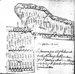
English: The drawing is the map drawn by the surveyors of the property granted to the Henderson & Co. The property lies along the Powell River between the Cumberland Mountain and the Powell Mountain. The westerly line is the line of the Great Grant that extends to form the Path Grant and the boundary on the south is contiguous with the Path Grant. A second tract is on the Clinch River further to the west in Tennessee. Taken together the total is said to be 200,000 acres.
The tract is noted in Yellow as #2 on the Great Grant Map above. |
| Date | |
| Source | North Carolina Archives |
| Author | Surveyed by: J. Maybury and J. Donelson |
Licensing
|
This work is in the public domain in its country of origin and other countries and areas where the copyright term is the author's life plus 70 years or fewer. This work is in the public domain in the United States because it was published (or registered with the U.S. Copyright Office) before January 1, 1929. | |
| This file has been identified as being free of known restrictions under copyright law, including all related and neighboring rights. | |
File history
Click on a date/time to view the file as it appeared at that time.
| Date/Time | Thumbnail | Dimensions | User | Comment | |
|---|---|---|---|---|---|
| current | 20:43, 17 February 2015 | | 1,596 × 1,592 (838 KB) | Bertmbc | User created page with UploadWizard |
File usage
The following pages on the English Wikipedia use this file (pages on other projects are not listed):