
File:Izilda 25 March 2009 at 0715 UTC.jpg

Size of this preview: 466 × 599 pixels. Other resolutions: 187 × 240 pixels | 373 × 480 pixels | 597 × 768 pixels | 796 × 1,024 pixels | 1,593 × 2,048 pixels | 5,600 × 7,200 pixels.
Original file (5,600 × 7,200 pixels, file size: 8.73 MB, MIME type: image/jpeg)
| This is a file from the Wikimedia Commons. Information from its description page there is shown below. Commons is a freely licensed media file repository. You can help. |
Summary
| Description |
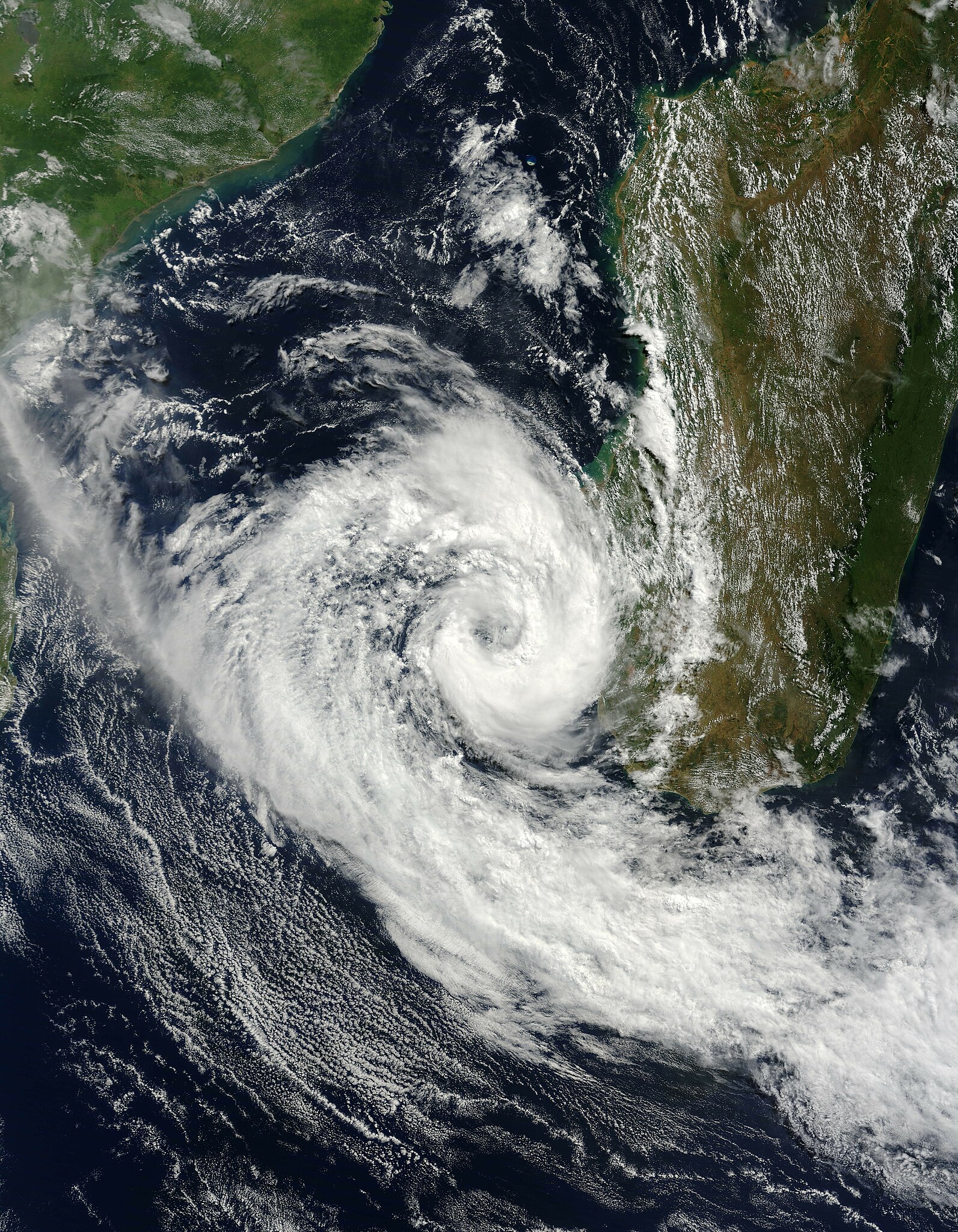
English: Cyclone Izilda was near its peak strength when the Moderate Resolution Imaging Spectroradiometer (MODIS) on NASA’s Terra satellite captured this image on March 25, 2009. As far as cyclones go, the comma-shaped storm was weak, with winds estimated at 65 kilometers per hour (40 miles per hour or 35 knots). The Joint Typhoon Warning Center forecast that the storm would weaken as it moved south through the Mozambique Channel. It was not forecast to go ashore.
Most of the clouds in this photo-like image are concentrated in Cyclone Izilda, leaving a relatively clear view of southern Madagascar. A line of dark green mountains runs up the eastern side of the island. To the east, the land is lush and green. Inland, to the west of the mountains, the land is drier and brown. |
| Date | |
| Source | http://earthobservatory.nasa.gov/NaturalHazards/view.php?id=37645 |
| Author | NASA |
Licensing
| This file is in the public domain in the United States because it was solely created by NASA. NASA copyright policy states that "NASA material is not protected by copyright unless noted". (See Template:PD-USGov, NASA copyright policy page or JPL Image Use Policy.) | ||
 |
Warnings:
|
File history
Click on a date/time to view the file as it appeared at that time.
| Date/Time | Thumbnail | Dimensions | User | Comment | |
|---|---|---|---|---|---|
| current | 23:42, 26 March 2009 | | 5,600 × 7,200 (8.73 MB) | Potapych | That version is off center and clips off the storm |
| 22:08, 26 March 2009 |  | 3,843 × 4,057 (3.97 MB) | HurricaneSpin | Cropped | |
| 13:24, 26 March 2009 |  | 5,600 × 7,200 (8.73 MB) | Potapych | NASA images never work... | |
| 13:20, 26 March 2009 |  | 5,600 × 7,200 (5.14 MB) | Potapych | {{Information |Description={{en|1=Cyclone Izilda was near its peak strength when the Moderate Resolution Imaging Spectroradiometer (MODIS) on NASA’s Terra satellite captured this image on March 25, 2009. As far as cyclones go, the comma-shaped storm was |
File usage
The following pages on the English Wikipedia use this file (pages on other projects are not listed):
Global file usage
The following other wikis use this file:
- Usage on de.wikipedia.org
- Usage on es.wikipedia.org
- Usage on pt.wikipedia.org
- Usage on zh.wikipedia.org