
File:Old Bridge Marker on Quay Road, West Looe (geograph 6945617 by T Jenkinson).jpg

Size of this preview: 800 × 600 pixels. Other resolutions: 320 × 240 pixels | 640 × 480 pixels | 1,024 × 768 pixels | 1,280 × 960 pixels | 2,560 × 1,920 pixels | 3,648 × 2,736 pixels.
Original file (3,648 × 2,736 pixels, file size: 1.52 MB, MIME type: image/jpeg)
| This is a file from the Wikimedia Commons. Information from its description page there is shown below. Commons is a freely licensed media file repository. You can help. |
.jpg)
Summary
| Description |
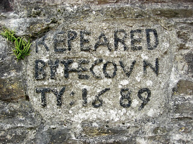
English: Bridge Marker on Quay Road, West Looe, in the east facing retaining wall of a walkway below the Old Bridge House. Looe parish. Near the west end of old Looe Bridge opened 1436 and pulled down in 1853. There is a similar stone in East Looe in the east facing wall of a car park opposite the Co-op in Fore. |
| Date | |
| Source | https://www.geograph.org.uk/photo/6945617 |
| Author | T Jenkinson |
| Attribution (required by the license) | T Jenkinson / Old Bridge Marker on Quay Road, West Looe / |
| Camera location | | View this and other nearby images on: OpenStreetMap |
|---|
.jpg¶ms=050.355473_N_-004.456603_E_globe:Earth_type:camera_source:geograph-osgb36(SX2534553504)_heading:247.00&language=en)
| Object location | | View this and other nearby images on: OpenStreetMap |
|---|
.jpg¶ms=050.355470_N_-004.456600_E_globe:Earth_class:object_type:object_source:geograph-osgb36(SX2534553504)_heading:247.00&language=en)
Licensing

|
This image was taken from the Geograph project collection. See this photograph's page on the Geograph website for the photographer's contact details. The copyright on this image is owned by T Jenkinson and is licensed for reuse under the Creative Commons Attribution-ShareAlike 2.0 license.
|
This file is licensed under the Creative Commons Attribution-Share Alike 2.0 Generic license.
Attribution: T Jenkinson
- You are free:
- to share – to copy, distribute and transmit the work
- to remix – to adapt the work
- Under the following conditions:
- attribution – You must give appropriate credit, provide a link to the license, and indicate if changes were made. You may do so in any reasonable manner, but not in any way that suggests the licensor endorses you or your use.
- share alike – If you remix, transform, or build upon the material, you must distribute your contributions under the same or compatible license as the original.
File history
Click on a date/time to view the file as it appeared at that time.
| Date/Time | Thumbnail | Dimensions | User | Comment | |
|---|---|---|---|---|---|
| current | 21:33, 10 January 2022 | | 3,648 × 2,736 (1.52 MB) | MIDI | Uploaded a work by T Jenkinson from https://www.geograph.org.uk/photo/6945617 with UploadWizard |
File usage
The following pages on the English Wikipedia use this file (pages on other projects are not listed):
Global file usage
The following other wikis use this file:
- Usage on th.wikipedia.org
.jpg)