
File:Ozark Trail Jan2009 relief map v3.jpg
Size of this preview: 800 × 552 pixels. Other resolutions: 320 × 221 pixels | 640 × 441 pixels | 1,024 × 706 pixels | 1,280 × 883 pixels | 2,217 × 1,529 pixels.
Original file (2,217 × 1,529 pixels, file size: 1.08 MB, MIME type: image/jpeg)
| This is a file from the Wikimedia Commons. Information from its description page there is shown below. Commons is a freely licensed media file repository. You can help. |
Summary
| Description | |
| Date | |
| Source | Own work |
| Author | Kbh3rd |
| Other versions | File:Ozark_Trail_completed_sections_w_relief_v1.jpg File:Ozark Trail completed sections w relief v3.jpg |
Georeference
| NAD83 GRS80 | ||
|---|---|---|
| Location | West Longitude | North Latitude |
| Upper-left | 92°49'50.638" | 38°6'52.107" |
| Lower-left | 92°50'3.401" | 36°31'0.504" |
| Upper-right | 89°54'3.856" | 38°4'25.375" |
| Lower-right | 89°57'57.07" | 36°28'41.964" |
| Center | 91°22'57.4" | 37°18'17.133" |
| UTM zone 15N NAD83 GRS80 (EPSG:26915) | ||
|---|---|---|
| Location | Easting | Northing |
| Upper-left | 514838.082 | 4218529.828 |
| Lower-left | 514838.082 | 4041285.103 |
| Upper-right | 771837.136 | 4218529.828 |
| Lower-right | 771837.136 | 4041285.103 |
| Center | 643337.609 | 4129907.465 |
World file for UTM zone 15N (EPSG:26915):
115.9219911372706
0
0
-115.9219911372706
514896.04250883596
4218471.8665569723
Licensing
I, the copyright holder of this work, hereby publish it under the following licenses:
This file is licensed under the Creative Commons Attribution-Share Alike 3.0 Unported license.
- You are free:
- to share – to copy, distribute and transmit the work
- to remix – to adapt the work
- Under the following conditions:
- attribution – You must give appropriate credit, provide a link to the license, and indicate if changes were made. You may do so in any reasonable manner, but not in any way that suggests the licensor endorses you or your use.
- share alike – If you remix, transform, or build upon the material, you must distribute your contributions under the same or compatible license as the original.

|
Permission is granted to copy, distribute and/or modify this document under the terms of the GNU Free Documentation License, Version 1.2 or any later version published by the Free Software Foundation; with no Invariant Sections, no Front-Cover Texts, and no Back-Cover Texts. A copy of the license is included in the section entitled GNU Free Documentation License. |
You may select the license of your choice.
File history
Click on a date/time to view the file as it appeared at that time.
| Date/Time | Thumbnail | Dimensions | User | Comment | |
|---|---|---|---|---|---|
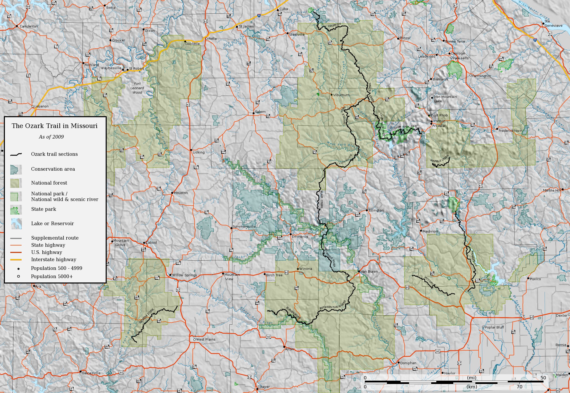
| current | 06:50, 20 January 2011 | | 2,217 × 1,529 (1.08 MB) | Kbh3rd | {{Information |Description={{en|1=Relief map of the Ozark Trail in Missouri as of January 2009.}} |Source={{own}} |Author=Kbh3rd |Date=2010-01-20 |Permission= |other_versions=[[:File:Ozar |
File usage
The following pages on the English Wikipedia use this file (pages on other projects are not listed):