
File:Satellitenbild Niederrheinische Bucht.png
Size of this preview: 717 × 600 pixels. Other resolutions: 287 × 240 pixels | 574 × 480 pixels | 918 × 768 pixels | 1,225 × 1,024 pixels | 1,625 × 1,359 pixels.
Original file (1,625 × 1,359 pixels, file size: 3.71 MB, MIME type: image/png)
| This is a file from the Wikimedia Commons. Information from its description page there is shown below. Commons is a freely licensed media file repository. You can help. |
| Description |
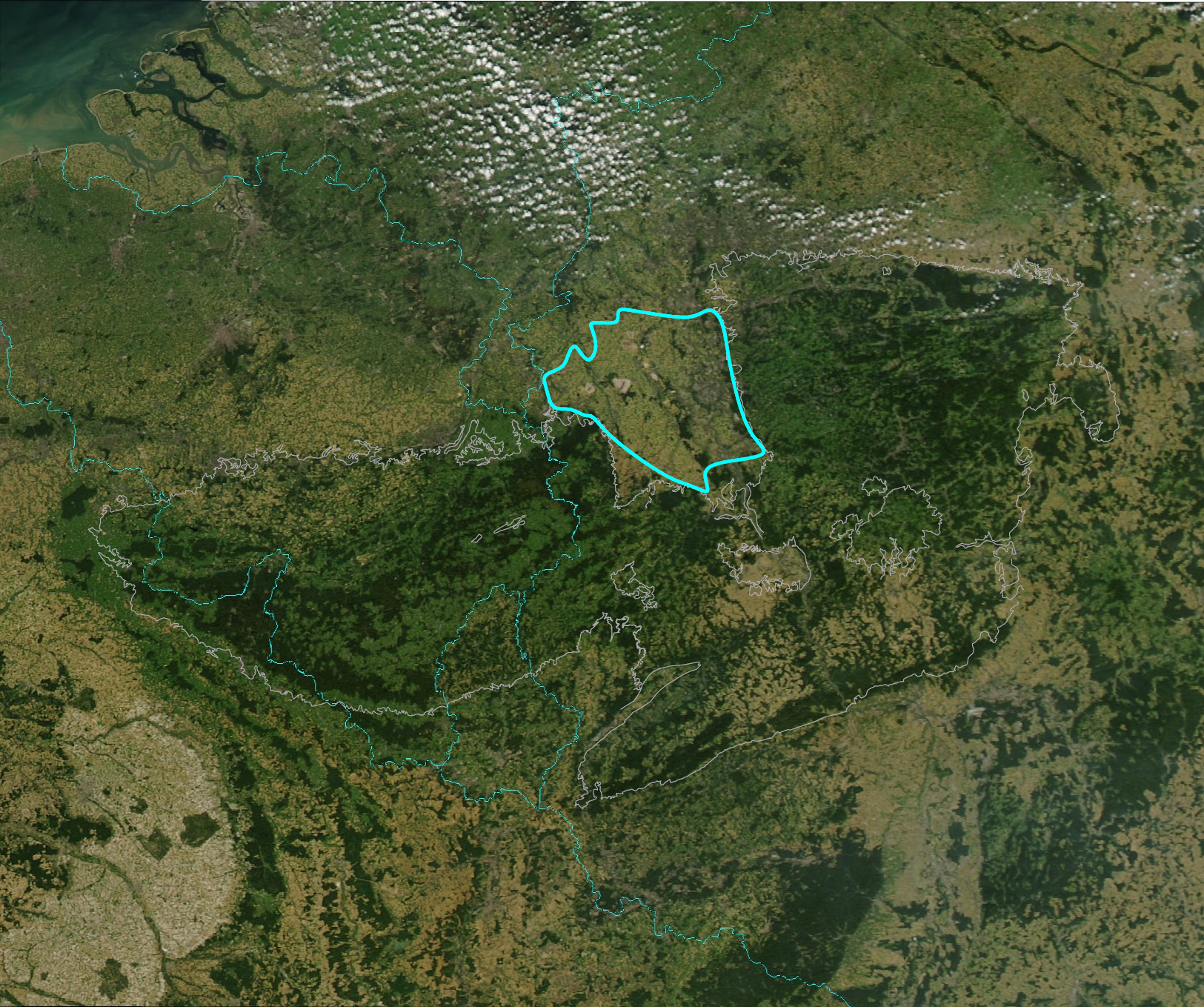
English: Outline of the Niederrheinische Bucht (fat line) on satellite image of Rheinisches Schiefergebirge (grey outline). Boundaries of Germany (right), the Netherlands (top), Belgium (upper left), France (lower left) and Luxemburg (lower center) for orientation (cyan).
Deutsch: Die Niederrheinische Bucht (fette Linie) auf einem Satellitenbild des Rheinischen Schiefergebirges (grauer Umriss). Die Grenzen von Deutschland (rechts), der Niederlande (links oben), Belgiens (obere Bildhälfte links), Frankreichs (untere Bildhälfte links) und Luxemburgs (untere Bildmitte) zur Orientierung (cyan). |
| Date | |
| Source | Image:RSG-NASA-250.jpg, Detail of Image:Europe-NW-A2002256.1250.250m.jpg. Niederrheinische Bucht: Schmitt, Eckart et al. (1975): Harms Handbuch der Geographie - Deutschland. 26. Auflage, Paul List Verlag, München, 432 S. ISBN 3-471-18803-7 |
| Author | drawn by Jo Weber on PD-image Image:RSG-NASA-250.jpg |
| Permission (Reusing this file) |
Additional PD-user for the outline drawing. Original satellite picture is PD-USGov-NASA. See below. |
| Other versions | Image:RSG-NASA-250 Ausschnitt mit Umriss.jpg, Image:RSG-NASA-250.jpg |
| This file is in the public domain in the United States because it was solely created by NASA. NASA copyright policy states that "NASA material is not protected by copyright unless noted". (See Template:PD-USGov, NASA copyright policy page or JPL Image Use Policy.) | ||
 |
Warnings:
|
| |
This work has been released into the public domain by its author, Jo weber, at the English Wikipedia project. This applies worldwide. In case this is not legally possible: |
File history
Click on a date/time to view the file as it appeared at that time.
| Date/Time | Thumbnail | Dimensions | User | Comment | |
|---|---|---|---|---|---|
| current | 13:01, 2 March 2008 | | 1,625 × 1,359 (3.71 MB) | Jo Weber | {{Information |Description = Outline of the ''Niederrheinische Bucht''(fat line) on satellite image of Rheinisches Schiefergebirge (grey outline). Boundaries of Germany (right), the Netherlands (top), Belgium (upper lef |
File usage
The following pages on the English Wikipedia use this file (pages on other projects are not listed):
Global file usage
The following other wikis use this file:
- Usage on de.wikipedia.org
- Usage on nl.wikipedia.org