
File:Stuttgart, Royal Air Force Bomber Command, 1942-1945. CL3437.jpg
Original file (3,019 × 2,480 pixels, file size: 2.52 MB, MIME type: image/jpeg)
| This is a file from the Wikimedia Commons. Information from its description page there is shown below. Commons is a freely licensed media file repository. You can help. |
Summary
| Artist |
Royal Air Force official photographer, Clark N S (Flt Lt) and Broom R R (Fg Off) |
|||
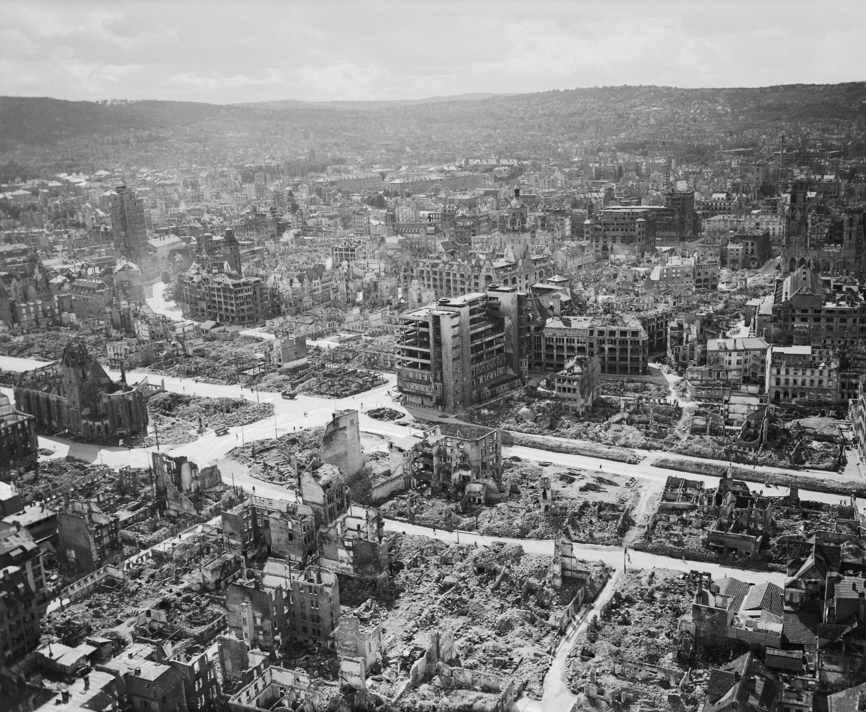
| Description |
English: Royal Air Force Bomber Command, 1942-1945.
Low-level aerial photograph of the devastated city centre of Stuttgart from the east, ca. 1945.
Deutsch: Luftbild des zerstörten Stuttgarter Zentrums, aus niedriger Höhe aufgenommen wohl nach Kriegsende 1945 etwa oberhalb der Kreuzung Charlottenstraße/Olgastraße, Blick westwärts. Hinweise zu den Bauwerken: Links die Leonhardskirche, weiter hinten links der Tagblatt-Turm. In der Mitte das Kaufhaus Breuninger, darüber das zu Anfang des 20. Jahrhunderts errichtete Gebäude des Rathauses, weiter hinten der Rotebühlbau, die ehemalige Rotebühlkaserne. Am rechten Rand die Stiftskirche, davor die Markthalle. |
|||
| Date | circa 1945 | |||
| Source/Photographer |
http://media.iwm.org.uk/iwm/mediaLib//8/media-8489/large.jpg
|
|||
| Permission (Reusing this file) |
This image was created and released by the Imperial War Museum on the IWM Non Commercial Licence. Photographs taken, or artworks created, by a member of the forces during their active service duties are covered by Crown Copyright provisions. Faithful reproductions may be reused under that licence, which is considered expired 50 years after their creation. | |||
| Part of | Air Ministry Second World War Official Collection | |||
| Subjects |
|
|||
| Category | photographs |

| Camera location | | View this and other nearby images on: OpenStreetMap |
|---|
.jpg)
Licensing
This image is in the public domain because it is a mere mechanical scan or photocopy of a public domain original, or – from the available evidence – is so similar to such a scan or photocopy that no copyright protection can be expected to arise. The original itself is in the public domain for the following reason:
This tag is designed for use where there may be a need to assert that any enhancements (eg brightness, contrast, colour-matching, sharpening) are in themselves insufficiently creative to generate a new copyright. It can be used where it is unknown whether any enhancements have been made, as well as when the enhancements are clear but insufficient. For known raw unenhanced scans you can use an appropriate {{PD-old}} tag instead. For usage, see Commons:When to use the PD-scan tag.  |

| Annotations | This image is annotated: View the annotations at Commons |
File history
Click on a date/time to view the file as it appeared at that time.
| Date/Time | Thumbnail | Dimensions | User | Comment | |
|---|---|---|---|---|---|
| current | 13:09, 4 October 2017 | | 3,019 × 2,480 (2.52 MB) | Ducksoup | Resolution 800×666, replace with 3,019×2,480 |
| 08:52, 28 January 2014 |  | 800 × 666 (128 KB) | Fæ | {{User:{{subst:User:Fae/Fae}}/IWM |description = {{en|''Royal Air Force Bomber Command, 1942-1945.''<br/> Low-level aerial photograph of the devastated city centre of Stuttgart from the south-west, after 53 major raids, most of them by Bomber Command,... |
File usage
Global file usage
The following other wikis use this file:
- Usage on cs.wikipedia.org
- Usage on de.wikipedia.org
- Usage on es.wikipedia.org
- Usage on it.wikipedia.org
- Usage on ja.wikipedia.org
- Usage on ru.wikipedia.org