
File:Winnemucca airport diagram.JPG
No higher resolution available.
Winnemucca_airport_diagram.JPG (217 × 378 pixels, file size: 20 KB, MIME type: image/jpeg)
| This is a file from the Wikimedia Commons. Information from its description page there is shown below. Commons is a freely licensed media file repository. You can help. |
Summary
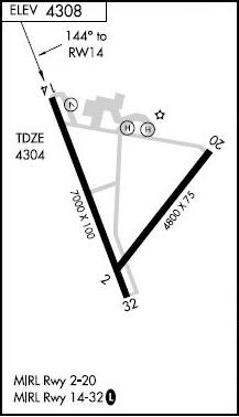
| Description | The diagram for w:Winnemucca Municipal Airport. |
| Date | (UTC) |
| Source | http://flightaware.com/resources/airport/WMC/IAP/RNAV+(GPS)+RWY+14/pdf |
| Author | FAA |
Licensing
This image or file is a work of a Federal Aviation Administration employee, taken or made as part of that person's official duties. As a work of the U.S. federal government, the image is in the public domain in the United States.
|
 |
Original upload log
The original description page was here. All following user names refer to en.wikipedia.
| Date/Time | Dimensions | User | Comment |
|---|---|---|---|
| 2010-05-02 01:10:34 | 217× 378× | Sumsum2010 | {{Information |Description = The diagram for [[Winnemucca Municiple airport]]. |Source = http://flightaware.com/resources/airport/WMC/IAP/RNAV+(GPS)+RWY+14/pdf |Date = ~~~~~ |Author = FAA |Permission = |other_versio |
File history
Click on a date/time to view the file as it appeared at that time.
| Date/Time | Thumbnail | Dimensions | User | Comment | |
|---|---|---|---|---|---|
| current | 20:09, 5 November 2016 | | 217 × 378 (20 KB) | FastilyClone | Transferred from en.wikipedia (MTC!) |
File usage
The following pages on the English Wikipedia use this file (pages on other projects are not listed):
Global file usage
The following other wikis use this file:
- Usage on tg.wikipedia.org