File:World trade map.PNG
Page contents not supported in other languages.
This is a file from the Wikimedia Commons
From Wikipedia, the free encyclopedia

Original file(1,357 × 628 pixels, file size: 41 KB, MIME type: image/png)

Summary

This economic map image could be re-created using vector graphics as an SVG file. This has several advantages; see Commons:Media for cleanup for more information. If an SVG form of this image is available, please upload it and afterwards replace this template with {{vector version available|new image name}}.


It is recommended to name the SVG file “World trade map.svg”—then the template Vector version available (or Vva) does not need the new image name parameter.
Description
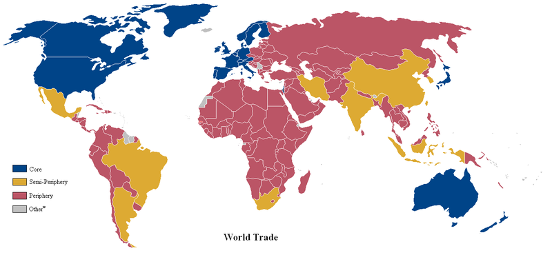
English: A world map of countries by trading status, late 20th century, using the world system differentiation into core countries, semi-periphery countries and periphery countries. Based on a list in Christopher Chase-Dunn, Yukio Kawano and Benjamin Brewer, Trade Globalization since 1795, American Sociological Review, 2000 February, Vol. 65 article, Appendix with the country list
*Some countries with a population of less than one million were excluded from the analysis.
Date (UTC)
Source Based on File:Anglosphere_map.png.
Author Lou Coban

Licensing

Public domain This work has been released into the public domain by its author, User:Naboc1. This applies worldwide.
In some countries this may not be legally possible; if so:
User:Naboc1 grants anyone the right to use this work for any purpose, without any conditions, unless such conditions are required by law.

Original upload log

Transferred from en.wikipedia to Commons by Piotrus using CommonsHelper.

The original description page was here. All following user names refer to en.wikipedia.
  • 2010-08-09 23:12 Altes 1357×628× (49371 bytes) fixed Brazil & Argentine
  • 2010-06-11 01:32 Naboc1 1357×628× (49325 bytes) Included a new "other" category to denote countries with a population less than one million.
  • 2010-06-10 18:09 Naboc1 1357×628× (48916 bytes) Updated Greenland as a core country since it is a part of Denmark
  • 2010-06-10 05:40 Naboc1 1357×628× (48911 bytes) Updated some coutries that were incorrectly indicated as the wrong status.
  • 2010-06-07 06:23 Naboc1 1357×628× (48895 bytes) {{Information |Description = A World map of countries by trading status |Source = |Date = ~~~~~ |Author = Lou Coban |Permission = |other_versions = }}

Captions

Add a one-line explanation of what this file represents

Items portrayed in this file

depicts

7 June 2010

File history

Click on a date/time to view the file as it appeared at that time.

Date/TimeThumbnailDimensionsUserComment
current00:20, 6 June 2022Thumbnail for version as of 00:20, 6 June 20221,357 × 628 (41 KB)Benjamintf1More colorblind friendly, as requested in talk page
18:18, 18 November 2010Thumbnail for version as of 18:18, 18 November 20101,357 × 628 (48 KB)File Upload Bot (Magnus Manske) {{BotMoveToCommons|en.wikipedia|year={{subst:CURRENTYEAR}}|month={{subst:CURRENTMONTHNAME}}|day={{subst:CURRENTDAY}}}} {{Information |Description={{en|A world map of countries by trading status, late 20th century, using the en:world system differen
The following pages on the English Wikipedia use this file (pages on other projects are not listed):

Global file usage

Metadata