
Portal:Andes
The Andes Portal

The Andes (/ˈændiːz/ AN-deez), Andes Mountains or Andean Mountain Range (Spanish: Cordillera de los Andes; Quechua: Anti) are the longest continental mountain range in the world, forming a continuous highland along the western edge of South America. The range is 8,900 km (5,530 mi) long and 200 to 700 km (124 to 435 mi) wide (widest between 18°S and 20°S latitude) and has an average height of about 4,000 m (13,123 ft). The Andes extend from South to North through seven South American countries.: Argentina, Chile, Bolivia, Peru, Ecuador, Colombia and western Venezuela.
Along their length, the Andes are split into several ranges, separated by intermediate depressions. The Andes are the location of several high plateaus—some of which host major cities such as Quito, Bogotá, Cali, Arequipa, Medellín, Bucaramanga, Sucre, Mérida, El Alto and La Paz. The Altiplano Plateau is the world's second-highest after the Tibetan Plateau. These ranges are in turn grouped into three major divisions based on climate: the Tropical Andes, the Dry Andes, and the Wet Andes.
The Andes Mountains are the highest mountain range outside Asia. The range’s highest peak, Argentina's Aconcagua, rises to an elevation of about 6,961 m (22,838 ft) above sea level. The peak of Chimborazo in the Ecuadorian Andes is farther from the Earth's center than any other location on the Earth's surface, due to the equatorial bulge resulting from the Earth's rotation. The world's highest volcanoes are in the Andes, including Ojos del Salado on the Chile-Argentina border, which rises to 6,893 m (22,615 ft). (Full article...)
Selected articles
-

Orestias is a genus of pupfish. Older systematics classified them into the own family Orestiidae. They are found in lakes, rivers and springs in the Andean highlands of South America, and several species are considered threatened. They are egg-laying fish that feed on small animals and plant matter. The largest species can reach a total length of 27 cm (10.6 in), but most remain far smaller. Their most characteristic feature is the absence of the ventral fin, although this is shared by a few other pupfish. Despite their moderate to small size, they are important to local fisheries and a few species are farmed.
Several species are locally and colloquially known as carache. The name of the genus is a reference to Orestes, a Greek mythological character who Valenciennes described as the "nymph of the mountains". (Full article...) -
Falso Azufre is a complex volcano at the border of Argentina and Chile.
Falso Azufre is elongated in east–west direction and contains craters and lava domes; most craters have diameters of 300–600 metres (980–1,970 ft) with the exception of the main crater, which is 1 by 1.3 kilometres (0.62 mi × 0.81 mi) wide. The highest summit Cerro Falso Azufre lies at the western end in Chile, which has mostly generated pyroclastic material from craters. The probably youngest segment of the volcano is the eastern section in Argentina, where two lava domes and two cones are located; these form the Dos Conos volcano. Some lava flows linked to Dos Conos are up to 7 kilometres (4.3 mi) long. The oldest is known as the Kunstmann edifice on the northwestern side of Falso Azufre; Kunstmann volcano features a 3 kilometres (1.9 mi) wide scar formed by a sector collapse. Falso Azufre with a base surface of 387 square kilometres (149 sq mi) is one of the biggest volcanoes in the area. The presence of two oppositely curved vent alignments gives the complex an arc-like shape which reaches heights of about 5,900 metres (19,400 ft) above sea level. (Full article...) -
Cerro Macá is a stratovolcano located to the north of the Aisén Fjord and to the east of the Moraleda Channel, in the Aysén del General Carlos Ibáñez del Campo Region of Chile. This glacier-covered volcano lies along the regional Liquiñe-Ofqui Fault Zone.
Cerro Macá is a relatively small volcano with a volume of only 39 cubic kilometres (9.4 cu mi). It has a summit elevation of approximately 2,300 m above sea level and features glaciers that in 2011 covered an area of 27.62 square kilometres (10.66 sq mi). The edifice is partially eroded and a sector collapse is probably the origin of a large steep sided depression in the summit area. Pyroclastic cones with associated lava flows are found on its southwestern flank but also on the other slopes of the volcano, as far down as sea level and in the Bahia Aysen. (Full article...) -
Artesonraju is a pyramidal mountain peak located near the city of Caraz in the Cordillera Blanca mountain range in the Peruvian Andes. It is located at the Peruvian province of Huaylas and its slopes are within two cities: Santa Cruz and Caraz. Its summit has an elevation of 6,025 metres (19,767 ft) (or 5,999 metres (19,682 ft) according to the IGN-Peru map). It is one of many prominent peaks (2772 metres) located within the boundaries of Peru's Huascarán National Park.
Artesonraju has two distinguished climbing routes. Due to their difficulties, Artesonraju is seldom successfully climbed in comparison to other well known mountains in the Cordillera Blanca. This mountain is the inspiration for the current production logo for Paramount Pictures. (Full article...) -
Telmatobius culeus, commonly known as the Titicaca water frog or Lake Titicaca frog, is a medium-large to very large and endangered species of frog in the family Telmatobiidae. It is entirely aquatic and found only in the Lake Titicaca basin, including rivers that flow into it and smaller connected lakes like Arapa, Lagunillas and Saracocha, in the Andean highlands of Bolivia and Peru. In reference to its excessive amounts of skin, it has jokingly been referred to as the Titicaca scrotum (water) frog.
It is closely related to the more widespread and semiaquatic marbled water frog (T. marmoratus), which also occurs in shallow, coastal parts of Lake Titicaca, but lacks the excessive skin and it is generally smaller (although overlapping in size with some forms of the Titicaca water frog). (Full article...) -
Sarapo is a mountain in the Huayhuash mountain range in the Andes of Peru, about 6,127 metres (20,102 ft) high. It is located in the Huánuco Region, Lauricocha Province, Jesús District as well as in the Lima Region, Cajatambo Province, in the districts Cajatambo and Copa. Sarapo lies south of the Yerupaja and the Siula Grande and east of the lake Sarapococha. (Full article...) -
Cordón del Azufre is an inactive complex volcano located in the Central Andes, at the border of Argentina and Chile. It consists of three stages of volcanic cones and associated lava flows, and its activity is a consequence of the subduction of the Nazca Plate underneath the South American Plate. North of it are the dormant volcano Lastarria and the actively uplifting Lazufre region. (Full article...) -
Monte Fitz Roy (also known as Cerro Chaltén, Cerro Fitz Roy, or simply Mount Fitz Roy) is a mountain in Patagonia, on the border between Argentina and Chile. It is located in the Southern Patagonian Ice Field, near El Chaltén village and Viedma Lake. It was first climbed in 1952 by French alpinists Lionel Terray and Guido Magnone. (Full article...) -
Cayambe or Volcán Cayambe is a volcano in Ecuador, in the Cordillera Central, a range of the Ecuadorian Andes. It is located in Pichincha Province, some 70 km (43 mi) northeast of Quito. It is the third-highest mountain in Ecuador, at an elevation of 5,790 m (18,996 ft) above sea level.
Cayambe, which has a permanent snow cap, is a Holocene compound volcano which last erupted in March 1786. At 4,690 metres (15,387 ft), its south slope is the highest point in the world crossed by the Equator, and the only point on the Equator with snow cover. The ice cap covers an area of about 22 km2 (8 sq mi) and there are glaciers on the eastern flank descending to about 4,400 m (14,400 ft), whereas those on the drier western flank reach about 4,700 m (15,400 ft). The volcano and most of its slopes are within the Cayambe Coca Ecological Reserve. (Full article...) -
Sangay (also known as Macas, Sanagay, or Sangai) is an active stratovolcano in central Ecuador. It exhibits mostly strombolian activity. Geologically, Sangay marks the southern boundary of the Northern Volcanic Zone, and its position straddling two major pieces of crust accounts for its high level of activity. Sangay's approximately 500,000-year-old history is one of instability; two previous versions of the mountain were destroyed in massive flank collapses, evidence of which still litters its surroundings today.
Due to its remoteness, Sangay hosts a significant biological community with fauna such as the mountain tapir, giant otter, Andean cock-of-the-rock and king vulture. Since 1979, its ecological community has been protected as part of the Sangay National Park. Although climbing the mountain is hampered by its remoteness, poor weather conditions, river flooding, and the danger of falling ejecta, the volcano is regularly climbed, a feat first achieved by Robert T. Moore in 1929. (Full article...) -
Chacaltaya (Mollo language for "bridge of winds" or "winds meeting point", Aymara for "cold road"[dubious ]) is a mountain in the Cordillera Real, one of the mountain ranges of the Cordillera Oriental, itself a range of the Bolivian Andes. Its elevation is 5,421 meters (17,785 ft). Chacaltaya's glacier — which was as old as 18,000 years — had an area of 0.22 km2 (0.085 sq mi) in 1940, which had been reduced to 0.01 km2 (0.0039 sq mi) in 2007 and was completely gone by 2009. Half of the meltdown, as measured by volume, took place before 1980. The final meltdown after 1980, due to missing precipitation and the warm phase of El Niño, resulted in the glacier's disappearance in 2009. The glacier was located about 30 kilometers (19 mi) from La Paz, near Huayna Potosí mountain. (Full article...) -
Tungurahua (/tʊŋɡʊˈrɑːwə/; from Quichua tunguri (throat) and rahua (fire), "Throat of Fire") is an active stratovolcano located in the Cordillera Oriental of Ecuador. The volcano gives its name to the province of Tungurahua. Volcanic activity restarted on August 19, 1999, and is ongoing , with several eruptive episodes since then, the most recent lasting from February 26 to March 16, 2016. (Full article...) -
Orestias chungarensis is a species of fish in the family Cyprinodontidae. It is endemic to Lake Chungara in Chile. (Full article...)
-
Lanín is an ice-clad, cone-shaped stratovolcano on the border of Argentina and Chile. It forms part of two national parks: Lanín in Argentina and Villarrica in Chile. As a part of the flag and anthem of the Argentine province of Neuquén, it serves as a symbol for the region. Although the date of its last eruption is not known, it is estimated to have occurred within the last 10,000 years. Following the 1906 Valparaíso earthquake a local newspaper reported the volcano to have erupted, but a work published in 1917 by Karl Sapper disputed this.
The ascent is regulated by the management of Argentine National Parks and the Argentine National Gendarmerie and is technically relatively simple but has a much higher level of exposure than the neighbouring volcanoes. The nearest towns, usually employed as a base for climbers, are Pucón in Chile and Junín de los Andes in Argentina. (Full article...) -
The Pico Piedras Blancas (also known as Misamán), at 4,737 metres (15,541 ft), is the highest mountain of the Sierra de la Culata range in the Mérida State, and the fifth-highest mountain in Venezuela. Its name, meaning "White Stones", is of uncertain origin, since the massif is predominantly grey in color. Pico Piedras Blancas lacks glaciers; however, seasonal snowfalls may briefly cover its flanks. From its summit and under clear conditions, Lake Maracaibo can be seen. One of the accesses to reach the base of the mountain, is through the Mifafí Condor Reserve, which hosts some specimens of this andean bird. (Full article...) -
Cerro Bonete is a mountain in the north of the province of La Rioja, Argentina, near the provincial border with Catamarca. Its summit is 6,759 m above mean sea level, making it the fifth-highest separate mountain in the Americas (after Aconcagua, Ojos del Salado, Monte Pissis, and Huascaran). SRTM data disproves the frequently-made claim that its summit is 6,872 m above sea level.
Within the last 3.5 million years, volcanic activity at Cerro Bonete has formed lava domes of dacite and rhyodacite. (Full article...) -
Lake Carhuacocha (possibly from Quechua qarwa leaf worm, larva of a beetle; pale, yellowish, golden, qucha lake,) is a lake in Peru located in the Huanuco Region, Lauricocha Province, on the border of the districts of Jesús and Queropalca. It lies on the east side of the Huayhuash mountain range. The lake is about 1.5 km long and 0.44 km at its widest point. (Full article...) -
The Wet Andes (Spanish: Andes húmedos) is a climatic and glaciological subregion of the Andes. Together with the Dry Andes it is one of the two subregions of the Argentine and Chilean Andes. The Wet Andes runs from a latitude of 35°S to Cape Horn at 56°S. According to Luis Lliboutry the Wet Andes can be classified after the absence of penitentes. In Argentina well developed penitentes are found as south as on Lanín Volcano (40°S). Another difference is that the Wet Andes is largely devoid of rock glaciers. The glaciers of the Wet Andes have a far more stable line of equilibrium than those of the Dry Andes due to summer precipitations, low thermal oscillations and an overall high moisture. (Full article...) -
Pico El Toro is a mountain in the Andes of Venezuela. It has a height of 4755 metres. (Full article...)
-
Acotango is the central and highest of a group of stratovolcanoes straddling the border of Bolivia and Chile. It is 6,052 metres (19,856 ft) high. The group is known as Kimsa Chata and consists of three mountains: Acotango, Umurata (5,730 metres (18,799 ft)) north of it and Capurata (5,990 metres (19,652 ft)) south of it.
The group lies along a north–south alignment. The Acotango volcano is heavily eroded, but a lava flow on its northern flank is morphologically young, suggesting Acotango was active in the Holocene. Later research has suggested that lava flow may be of Pleistocene age. Argon-argon dating has yielded ages of 192,000±8,000 and 241,000±27,000 years on dacites from Acotango. Glacial activity has exposed parts of the inner volcano, which is hydrothermally altered. Glacial moraines lie at an altitude of 4,200 metres (13,800 ft) but a present ice cap is only found past 6,000 metres (20,000 ft) of altitude. (Full article...) -
Nevado del Ruiz (Spanish pronunciation: [neβaðo ðel ˈrwis]), also known as La Mesa de Herveo (English: Mesa of Herveo, the name of the nearby town) is a volcano on the border of the departments of Caldas and Tolima in Colombia, about 129 km (80 mi) west of the capital city Bogotá. It is a stratovolcano composed of many layers of lava alternating with hardened volcanic ash and other pyroclastic rocks. Volcanic activity at Nevado del Ruiz began about two million years ago, during the Early Pleistocene or Late Pliocene, with three major eruptive periods. The current volcanic cone formed during the present eruptive period, which began 150,000 years ago.
The volcano usually generates Vulcanian to Plinian eruptions, which produce swift-moving currents of hot gas and rock called pyroclastic flows. These eruptions often cause massive lahars (mud and debris flows), which pose a threat to human life and the environment. The impact of such an eruption is increased as the hot gas and lava melt the mountain's snowcap, adding large quantities of water to the flow. On November 13, 1985, a small eruption produced an enormous lahar that buried and destroyed the town of Armero in Tolima, causing an estimated 25,000 deaths. This event later became known as the Armero tragedy—the deadliest lahar in recorded history. Similar but less deadly incidents occurred in 1595 and 1845, consisting of a small explosive eruption followed by a large lahar. (Full article...) -
Huascarán (Spanish pronunciation: [waskaˈɾan]) (Quechua: Waskaran), Nevado Huascarán or Mataraju is a mountain located in Yungay Province, Department of Ancash, Peru. It is situated in the Cordillera Blanca range of the western Andes. The southern summit of Huascarán (Huascarán Sur), which reaches 6,768 metres (22,205 ft), is the highest point in Peru, the northern Andes (north of Lake Titicaca), and in all of the earth's Tropics. Huascarán is the 4th highest mountain in South America after Aconcagua, Ojos del Salado, and Monte Pissis. Huascarán is ranked 25th by topographic isolation. (Full article...) -
Socompa is a large stratovolcano at the border of Argentina and Chile with an elevation of 6,051 metres (19,852 ft) metres. Part of the Chilean and Argentine Andean Volcanic Belt (AVB), it is within the Central Volcanic Zone, one of the various segments of the AVB. This part of the Andean volcanic belt begins in Peru and runs first through Bolivia and Chile, and then through Argentina and Chile, and contains about 44 active volcanoes. Socompa lies close to the pass of the same name, where the Salta-Antofagasta railway crosses the border.
Socompa is known for its large debris avalanche, which was formed 7,200 years ago when most of the northwestern slope collapsed and slid down, forming an extensive deposit. It was at first considered to be either a moraine or a nuee ardende deposit, until the 1980 eruption of Mount St. Helens prompted awareness of the instability of volcanic edifices and the existence of large scale collapses on them. The Socompa collapse is among the largest known with a volume of 19.2 cubic kilometres (4.6 cu mi) and covers a surface area of 490 square kilometres (190 sq mi), and its features are well preserved by the arid climate. Notable are the large toreva blocks which were left behind within the collapse crater. After the landslide, the volcano was rebuilt by the effusion of lava flows and much of the scar is now filled in. (Full article...) -
Chumpe (possibly from Quechua chumpi: belt), Jatunriti, Ñanaloma or Yanaloma is a mountain in the Vilcanota mountain range in the Andes of Peru with 6,106 metres (20,033 ft) of elevation. It is located in the Cusco Region, Canchis Province, Pitumarca District as well as in the Quispicanchi Province, Ocongate District. Chumpe lies north of Lake Sibinacocha. (Full article...) -
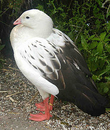
The Andean goose (Chloephaga melanoptera) is a species of waterfowl in tribe Tadornini of subfamily Anserinae. It is found in Argentina, Bolivia, Chile, and Peru. (Full article...)


.jpg)


Did you know...
- ... that the 1930s Polish Andean expeditions have been credited with several first ascents and the tracing of a new route to the summit of Aconcagua, the Andes' highest peak?
Need help?
Do you have a question about Andes that you can't find the answer to?
Consider asking it at the Wikipedia reference desk.
General images
-
 Frederic Edwin Church, Heart of the Andes, 1859. (from Andes)
 -
 View of Cuernos del Paine in Torres del Paine National Park, Chile (from Andes)
 -

-

-
 Paleogeography of the Late Cretaceous South America. Areas subject to the Andean orogeny are shown in light grey while the stable cratons are shown as grey squares. The sedimentary formations of Los Alamitos and La Colonia that formed in the Late Cretaceous are indicated. (from Andean orogeny)
 -
 Irrigating land in the Peruvian Andes (from Andes)
 -
 Nevado del Huila, Colombia (from Andes)
 -
 Pico Humboldt at sunset (from Andes)
 -
 Map of a north-south sea-parallel pattern of rock ages in western Colombia. This pattern is a result of the Andean orogeny. (from Andean orogeny)
 -
 A male Andean cock-of-the-rock, a species found in humid Andean forests and the national bird of Peru (from Andes)
 -

-
 Ulluco: Common crop of the Andean region (from Andean agriculture)
 -
 Simplified sketch of the present-situation along most of the Andes (from Andean orogeny)
 -

-

-

-

-

-
 Central Andes (from Andes)
 -
 Laguna de Sonso tropical dry forest in Northern Andes (from Andes)
 -
 The seaward tilting of the sedimentary strata of Salto del Fraile Formation in Peru was caused by the Andean orogeny. (from Andean orogeny)
 -

-
 Peruvian farmers sowing maize and beans (from Andes)
 -
 Mashua tubers (from Andean agriculture)
 -
 Pacha Mama Ceremony (from Andean agriculture)
 -
 Syncline next to Nordenskjöld Lake in Torres del Paine National Park. The syncline formed during the Andean orogeny. (from Andean orogeny)
 -
 Parinacota, Bolivia/Chile (from Andes)
 -
 Map of the Andean region of South America (from Andean agriculture)
 -
 Bolivian Andes (from Andes)
 -

-

-
 Topographic map of the Andes by the NASA. The southern and northern ends of the Andes are not shown. The Bolivian Orocline is visible as a bend in the coastline and the Andes lower half of the map. (from Andean orogeny)
 -
 Aerial view of Valle Carbajal in the Tierra del Fuego. The Andes range is about 200 km (124 mi) wide throughout its length, except in the Bolivian flexure where it is about 640 kilometres (398 mi) wide. (from Andes)


.jpg)


.jpg)
.jpg)


.jpg)


.JPG)


%E2%80%93Valle_Carbajal_01.jpg)
Subcategories

- Select [►] to view subcategories
Related portals
Subtopics
Associated Wikimedia
The following Wikimedia Foundation sister projects provide more on this subject:
-
 Commons
Free media repository -
 Wikibooks
Free textbooks and manuals -
 Wikidata
Free knowledge base -
 Wikinews
Free-content news -
 Wikiquote
Collection of quotations -
 Wikisource
Free-content library -
 Wikiversity
Free learning tools -
 Wiktionary
Dictionary and thesaurus


