Wikipedia portal for content related to Myanmar (Burma)
ကြိုဆိုပါတယ်။ / Welcome to the Myanmar Portal
Myanmar, officially the Republic of the Union of Myanmar and also known as Burma (the official name until 1989), is a country in Southeast Asia. It is the largest country by area in Mainland Southeast Asia and has a population of about 55 million. It is bordered by Bangladesh and India to its northwest, China to its northeast, Laos and Thailand to its east and southeast, and the Andaman Sea and the Bay of Bengal to its south and southwest. The country's capital city is Naypyidaw, and its largest city is Yangon (formerly Rangoon).
5.5-inch guns of the Royal Artillery firing on Japanese troops attempting to break out of the Sittang Bend in early August 1945
The Battle of the Sittang Bend and the Japanese Breakout across Pegu Yomas were linked Japanese military operations during the Burma Campaign, which took place nearly at the end of World War II. Surviving elements of the Imperial Japanese Army who had been driven into the Pegu Yoma attempted to break out eastwards in order to join other Japanese troops retreating from the British forces. The break-out was the objective of the Japanese Twenty-Eighth Army with support at first from the Thirty-Third Army and later the Fifteenth Army. As a preliminary, the Japanese Thirty-Third Army attacked Allied positions in the Sittang Bend, near the mouth of the river, to distract the Allies. The British had been alerted to the break-out attempt and it ended calamitously for the Japanese, who suffered many losses, with some formations being wiped out.
There were around 14,000 Japanese casualties, with well over half being killed, while British forces suffered only 95 killed and 322 wounded. The break-out attempt and the ensuing battle became the last significant land battle of the Western powers in the Second World War. (Full article...)
Image 2
The military history of Myanmar (Burma) spans over a millennium, and is one of the main factors that have shaped the history of the country, and to a certain degree, the history of Southeast Asia. At various times in history, successive Burmese kingdoms were also involved in warfare against their neighbouring states in the surrounding regions of modern Burmese borders—from Bengal, Manipur and Assam in the west, to Yunnan (the southern China) in the northeast, to Laos and Siam in the east and southeast.
The Royal Burmese Army was a major Southeast Asian armed force between the 11th and 13th centuries and between 16th and 19th centuries. It was the premier military force in the 16th century when the Toungoo dynasty built the largest empire in the history of Southeast Asia. The centuries-long warfare between Burma and Siam (1547–1855) shaped not only the history of both countries but also that of mainland Southeast Asia. In the 18th and early 19th centuries, highly militaristic Konbaung kings had built the largest empire in mainland Southeast Asia until they encountered the British in present-day northeast India. Prior to the three Anglo-Burmese wars (1824–1885), previous existential threats to the country had come from China in the form of Mongol invasions (1277–1301) and Manchu invasions (1765–1769). (Full article...)
Image 3
Censorship in Myanmar (also called Burma) results from government policies in controlling and regulating certain information, particularly on religious, ethnic, political, and moral grounds.
Freedom of speech and the press are not guaranteed by law. Many colonial-era laws regulating the press and information continue to be used. Until August 2012, every publication (including newspaper articles, cartoons, advertisements, and illustrations) required pre-approval by the Press Scrutiny and Registration Division (PSRB) of the Ministry of Information. However, the 2011–2012 Burmese political reforms signalled significant relaxations of the country's censorship policies and in August 2012 the Ministry of Information lifted the requirement that print media organisations submit materials to the government prior to publication. (Full article...)
Image 4
Kyaw Moe Tun in 2022
Kyaw Moe Tun (Burmese: ကျော်မိုးထွန်း; born 28 July 1969) is a Burmese diplomat who currently serves as the Permanent Representative of Myanmar to the United Nations. Prior to his appointment to UN, he had served as director-general of International Organizations and Economic Development Department under the Ministry of Foreign Affairs from 2016 to 2018.
The predecessor to the cyclone caused light to moderate downpour to the Andaman Islands; however, no deaths were reported. Winds reported from the cyclone inland Burma reached an estimate of 60–100 mph, altogether with heavy rainfall and large storm surges. The former flooded the crops, submerging them in floodwaters in the process while the latter washed out villages near the path of the storm. Schools and hospitals throughout Akyab were destroyed by high winds and large waves, while the port suffered major damages. The town was almost destroyed due to the storm. In addition, some ships in the said harbor, including the Greek freighterGeros Michalos were reportedly sunk in the Bay of Bengal. Houses were destroyed during the storm and many livestock died, mainly due to drowning. The death toll from the cyclone was finalized in May 1968 at 1,037 individuals, while 2,000 more were reportedly missing. The property damages were estimated at Ks.15 million ($3.248 million USD). (Full article...)
Image 6
The prehistory of Burma (Myanmar) spanned hundreds of millennia to about 200 BCE. Archaeological evidence shows that the Homo erectus had lived in the region now known as Burma as early as 750,000 years ago, and the Homo sapiens about 11,000 BCE, in a Stone Age culture called the Anyathian. Named after the central dry zone sites where most of the early settlement finds are located, the Anyathian period was when plants and animals were first domesticated and polished stone tools appeared in Burma. Though these sites are situated in fertile areas, evidence shows these early people were not yet familiar with agricultural methods.
The Bronze Age arrived c. 1500 BCE when people in the region were turning copper into bronze, growing rice, and domesticating chickens and pigs. The Iron Age arrived around 500 BCE when iron-working settlements emerged in an area south of present-day Mandalay. Evidence also shows rice growing settlements of large villages and small cities that traded with their surroundings and as far as China between 500 BCE and 200 CE. Bronze-decorated coffins and burial sites filled with the earthenware remains of feasting and drinking provide a glimpse of the lifestyle of their affluent society. (Full article...)
Image 7
Major General Aung San as Minister of Defence, 1943 The Burma Independence Army (BIA) was a pro-Japanese and revolutionary army that fought for the end of British rule in Burma by assisting the Japanese in their conquest of the country in 1942 during World War II. It was the first post-colonial army in Burmese history. The BIA was formed from a group known as the Thirty Comrades under the auspices of the Imperial Japanese Army after training the Burmese nationalists in 1941. The BIA's attempts at establishing a government during the invasion led to it being dissolved by the Japanese and the smaller Burma Defence Army (BDA) formed in its place. As Japan guided Burma towards nominal independence, the BDA was expanded into the Burma National Army (BNA) of the State of Burma, a puppet state under Ba Maw, in 1943.
After secret contact with the British during 1944, on 27 March 1945, the BNA revolted against the Japanese. The army received recognition as an ally from Supreme Allied Commander, Lord Mountbatten, who needed their assistance against retreating Japanese forces and to ease the strain between the army's leadership and the British. As part of the Anti-Fascist People's Freedom League, the BNA was re-labelled the Patriotic Burmese Forces (PBF) during a joint Allied–Burmese victory parade in Rangoon on 23 June 1945. Following the war, after tense negotiations, it was decided that the PBF would be integrated into a new Burma Army under British control, but many veterans would continue under old leadership in the paramilitary People's Volunteer Organisation (PVO) in the unstable situation of post-war Burma. (Full article...)
In mid-eighteenth century, after the fall of Burmese Toungoo dynasty at the hands of the Mons of Hanthawaddy, Burma under the new Konbaung dynasty emerged powerful. Burma, under King Alaungpaya the dynasty's founder, aspired to expand onto its traditional sphere of influence. After learning of Siamese provocations, King Alaungpaya and his Burmese forces of 40,000 men, with his son Prince of Myedu as vanguard commander, invaded Siam in late 1759 to early 1760. The Burmese reached and attacked Ayutthaya in April 1760 but the arrival of rainy season and sudden illness of Alaungpaya prompted the Burmese to retreat. Traditional Siamese strategy of passive stand in Ayutthaya citadel against Burmese besiegers worked for one last time, postponing the eventual fall of Ayutthaya for seven years. The Burmese king and dynasty founder Alaungpaya died on May 1760 on his way from Siam back to Burma. Burmese invasion of Siam in 1760, in which the Burmese, particularly Prince Myedu, had an opportunity to learn about Siamese geography, strategy and tactics and to reflect about their own flaws in the campaign, served as the foundation of the next Burmese invasion in 1765–1767. Prince Myedu, with his experience as the vanguard commander during the war of 1760, ascended the Burmese throne as King Hsinbyushin in late 1763. Hsinbyushin inherited military energy and prowess from his father Alaungpaya and was determined to accomplish the unfinished mission of conquering Ayutthaya unattained by his father. (Full article...)
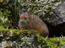
Image 9
Forrest's pika (Ochotona forresti) is a species of mammal in the pika family, Ochotonidae. It is found in Bhutan, China, India, and Myanmar. The summer dorsal pelage and ventral pelage are dark rufous or blackish brown, and the winter dorsal pelage is a grayish brown, slightly lighter in tone than the ventral pelage. It is a generalist herbivore. It was assessed by the IUCN Red List of Endangered Species as insufficiently known in 1994, as near threatened in 1996, and re-assessed in 2008 as a species of least concern. (Full article...)
Image 10
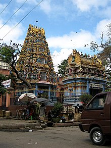
Shri Kali Temple, Burma, a Hindu temple with Dravidian architecture in YangonBurmese Indians are a group of people of Indian origin who live in Myanmar (Burma). The term 'Burmese Indian' refers to a broad range of people from South Asia, most notably from present-day countries such as India and Bangladesh. While Indians have lived in Burma for many centuries, most of the ancestors of the current Burmese Indian community emigrated to Burma from the start of British rule in the mid-19th century to the separation of British Burma from British India in 1937. During colonial times, ethnic Indians formed the backbone of the government and economy serving as soldiers, civil servants, merchants, moneylenders, mobile laborers and dock workers. A series of anti-Indian riots in the 1930s and mass emigration at the onset of the Japanese invasion of Burma in 1942 were followed in the 1960s by the forced migration of hundreds of thousands of ethnic Indians, exacerbated by internal conflict in Myanmar.
Burmese Indians today are estimated to account for approximately 5% (about 2.0–2.5 million people) of the population of Burma and are concentrated largely in the two major cities (Yangon and Mandalay) and former colonial towns (Pyin U Lwin and Kalaw). They wield considerable influence and control over the Burmese economy and have a major socio-cultural presence within the country. Amongst the well-known Burmese Indians is S N Goenka, a leading practitioner and teacher of vipassanā meditation and Helen, a well-known Bollywood film actress who is also of Anglo-Burmese descent. (Full article...)
... that clashes between the Myanmar military and local armed groups broke out in Lay Kay Kaw six years after it was established as a "town of peace" between the parties?
The following are images from various Myanmar-related articles on Wikipedia.
Image 1Pagan Kingdom during Narapatisithu's reign. Burmese chronicles also claim Kengtung and Chiang Mai. Core areas shown in darker yellow. Peripheral areas in light yellow. Pagan incorporated key ports of Lower Burma into its core administration by the 13th century. (from History of Myanmar)
Image 19British soldiers dismantling cannons belonging to King Thibaw's forces, Third Anglo-Burmese War, Ava, 27 November 1885. Photographer: Hooper, Willoughby Wallace (1837–1912). (from History of Myanmar)
Image 20Salween river at Mae Sam Laep on the Thai-Myanmar border (from Geography of Myanmar)
Image 21Political Map of Burma (Myanmar) c. 1450 CE. (from History of Myanmar)
Image 22British soldiers on patrol in the ruins of the Burmese town of Bahe during the advance on Mandalay, January 1945. (from History of Myanmar)
Image 25Vegetable stall on the roadside at the Madras Lancer Lines, Mandalay, January 1886. Photographer: Hooper, Willoughby Wallace (1837–1912). (from History of Myanmar)
Image 31Two female musicians play the saung at a performance in Mandalay. (from Culture of Myanmar)
Image 32The paddle steamer Ramapoora (right) of the British India Steam Navigation Company on the Rangoon river having just arrived from Moulmein. 1895. Photographers: Watts and Skeen (from History of Myanmar)
Image 37A wedding procession, with the groom and bride dressed in traditional Burmese wedding clothes, reminiscent of royal attire (from Culture of Myanmar)
Image 38Boxing match, 19th-century watercolour (from Culture of Myanmar)
Image 40British soldiers remove their shoes at the entrance of Shwedagon Pagoda. To the left, a sign reads "Foot wearing is strictly prohibited" in Burmese, English, Tamil, and Urdu. (from Culture of Myanmar)


_(cropped).png)


_map_-_EN_-_001.jpg)


 Pagan Kingdom during Narapatisithu's reign. Burmese chronicles also claim Kengtung and Chiang Mai. Core areas shown in darker yellow. Peripheral areas in light yellow. Pagan incorporated key ports of Lower Burma into its core administration by the 13th century. (from History of Myanmar)
 Temples at Mrauk U, was the capital of the Mrauk U Kingdom, which ruled over what is now Rakhine State. (from History of Myanmar)
 A bull fight, 19th-century watercolour (from Culture of Myanmar)
 Portuguese ruler and soldiers mounting an Elephant. Philips, Jan Caspar (draughtsman and engraver) (from History of Myanmar)
 A theatrical performance of the Mon dance (from Culture of Myanmar)
 Saint Mary's Cathedral in Downtown Yangon is the largest Roman Catholic cathedral in Burma. (from Culture of Myanmar)
 Recorder's Court on Sule Pagoda Road, with the Sule Pagoda at the far end, Rangoon, 1868. Photographer: J. Jackson. (from History of Myanmar)
 A wide range of Burmese lacquerware from Bagan (from Culture of Myanmar)
 Protesters in Yangon carrying signs reading "Free Daw Aung San Suu Kyi" on 8 February 2021. (from History of Myanmar)
 19th-century funeral cart and spire, which would form part of the procession from the home to the place of cremation (from Culture of Myanmar)
 Mountains near Pindaya on the Shan Plateau (from Geography of Myanmar)
 A group of Buddhist worshipers at Shwedagon Pagoda, an important religious site for Burmese Buddhists (from Culture of Myanmar)
 Aung San Suu Kyi addresses crowds at the NLD headquarters shortly after her release. (from History of Myanmar)
 Myanmar (Burma) map of Köppen climate classification (from Geography of Myanmar)
 The shores of Irrawaddy River at Nyaung-U, Bagan (from Geography of Myanmar)
 Jade Mine in Hpakant (from Geography of Myanmar)
 A large fracture on the Mingun Pahtodawgyi caused by the 1839 Ava earthquake. (from Geography of Myanmar)
 British soldiers dismantling cannons belonging to King Thibaw's forces, Third Anglo-Burmese War, Ava, 27 November 1885. Photographer: Hooper, Willoughby Wallace (1837–1912). (from History of Myanmar)
 Salween river at Mae Sam Laep on the Thai-Myanmar border (from Geography of Myanmar)
 Political Map of Burma (Myanmar) c. 1450 CE. (from History of Myanmar)
 British soldiers on patrol in the ruins of the Burmese town of Bahe during the advance on Mandalay, January 1945. (from History of Myanmar)

 Vegetable stall on the roadside at the Madras Lancer Lines, Mandalay, January 1886. Photographer: Hooper, Willoughby Wallace (1837–1912). (from History of Myanmar)
 Hlei pyaingbwè - a Burmese regatta (from Culture of Myanmar)
 The restored Taungoo or Nyaungyan dynasty c. 1650 CE. (from History of Myanmar)
 Myinhkin thabin - equestrian sport (from Culture of Myanmar)
 Former US President Barack Obama poses barefoot on the grounds of Shwedagon Pagoda, one of Myanmar's major Buddhist pilgrimage sites. (from Culture of Myanmar)
 Two female musicians play the saung at a performance in Mandalay. (from Culture of Myanmar)
 The paddle steamer Ramapoora (right) of the British India Steam Navigation Company on the Rangoon river having just arrived from Moulmein. 1895. Photographers: Watts and Skeen (from History of Myanmar)
 Grandfather Island, Dawei (from Geography of Myanmar)
 Protesters in Yangon with a banner that reads non-violence: national movement in Burmese, in the background is Shwedagon Pagoda. (from History of Myanmar)
 Sculpture of Myanmar mythical lion (from Culture of Myanmar)
 Aerial view of a burned Rohingya village in Rakhine state, Myanmar, September 2017 (from History of Myanmar)
 A wedding procession, with the groom and bride dressed in traditional Burmese wedding clothes, reminiscent of royal attire (from Culture of Myanmar)
 Boxing match, 19th-century watercolour (from Culture of Myanmar)
 Mount Popa, a dormant volcano in the Central Lowlands (from Geography of Myanmar)
 British soldiers remove their shoes at the entrance of Shwedagon Pagoda. To the left, a sign reads "Foot wearing is strictly prohibited" in Burmese, English, Tamil, and Urdu. (from Culture of Myanmar)


_headquarter.jpg)


 Commons
 Wikibooks
 Wikidata
 Wikinews
 Wikiquote
 Wikisource
 Wikiversity
 Wikivoyage
 Wiktionary


