
User:Ɱ/Portal:Columbus, Ohio
Portal maintenance status: (October 2021)
|
Introduction

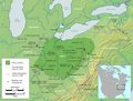
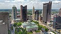
Columbus (/kəˈlʌmbəs/, kə-LUM-bəs) is the capital and most populous city of the U.S. state of Ohio. With a 2020 census population of 905,748, it is the 14th-most populous city in the U.S., the second-most populous city in the Midwest after Chicago, and the third-most populous U.S. state capital after Phoenix, Arizona and Austin, Texas. Columbus is the seat of government of Franklin County; it also extends into Delaware and Fairfield counties. It is the core city of the Columbus metropolitan area, which encompasses ten counties in central Ohio. It had a population of 2,138,926 in 2020, making it the largest metropolitan area entirely in Ohio and 32nd-largest metro area in the U.S.
Columbus originated as numerous Native American settlements on the banks of the Scioto River. Franklinton, now a city neighborhood, was the first European settlement, laid out in 1797. The city was founded in 1812 at the confluence of the Scioto and Olentangy rivers, and laid out to become the state capital. The city was named for Italian explorer Christopher Columbus. The city assumed the function of state capital in 1816 and county seat in 1824. Amid steady years of growth and industrialization, the city has experienced numerous floods and recessions. Beginning in the 1950s, Columbus began to experience significant growth; it became the largest city in Ohio in land and population by the early 1990s. Growth has continued in the 21st century, with redevelopment occurring in numerous city neighborhoods, including Downtown. (Full article...)
Selected general articles
-

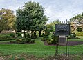
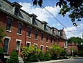
The Old Beechwold Historic District is a neighborhood and historic district in Clintonville, Columbus, Ohio. The site was listed on the Columbus Register of Historic Properties in 1985 and the National Register of Historic Places in 1987. The district is significant for its architecture, landscape architecture, and community planning. The houses are of the early 20th century, using stone, brick, and stucco.
The land was originally part of a large tract owned by a single family, but in 1902, 75 of those acres were sold to the Columbus Zoological Company. The company established one of the first zoos in Columbus, known as "The Zoo", that failed after only five months, opening in May and closing in November of 1905. In 1906, Joseph A. Jeffrey acquired the land, and created a suburban estate named "Beechwalde". He built the two oldest houses in the district. The former monkey house can still be seen on the property of 150 West Beechwold Boulevard where it is used as a barn. The zoo's original brick entrance can also be seen on North High Street at Beechwold Road. (Full article...) -

Bolton Field (ICAO: KTZR, FAA LID: TZR) is a public airport in Columbus, Franklin County, Ohio, United States. It is a towered airport operated under the Columbus Regional Airport Authority. It is one of 12 general aviation reliever airports in Ohio recognized in the National Plan of Integrated Airport Systems (NPIAS) and is a reliever airport for John Glenn Columbus International Airport.
Most U.S. airports use the same three-letter location identifier for the FAA and IATA, but Bolton Field is TZR to the FAA and has no IATA code. (Full article...) -
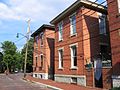
Victorian Village is a neighborhood in Columbus, Ohio, United States, north and near west of downtown. It is an established neighborhood built when a streetcar line first ran along Neil Avenue around 1900 with a fair number of established trees for an urban setting. To preserve, protect and enhance the unique architectural and historical features, the Victorian Village Historic District was established in 1973. Columbus Monthly named this neighborhood the top place to live for Arts and Entertainment, with fun right around the corner in the Short North as its neighborhood hangout. (Full article...) -
Argyle Park is an area near North Central Columbus, Ohio, bounded by East Hudson Street on the north, Woodland Avenue on the east, East 17th and East 26th avenues on the south, and Billiter Boulevard on the west. (Full article...)
-
South Columbus also referred to as the "South Side" or the "South End", consists of numerous urban and suburban areas south of Downtown Columbus, Ohio, United States. It is part of the native Columbus geographical terminology of the large residential urban communities outside Downtown, including German Village, Schumacher Place, and the Brewery District. South Columbus is defined as the entire southeastern portion of Columbus, bordered by the Scioto River to the west, bounded by Interstate 70 to the north, and includes the southern city limit municipalities beyond the I-270 outerbelt, such as Groveport, Lockbourne, Obetz, and the Rickenbacker International Airport.
The City of Columbus has designated portions of the South Side as a Community Reinvestment Area that is "ready for revitalization", with available 15-year, 100 percent tax abatements for all projects that include 10 percent affordable housing, with options to buy out of the requirement. (Full article...) -
Harrison West is a historic urban neighborhood located northwest of downtown Columbus, Ohio. It sits on several blocks along the Olentangy River and includes the western part of the Near Northside Historic District, which was placed on the National Register of Historic Places in 1975. The character of the neighborhood is similar to Victorian Village, which sits just to the east and is more well-known. (Full article...) -
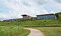
Ohio Dominican University is a private Dominican liberal arts university in Columbus, Ohio. In 2024, the university had 1,252 students and offered undergraduate degrees in 42 majors as well as 9 graduate degree programs. (Full article...)
-
Valleyview is a village in Franklin County, Ohio, United States. The population was 669 at the 2020 census. (Full article...) -
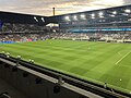
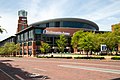
The Columbus Blue Jackets (often simply referred to as the Jackets) are a professional ice hockey team based in Columbus, Ohio. The Blue Jackets compete in the National Hockey League (NHL) as a member of the Metropolitan Division in the Eastern Conference, and began play as an expansion team in 2000.
The franchise struggled in their initial years, failing to win 30 games in a season until 2005–06. The team qualified for the Stanley Cup playoffs for the first time in 2009, but were swept by the Detroit Red Wings. Columbus ultimately notched their first playoff game victory in the 2014 playoffs, and won their first playoff series in the 2019 playoffs against the Tampa Bay Lightning, becoming the first team in NHL history to sweep a Presidents' Trophy winner in the first round. Along with the Seattle Kraken, the Blue Jackets are one of only two teams in the league who have yet to appear in the conference finals.
The Blue Jackets' name and logos are inspired by Ohio's Civil War history. The Blue Jackets play their home games at Nationwide Arena in downtown Columbus, which opened in 2000. They are affiliated with the Cleveland Monsters of the AHL. (Full article...) -
Holly Hill is a neighborhood located in West Columbus, Columbus, Ohio, United States. Holly Hill is a traditional 1960s suburban neighborhood consisting of mostly brick ranch houses and some bi-level houses. The houses range in size from approximately 860 square feet (80 m2) up to 1,500 square feet (140 m2). Holly Hill is located next to Georgian Heights. (Full article...)
-

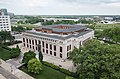
The Columbus Metropolitan Library (CML) is a public library system in Franklin County, Ohio, in the Columbus metropolitan area. The library serves an area of 872,000 residents, has a collection of 1,483,433 volumes, and circulates 17,262,267 items per year.
The library consists of the Main Library and 22 branches located in neighborhoods throughout Franklin County. The branches are Canal Winchester, Driving Park, Dublin, Franklinton, Gahanna, Hilliard, Hilltop, Karl Road, Linden, Livingston, Marion-Franklin, Martin Luther King, New Albany, Northern Lights, Northside, Parsons, Reynoldsburg, Shepard, South High, Southeast, Whetstone, and Whitehall. CML also jointly operates the Northwest Library in cooperation with Worthington Libraries. Columbus Metropolitan Library is a member of the Central Library Consortium, which enables its 17-member library systems to share a catalog. (Full article...) -
Glen Echo is a neighborhood located in the far northern part of the University District in Columbus, Ohio. The area was listed on the National Register of Historic Places in 1997. The name Glen Echo refers to Glen Echo Ravine, which runs along the northern edge of the neighborhood. Principal streets in the area are Glen Echo Drive, Summit Street, Glenmawr Avenue, North Fourth Street, Arcadia, Cliffside Drive, and more. One street, Parkview Drive, was platted in the ravine basin, but was later abandoned.
The district originated in 1909 when the Columbus Real Estate and Improvement Company platted 47 acres (19 ha) as "Indianola Park View" for a planned residential subdivision and a part of the Glen Echo Ravine was delineated as a park, the first such donation to the city of Columbus by a real estate developer. The wooded Glen Echo Ravine significantly influenced the original layout, design, and overall character of the district. The neighborhood's developer was also involved with the development of Walhalla Ravine and Eastgate. Prior to its development, the area was considered for a major hospital; however, those plans were abandoned.
A 1909 Ohio State publication described the new north side park as a place of beauty where large oak and elm trees shaded a wading pond, five small lakes connected by a single stream, rustic benches, foot bridges and springs lined with cobblestones. Glen Echo's picturesque environs hosted picnic dinners, equestrians and motorists who enjoyed this oasis of greenery. In 1910 the development was annexed to the City of Columbus and in 1912 Glen Echo Park was dedicated to the city. (Full article...) -
Broad Street is a major thoroughfare in Central Ohio, predominantly in Franklin County and Columbus. It stretches east from West Jefferson at Little Darby Creek to Pataskala. The street is considered one of Columbus's two main roads, along with High Street.
Broad Street was first laid out around 1797, when Franklinton was settled. In 1812, when Columbus was founded, a new section of the street was built in the new city. The street first connected to the rest of the settled country in 1831, when the Ohio and Erie Canal reached Columbus. In 1833, the National Road was extended to Columbus, utilizing all of West Broad Street. In the mid-to-late 19th century, East Broad Street became a fashionable place for wealthy homeowners, and large mansions were built along the tree-lined street. Large hotels and apartments followed into the early 1900s. The street has seen numerous changes since then, including clearing and widening. Portions of the street were improved with trees, bike lanes, and rainwater basins in Franklinton, with additional streetscape improvements planned for other sections of the street. (Full article...) -

Ohio History Connection, formerly The Ohio State Archaeological and Historical Society and Ohio Historical Society, is a nonprofit organization incorporated in 1885. Headquartered at the Ohio History Center in Columbus, Ohio, Ohio History Connection provides services to both preserve and share Ohio's history, including its prehistory, and manages over 50 museums and sites across the state. An early iteration of the organization was founded by Brigadier General Roeliff Brinkerhoff in 1875. Over its history, the organization changed its name twice, with the first occurring in 1954 when the name was shortened to Ohio Historical Society. In 2014, it was changed again to Ohio History Connection, in what members believed was a more modern and welcoming representation of the organization's image. (Full article...) -
The Ohio Statehouse is the state capitol building and seat of government for the U.S. state of Ohio. The Greek Revival building is located on Capitol Square in Downtown Columbus. The capitol houses the Ohio General Assembly, consisting of the House of Representatives and the Senate. It also contains the ceremonial offices of the governor, lieutenant governor, state treasurer, and state auditor. Built between 1839 and 1861, it is one of the oldest working statehouses in the United States. The statehouse grounds include two other buildings, the Judiciary Annex or Senate Building, and the Atrium; the three are collectively referred to as the Ohio Statehouse into the present day.
The statehouse's prominent architecture has earned it several landmark designations, including as a National Historic Landmark. The building sees about 500,000 visitors per year. (Full article...) -

The Columbus Civic Center features government buildings lining the Scioto Mile and River
The Columbus Civic Center is a civic center, a collection of government buildings, museums, and open park space in Downtown Columbus, Ohio. The site is located along the Scioto Mile recreation area and historically was directly on the banks of the Scioto River.
The civic center includes Columbus City Hall, the Ohio Judicial Center, Central High School (now the COSI science museum), the Joseph P. Kinneary United States Courthouse, and the former Central Police Station. It also included the Scioto River Bridge Group. Also sometimes included in the civic center are the LeVeque Tower and newer government office additions to the area, including the Front Street office buildings, the since-demolished Franklin County Veterans Memorial and Columbus Public Health office in Franklinton, as well as the newer Michael B. Coleman Government Center and current Columbus Division of Police Headquarters.
Following a local version of the City Beautiful movement, the Columbus Plan first envisioned a riverfront civic center in 1908. The Great Flood of 1913 destroyed many riverfront structures, allowing the opportunity to redevelop according to the 1908 plan. Columbus's most prominent architect, Frank Packard, spearheaded the project until his unexpected death in 1923. The Neoclassical, Renaissance Revival, and Art Deco buildings, bridges, and retaining wall were built from 1917 to 1934. In 1988, the area was nominated to the National Register of Historic Places as the Columbus Civic Center Historic District. (Full article...) -
Worthington is a city in Franklin County, Ohio, United States, and is a northern suburb of Columbus. The population in the 2020 Census was 14,786. The city was founded in 1803 by the Scioto Company led by James Kilbourne, who was later elected to the United States House of Representatives, and named in honor of Thomas Worthington, who later became governor of Ohio. (Full article...) -

1884 Columbus Buckeyes
The Columbus Buckeyes were a professional baseball team in the American Association from 1883 to 1884. In two seasons they won 101 games and lost 104 for a winning percentage of .493. Their home games were played at Recreation Park in Columbus, Ohio.
The Buckeyes were managed by Horace Phillips in 1883 (32-65) and Gus Schmelz in 1884 (69-39). Some of their top players were pitchers Ed "Cannonball" Morris, Frank Mountain, and Ed Dundon, the first deaf player in the major leagues, and outfielder Tom Brown.
In 1884, the Buckeyes threw two no-hitters in the span of a week. Morris pitched his on May 29 and Mountain threw one on June 5. (Full article...) -

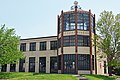
Ohio State School for the Blind (OSSB or OSB) is a school located in Columbus, Ohio, United States. It is run by the Ohio Department of Education for blind and visually impaired students across Ohio. It was established in 1837, making it the nation's first public school for the visually impaired.
The Ohio Institution for the Education of the Blind building was constructed in 1874 in downtown Columbus on Parsons Ave. Later it became the headquarters for the Ohio State Highway Patrol, and is now home to the Columbus Public Health offices. In the early 1900s, the Ohio Institution for the Education of the Blind became known as the Ohio State School for the Blind. In the mid-1950s the school moved to its current location at 5220 N. High St on the ground of a defaulted golf course. Over its history, the school has seen a vast change in its population and demographics, originally housing a majority of single disability student to now educating students with a variety of abilities.
In the basement of the school sits a vast collection of models that were constructed and purchased over time, of various monuments around the United States that blind students may not be able to see with their eyes but instead could examine with their hands. While the majority of the models were constructed of quality material, there are some that have been neglected and damaged over the years. And have such been repaired and sit in the lobby of the newly built building. (Full article...) -
The community of Forest Park consists of almost 2900 private residential properties (single-family homes and duplexes), plus apartments, condominiums, commercial properties, city-owned parks and schools, in approximately 1.4 square miles (3.6 km2) of the Northland area of northeast Columbus, Ohio. These properties adjoin a total of 132 distinct streets and courts maintained by the City of Columbus. The community's approximate center is near the intersection of Karl Road and Sandalwood Place in Columbus. (Full article...)
-

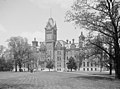
The Ohio State University (Ohio State or OSU) is a public land-grant research university in Columbus, Ohio, United States. A member of the University System of Ohio, it was founded in 1870. It is one of the largest universities by enrollment in the United States, with nearly 50,000 undergraduate students and nearly 15,000 graduate students. The university consists of sixteen colleges and offers over 400 degree programs at the undergraduate and graduate levels.
It is classified among "R1: Doctoral Universities – Very high research activity". the university has an endowment of $7.4 billion. Its athletic teams compete in NCAA Division I as the Ohio State Buckeyes as a member of the Big Ten Conference for the majority of fielded sports.
It is a member of the Association of American Universities. Past and present alumni and faculty include 6 Nobel Prize laureates, 9 Rhodes Scholars, 7 Churchill Scholars, 1 Fields Medalist, 7 Pulitzer Prize winners, 64 Goldwater scholars, 7 U.S. senators, 15 U.S. representatives, 104 Olympic medalists, and 1 foreign head of state. (Full article...) -
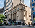
The Lincoln Theatre is a 582-seat performing arts venue located at 769 E. Long Street in the King-Lincoln Bronzeville neighborhood of Columbus, Ohio. The theater is owned by the City of Columbus under the auspices of the Lincoln Theatre Association. Operation of the facility is managed by CAPA. It was listed on the National Register of Historic Places in 1992. (Full article...) -

The Central Ohio Transit Authority (COTA /ˈkoʊtə/) is a public transit agency serving the Columbus metropolitan area, headquartered in Columbus, Ohio. It operates fixed-route buses, bus rapid transit, microtransit, and paratransit services.
COTA's headquarters are located in the William J. Lhota Building in downtown Columbus. The agency is managed by President and CEO Joanna Pinkerton along with a 13-member board of trustees. COTA is funded by a permanent 0.25% sales tax as well as another 10-year 0.25% sales tax.
The agency was founded in 1971, replacing the private Columbus Transit Company. Mass transit service in the city dates to 1863, progressively with horsecars, streetcars, and buses. The Central Ohio Transit Authority began operating in 1974 and has made gradual improvements to its fleet and network. Its first bus network redesign took place in 2017. (Full article...) -

DeVry University (/dəˈvraɪ/) is a privately owned for-profit university with its headquarters in Naperville, Illinois. It was founded in 1931 by Herman A. DeVry and is accredited by the Higher Learning Commission. DeVry is predominantly an online educator but does have campuses in the United States. (Full article...) -

King-Lincoln Bronzeville is a historically African American neighborhood in Columbus, Ohio. Originally known as Bronzeville by the residents of the community, it was renamed the King-Lincoln District by Mayor Michael B. Coleman's administration to highlight the historical significance of the district's King Arts Complex and Lincoln Theatre, amid collaborations with investors and developers to revitalize the neighborhood.
In 2009, the King-Lincoln Bronzeville Neighborhood Association asked that the neighborhood be renamed to Bronzeville to reflect its history. (Full article...)


.jpg)


Need help?
Do you have a question about Columbus, Ohio that you can't find the answer to?
Consider asking it at the Wikipedia reference desk.
Selected images
-
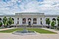
 Central Market, pictured here in 1898, operated from 1814 to 1966. (from Columbus, Ohio)
 -
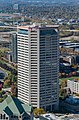
 The Art Deco LeVeque Tower is the city's second-tallest skyscraper. (from Columbus, Ohio)
 -
 Racial distribution in Columbus in 2010: ⬤ White ⬤ Black ⬤ Asian ⬤ Hispanic ⬤ Other (from Columbus, Ohio)
 -
-
 Dutch Colonial Style residences in Hungarian Village (from Neighborhoods in Columbus, Ohio)
 -
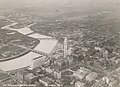
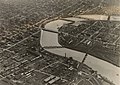 Downtown Columbus and the Scioto River c. 1924 (from Columbus, Ohio)
 -
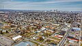 Aerial view of Reeb-Hosack (from Neighborhoods in Columbus, Ohio)
 -
 Shrum Mound in Campbell Memorial Park (from Columbus, Ohio)
 -
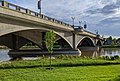 The Discovery Bridge (from Columbus, Ohio)
 -

-
 Municipal offices, including the Columbus Division of Police Headquarters, in the city's Civic Center (from Columbus, Ohio)
 -
 Map of the Ohio Country between 1775 and 1794, depicting locations of battles and massacres surrounding the area that would eventually become Ohio (from History of Columbus, Ohio)
 -
-
-
 Skyline of Columbus (Use cursor to identify buildings) (from List of tallest buildings in Columbus, Ohio)
 -
 Map of land surveys and city boundary growth, 1812–1920 (from History of Columbus, Ohio)
 -
 Lou Berliner Sports Park (from List of parks in Columbus, Ohio)
 -
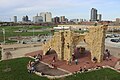
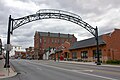 Old North Columbus Arch (from Neighborhoods in Columbus, Ohio)
 -
-
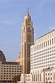 The LeVeque Tower was the tallest building in Columbus from 1927 to 1973. (from List of tallest buildings in Columbus, Ohio)
 -
 Camp Chase as it stands today, a memorial to fallen soldiers from the American Civil War. (from Neighborhoods in Columbus, Ohio)
 -
 North Market (from Columbus, Ohio)
 -
 The Santa Maria Ship & Museum, a Santa María replica, was docked downtown from 1991 to 2014. (from Columbus, Ohio)
 -

-
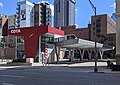 COTA's Spring Street Terminal, one of its five transit centers (from Columbus, Ohio)
 -
 The Merion Village arch (from Neighborhoods in Columbus, Ohio)
 -
 View of the city from Capital University in 1854 (from History of Columbus, Ohio)
 -
 Eastern side of Olentangy Commons (from Neighborhoods in Columbus, Ohio)
 -
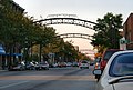 The iconic arches of the Short North (from Neighborhoods in Columbus, Ohio)
 -
-
 Homes in German Village (from Neighborhoods in Columbus, Ohio)
 -

-
Central Market stood on Fourth Street from 1850 to 1966 (from History of Columbus, Ohio)
-
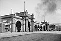
 Arcade of the third Union Station, the city's rail station from 1897 to 1977 (from Columbus, Ohio)
 -
-

-
Map of the Ohio Country between 1775 and 1794, depicting locations of battles and massacres surrounding the area that would eventually become the U.S. state of Ohio (from Columbus, Ohio)
-

-
 Columbus City Hall (from Columbus, Ohio)
 -
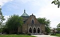
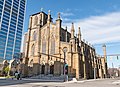
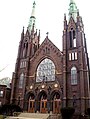 Holy Rosary and Saint John Church (from Neighborhoods in Columbus, Ohio)
 -
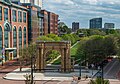 Located in the Arena District, McFerson Commons is home to the Union Station arch. (from Columbus, Ohio)
 -
 Aerial satellite image of Columbus (from Columbus, Ohio)
 -
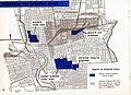 1954 urban renewal map of Columbus (from List of demolished buildings and structures in Columbus, Ohio)
 -
 Home in Old Oaks (from Neighborhoods in Columbus, Ohio)
 -
 Locations of numbered streets and avenues (from Columbus, Ohio)
 -
 Panorama of downtown Columbus from the Main Street Bridge (from Columbus, Ohio)
 -
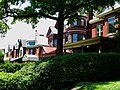 Victorian-style homes located along Goodale Park (from Neighborhoods in Columbus, Ohio)
 -
Shrum Mound, the feature of Campbell Memorial Park (from History of Columbus, Ohio)
-
 Historic Home in Harrison West (from Neighborhoods in Columbus, Ohio)
 -

-
 The city in 1936 (from Columbus, Ohio)
 -
 Brewery District Scene (from Neighborhoods in Columbus, Ohio)
 -
 Street arches returned to the Short North in late 2002. (from History of Columbus, Ohio)
 -
 Four of the city's five tallest buildings are around Capitol Square (from List of tallest buildings in Columbus, Ohio)
 -
 COSI (east entrance pictured) features themed, interactive science exhibits. (from Columbus, Ohio)
 -
 The Ohio State Fair is held in late July to early August. (from Columbus, Ohio)
 -
 Bird's eye view map of Columbus in 1872 (from History of Columbus, Ohio)
 -
-
 The Pontifical College Josephinum (1888-1931) (from List of demolished buildings and structures in Columbus, Ohio)
 -
 The Scioto Mile includes nine parks along both banks of the Scioto River between downtown Columbus and Franklinton. (from Columbus, Ohio)
 -

-
 Barlouie (from Neighborhoods in Columbus, Ohio)
 -
 Big Run Sports Complex, in Big Run Park (from Neighborhoods in Columbus, Ohio)
 -

-
The city c. 1924 (from History of Columbus, Ohio)
-
 Victorian houses facing Goodale Park in Victorian Village (from Columbus, Ohio)
 -
 West Broad Street in Franklinton (from Neighborhoods in Columbus, Ohio)
 -
-
View of the city from Capital University in 1854 (from Columbus, Ohio)
-
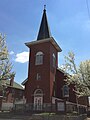 Hungarian Reform Church, in Hungarian Village (from Neighborhoods in Columbus, Ohio)
 -

-
-
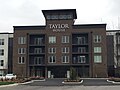 Taylor House on Bethel Rd. (from Neighborhoods in Columbus, Ohio)
 -
-

-

-
 Hilltop signage (from Neighborhoods in Columbus, Ohio)
 -
 Italian Village rowhouse (from Neighborhoods in Columbus, Ohio)
 -
 Ohio Stadium, on the campus of Ohio State University, is the 5th-largest non-racing stadium in the world. (from Columbus, Ohio)
 -
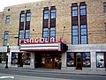 The historic Lincoln Theatre (from Neighborhoods in Columbus, Ohio)
 -
Bird's eye view map of Columbus in 1872 (from Columbus, Ohio)
-
 Audubon nature center at Scioto Audubon Metro Park, the first built close to a major city's downtown (from Columbus, Ohio)
 -
 Port Columbus Airport tower and terminal from 1929 to 1958 (from Columbus, Ohio)
 -
 Indianola Junior High School was the first middle school in the U.S. (from Columbus, Ohio)
 -
-
 St. Mary Magdalene Church in Westgate (from Neighborhoods in Columbus, Ohio)
 -
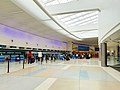 John Glenn Columbus International Airport departure level (from Columbus, Ohio)
 -
2010 Census-based map: red dots indicate white Americans, blue dots for African Americans, green for Asian Americans, orange for Hispanic Americans, yellow for other races. Each dot represents 25 residents. (from Neighborhoods in Columbus, Ohio)
-
 The Columbus Museum of Art collects and exhibits American and European modern and contemporary art, folk art, glass art, and photography. (from Columbus, Ohio)
 -
Columbus in 1936 (from History of Columbus, Ohio)
-


.png)


.jpg)


_crop.jpg)


.jpg)


.jpg)

.jpg)
_-_exterior_2.jpg)


.jpg)
Subcategories

- Select [►] to view subcategories
Subtopics
| Topics |  | ||||||
|---|---|---|---|---|---|---|---|
| Neighborhoods | |||||||
| Enclaves | |||||||
| History |
| ||||||
| Attractions | |||||||
| Government |
| ||||||
| Education |
| ||||||
| Transportation |
| ||||||
| Sports |
| ||||||
| Museums |
| ||||||
| |||||||
Associated Wikimedia
The following Wikimedia Foundation sister projects provide more on this subject:
-
 Commons
Free media repository -
 Wikibooks
Free textbooks and manuals -
 Wikidata
Free knowledge base -
 Wikinews
Free-content news -
 Wikiquote
Collection of quotations -
 Wikisource
Free-content library -
 Wikiversity
Free learning tools -
 Wiktionary
Dictionary and thesaurus
Category:United States portals by city Category:Portals needing placement of incoming links