
Portal:World
The World Portal


The world is the totality of entities, the whole of reality, or everything that exists. The nature of the world has been conceptualized differently in different fields. Some conceptions see the world as unique while others talk of a "plurality of worlds". Some treat the world as one simple object while others analyze the world as a complex made up of parts.
In scientific cosmology, the world or universe is commonly defined as "[t]he totality of all space and time; all that is, has been, and will be". Theories of modality talk of possible worlds as complete and consistent ways how things could have been. Phenomenology, starting from the horizon of co-given objects present in the periphery of every experience, defines the world as the biggest horizon or the "horizon of all horizons". In philosophy of mind, the world is contrasted with the mind as that which is represented by the mind. Theology conceptualizes the world in relation to God, for example, as God's creation, as identical to God or as the two being interdependent. In religions, there is a tendency to downgrade the material or sensory world in favor of a spiritual world to be sought through religious practice. A comprehensive representation of the world and our place in it, as is found in religions, is known as a worldview. Cosmogony is the field that studies the origin or creation of the world while eschatology refers to the science or doctrine of the last things or of the end of the world.
In various contexts, the term "world" takes a more restricted meaning associated, for example, with the Earth and all life on it, with humanity as a whole or with an international or intercontinental scope. In this sense, world history refers to the history of humanity as a whole and world politics is the discipline of political science studying issues that transcend nations and continents. Other examples include terms such as "world religion", "world language", "world government", "world war", "world population", "world economy", or "world championship". (Full article...)
Selected articles -
-


Lac Gentau in the Ossau Valley of the Pyrenees, France
A lake is an often naturally occurring, relatively large and fixed body of water on the Earth's surface. It is localized in a basin or interconnected basins surrounded by dry land. Lakes lie completely on land and are separate from the ocean, although they may be connected with the ocean by rivers, such as Lake Ontario. Most lakes are freshwater and account for almost all the world's surface freshwater, but some are salt lakes with salinities even higher than that of seawater. Lakes vary significantly in surface area and volume.
Lakes are typically larger and deeper than ponds, which are also water-filled basins on land, although there are no official definitions or scientific criteria distinguishing the two. Lakes are also distinct from lagoons, which are shallow tidal pools dammed by sandbars at coastal regions of oceans or large lakes. Most lakes are fed by springs, and both fed and drained by creeks and rivers, but some lakes are endorheic without any outflow, while volcanic lakes are filled directly by precipitation runoffs and do not have any inflow streams. (Full article...) -
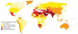
Map of global water stress (a symptom of water scarcity) in 2019. Water stress is the ratio of water use relative to water availability and is therefore a demand-driven scarcity.
Water scarcity (closely related to water stress or water crisis) is the lack of fresh water resources to meet the standard water demand. There are two type of water scarcity. One is physical. The other is economic water scarcity. Physical water scarcity is where there is not enough water to meet all demands. This includes water needed for ecosystems to function. Regions with a desert climate often face physical water scarcity. Central Asia, West Asia, and North Africa are examples of arid areas. Economic water scarcity results from a lack of investment in infrastructure or technology to draw water from rivers, aquifers, or other water sources. It also results from weak human capacity to meet water demand. Many people in Sub-Saharan Africa are living with economic water scarcity.
There is enough freshwater available globally and averaged over the year to meet demand. As such, water scarcity is caused by a mismatch between when and where people need water, and when and where it is available. One of the main causes of the increase in global water demand is the increase in the number of people. Others are the rise in living conditions, changing diets (to more animal products), and expansion of irrigated agriculture. Climate change (including droughts or floods), deforestation, water pollution and wasteful use of water can also mean there is not enough water. These variations in scarcity may also be a function of prevailing economic policy and planning approaches. (Full article...) -

King Sargon II of the Neo-Assyrian Empire (right) had the full titulature of Great King, Mighty King, King of the Universe, King of Assyria, King of Babylon, King of Sumer and Akkad. Stele housed at the British Museum, London.
King of the Universe (Sumerian: lugal ki-sár-ra or lugal kiš-ki, Akkadian: šarru kiššat māti, šar-kiššati or šar kiššatim), also interpreted as King of Everything, King of the Totality, King of All or King of the World, was a title of great prestige claiming domination of the world or the known universe used by powerful monarchs in ancient Mesopotamia. The title is sometimes applied to God in the Abrahamic tradition.
The etymology of the title derives from the ancient Sumerian city of Kish (Sumerian: kiš, Akkadian: kiššatu), the original meaning being King of Kish. Although the equation of šar kiššatim as literally meaning "King of the Universe" was made during the Akkadian period, the title of "King of Kish" is older and was already seen as particularly prestigious, as the city of Kish was seen as having primacy over all other Mesopotamian cities. In Sumerian legend, Kish was the location where the kingship was lowered to from heaven after the legendary Flood. (Full article...) -

Poster advertising the Brussels International Exposition in 1897
A world's fair, also known as a universal exhibition or an expo, is a large global exhibition designed to showcase the achievements of nations. These exhibitions vary in character and are held in different parts of the world at a specific site for a period of time, typically between three and six months.
The term "world's fair" is commonly used in the United States, while the French term, Exposition universelle ("universal exhibition") is used in most of Europe and Asia; other terms include World Expo or Specialised Expo, with the word expo used for various types of exhibitions since at least 1958. (Full article...) -

Sand and dunes of the Libyan Desert
A desert is a landscape where little precipitation occurs and, consequently, living conditions create unique biomes and ecosystems. The lack of vegetation exposes the unprotected surface of the ground to denudation. About one-third of the land surface of the Earth is arid or semi-arid. This includes much of the polar regions, where little precipitation occurs, and which are sometimes called polar deserts or "cold deserts". Deserts can be classified by the amount of precipitation that falls, by the temperature that prevails, by the causes of desertification or by their geographical location.
Deserts are formed by weathering processes as large variations in temperature between day and night put strains on the rocks, which consequently break in pieces. Although rain seldom occurs in deserts, there are occasional downpours that can result in flash floods. Rain falling on hot rocks can cause them to shatter, and the resulting fragments and rubble strewn over the desert floor are further eroded by the wind. This picks up particles of sand and dust, which can remain airborne for extended periods – sometimes causing the formation of sand storms or dust storms. Wind-blown sand grains striking any solid object in their path can abrade the surface. Rocks are smoothed down, and the wind sorts sand into uniform deposits. The grains end up as level sheets of sand or are piled high in billowing sand dunes. Other deserts are flat, stony plains where all the fine material has been blown away and the surface consists of a mosaic of smooth stones, often forming desert pavements, and little further erosion takes place. Other desert features include rock outcrops, exposed bedrock and clays once deposited by flowing water. Temporary lakes may form and salt pans may be left when waters evaporate. There may be underground sources of water, in the form of springs and seepages from aquifers. Where these are found, oases can occur. (Full article...) -
The United Nations uses three definitions for what constitutes a city, as not all cities in all jurisdictions are classified using the same criteria. Cities may be defined as the cities proper, the extent of their urban area, or their metropolitan regions. (Full article...)
-
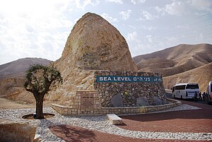
This marker indicating sea level is situated between Jerusalem and the Dead Sea.
Mean sea level (MSL, often shortened to sea level) is an average surface level of one or more among Earth's coastal bodies of water from which heights such as elevation may be measured. The global MSL is a type of vertical datum – a standardised geodetic datum – that is used, for example, as a chart datum in cartography and marine navigation, or, in aviation, as the standard sea level at which atmospheric pressure is measured to calibrate altitude and, consequently, aircraft flight levels. A common and relatively straightforward mean sea-level standard is instead a long-term average of tide gauge readings at a particular reference location.
Sea levels can be affected by many factors and are known to have varied greatly over geological time scales. Current sea level rise is mainly caused by human-induced climate change. When temperatures rise, mountain glaciers and polar ice sheets melt, increasing the amount of water in the oceans, while the existing seawater also expands with heat. Because most of human settlement and infrastructure was built in response to a more-normalized sea level with limited expected change, populations affected by sea level rise will need to invest in climate adaptation to mitigate the worst effects or, when populations are at extreme risk, a process of managed retreat. (Full article...)


General images -
-
 Tiktaalik, a fish with limb-like fins and a predecessor of tetrapods. Reconstruction from fossils about 375 million years old. (from History of Earth)
 -
 A reconstruction of human history based on fossil data. (from History of Earth)
 -

-

-
 Benin Bronze head from Nigeria
 -
 Olmec colossal head, now at the Museo de Antropología de Xalapa
 -
 Battle during the 1281 Mongol invasion of Japan
 -
 An artist's impression of ice age Earth at glacial maximum. (from History of Earth)
 -
 An animation of the changing density of productive vegetation on land (low in brown; heavy in dark green) and phytoplankton at the ocean surface (low in purple; high in yellow) (from Earth)
 -

-
 Artist's impression of the enormous collision that probably formed the Moon (from History of Earth)
 -
 Angkor Wat temple complex, Cambodia, early 12th century
 -
 A map of heat flow from Earth's interior to the surface of Earth's crust, mostly along the oceanic ridges (from Earth)
 -
 Lithified stromatolites on the shores of Lake Thetis, Western Australia. Archean stromatolites are the first direct fossil traces of life on Earth. (from History of Earth)
 -
 Peopling of the world, the Southern Dispersal scenario
 -
 Pale orange dot, an artist's impression of Early Earth, featuring its tinted orange methane-rich early atmosphere (from Earth)
 -
 Ming dynasty section, Great Wall of China
 -

-
 A banded iron formation from the 3.15 Ga Moodies Group, Barberton Greenstone Belt, South Africa. Red layers represent the times when oxygen was available; gray layers were formed in anoxic circumstances. (from History of Earth)
 -
 Florence, birthplace of the Italian Renaissance
 -
 Ajloun Castle, Jordan
 -
 A schematic view of Earth's magnetosphere with solar wind flowing from left to right (from Earth)
 -

-
 Pangaea was a supercontinent that existed from about 300 to 180 Ma. The outlines of the modern continents and other landmasses are indicated on this map. (from History of Earth)
 -
 Trilobites first appeared during the Cambrian period and were among the most widespread and diverse groups of Paleozoic organisms. (from History of Earth)
 -

-

-
 Vitruvian Man by Leonardo da Vinci epitomizes the advances in art and science seen during the Renaissance. (from History of Earth)
 -
 Machu Picchu, Inca Empire, Peru
 -
 Great Pyramids of Giza, Egypt
 -
 Artist's impression of Earth during the later Archean, the largely cooled planetary crust and water-rich barren surface, marked by volcanoes and continents, features already round microbialites. The Moon, still orbiting Earth much closer than today and still dominating Earth's sky, produced strong tides. (from History of Earth)
 -
 A view of Earth with its global ocean and cloud cover, which dominate Earth's surface and hydrosphere; at Earth's polar regions, its hydrosphere forms larger areas of ice cover. (from Earth)
 -
 Shanghai. China urbanized rapidly in the 21st century.
 -
 A 580 million year old fossil of Spriggina floundensi, an animal from the Ediacaran period. Such life forms could have been ancestors to the many new forms that originated in the Cambrian Explosion. (from History of Earth)
 -
 A computer-generated image mapping the prevalence of artificial satellites and space debris around Earth in geosynchronous and low Earth orbit (from Earth)
 -

-
 A composite image of Earth, with its different types of surface discernible: Earth's surface dominating Ocean (blue), Africa with lush (green) to dry (brown) land and Earth's polar ice in the form of Antarctic sea ice (grey) covering the Antarctic or Southern Ocean and the Antarctic ice sheet (white) covering Antarctica. (from Earth)
 -
 "Lucy", the first Australopithecus afarensis skeleton found, was only 1.06 m (3 ft 6 in) tall.
 -

-
 Artist's rendition of an oxinated fully-frozen Snowball Earth with no remaining liquid surface water. (from History of Earth)
 -
 Tracy Caldwell Dyson, a NASA astronaut, observing Earth from the Cupola module at the International Space Station on 11 September 2010 (from Earth)
 -

-
 First airplane, the Wright Flyer, flew on 17 December 1903.
 -
 View of Earth from the Moon by the Lunar Reconnaissance Orbiter (from Earth)
 -
 Standing Buddha from Gandhara, 2nd century CE
 -
 Japanese depiction of a Portuguese carrack. European maritime innovations led to proto-globalization.
 -
 Cross-section through a liposome (from History of Earth)
 -
 Notre-Dame de Paris, France
 -
 A pillar at Göbekli Tepe
 -

-

-
 Great Mosque of Kairouan, Tunisia, founded 670 CE
 -

-
 Chloroplasts in the cells of a moss (from History of Earth)
 -
 Graph showing range of estimated partial pressure of atmospheric oxygen through geologic time (from History of Earth)
 -
 Artist's conception of Devonian flora (from History of Earth)
 -
 Earth's axial tilt causing different angles of seasonal illumination at different orbital positions around the Sun (from Earth)
 -
 Earth's western hemisphere showing topography relative to Earth's center instead of to mean sea level, as in common topographic maps (from Earth)
 -
 Yggdrasil, an attempt to reconstruct the Norse world tree which connects the heavens, the world, and the underworld. (from World)
 -
 Obelisk of Axum, Ethiopia
 -
 Satellite time lapse imagery of Earth's rotation showing axis tilt (from Earth)
 -

-
 Image of the physical world, captured by the Hubble Space Telescope (from World)
 -
 A view of Earth with different layers of its atmosphere visible: the troposphere with its clouds casting shadows, a band of stratospheric blue sky at the horizon, and a line of green airglow of the lower thermosphere around an altitude of 100 km, at the edge of space (from Earth)
 -
 A 2012 artistic impression of the early Solar System's protoplanetary disk from which Earth and other Solar System bodies were formed (from Earth)
 -
 Artist's conception of Hadean Eon Earth, when it was much hotter and inhospitable to all forms of life. (from History of Earth)
 -
 A reconstruction of Pannotia (550 Ma). (from History of Earth)
 -
 Earth's night-side upper atmosphere appearing from the bottom as bands of afterglow illuminating the troposphere in orange with silhouettes of clouds, and the stratosphere in white and blue. Next the mesosphere (pink area) extends to the orange and faintly green line of the lowest airglow, at about one hundred kilometers at the edge of space and the lower edge of the thermosphere (invisible). Continuing with green and red bands of aurorae stretching over several hundred kilometers. (from Earth)
 -
 The replicator in virtually all known life is deoxyribonucleic acid. DNA is far more complex than the original replicator and its replication systems are highly elaborate. (from History of Earth)
 -

-
 Dinosaurs were the dominant terrestrial vertebrates throughout most of the Mesozoic (from History of Earth)
 -
 Earth's history with time-spans of the eons to scale (from History of Earth)
 -
 A composite image of artificial light emissions at night on a map of Earth (from Earth)
 -
 Chennakesava Temple, Belur, India
 -
 Fall of the Berlin Wall, 1989
 -
 Earth's land use for human agriculture in 2019 (from Earth)
 -

-
 Taj Mahal, Mughal Empire, India
 -
 Empires of the world in 1898
 -
An artist's impression of the Archean, the eon after Earth's formation, featuring round stromatolites, which are early oxygen-producing forms of life from billions of years ago. After the Late Heavy Bombardment, Earth's crust had cooled, its water-rich barren surface is marked by continents and volcanoes, with the Moon still orbiting Earth half as far as it is today, appearing 2.8 times larger and producing strong tides. (from Earth)
-

-
 Persepolis, Achaemenid Empire, 6th century BCE
 -
 Geologic map of North America, color-coded by age. From most recent to oldest, age is indicated by yellow, green, blue, and red. The reds and pinks indicate rock from the Archean.
 -
The pale orange dot, an artist's impression of the early Earth which might have appeared orange through its hazy methane rich prebiotic second atmosphere. Earth's atmosphere at this stage was somewhat comparable to today's atmosphere of Titan. (from History of Earth)
-
 Change in average surface air temperature and drivers for that change. Human activity has caused increased temperatures, with natural forces adding some variability. (from Earth)
 -
 Last Moon landing: Apollo 17 (1972)
 -
 Artist's impression of a Hadean landscape with the relatively newly formed Moon still looming closely over Earth and both bodies sustaining strong volcanism. (from History of Earth)
 -
 An artist's rendering of a protoplanetary disk (from History of Earth)


.jpg)


.svg)


.jpg)

.jpeg)


.jpg)


Megacities of the world -

Bangalore (/ˈbæŋɡəlɔːr, ˌbæŋɡəˈlɔːr/ BANG-gə-lor, -LOR), officially Bengaluru (Kannada pronunciation: [ˈbeŋgɐɭuːɾu] ), is the capital and largest city of the southern Indian state of Karnataka. It has a population of more than 8 million and a metropolitan population of around 15 million, making it India's third most populous city and fourth most populous urban agglomeration. It is the most populous city and largest urban agglomeration in South India, and is the 27th largest city in the world. Located on the Deccan Plateau, at a height of over 900 m (3,000 ft) above sea level, Bangalore has a pleasant climate throughout the year, with its parks and green spaces earning it the reputation of India's "Garden City". Its elevation is the highest of India's major cities.
The city's history dates back to around 890, as per the old Kannada stone inscription found at the Nageshwara Temple in Begur, Bangalore. In 1537, Kempé Gowdā, a feudal ruler under the Vijayanagara Empire, established a mud fort, considered the foundation of modern Bangalore and its oldest areas, or pétés, which still exist. After the fall of the Vijayanagara Empire, Kempe Gowda declared independence; in 1638, a large Adil Shahi Bijapur army defeated Kempe Gowda III, and Bangalore came under Shahaji Bhonsle as a jagir, which later became his capital. The Mughals later captured Bangalore and sold it to Maharaja Devaraja Wodeyar II of the Kingdom of Mysore. When Haider Ali seized control of the kingdom, Bangalore's administration passed into his hands. (Full article...)Did you know -

- ... that in 2021 Krisztofer Mészáros became the first Hungarian male gymnast in 22 years to qualify for a World Artistic Gymnastics Championships all-around final?
- ... that the Te'omim Cave in Israel was home to a Bronze Age alabaster quarry, a refuge cave during the Jewish–Roman wars, and a possible center for necromantic activity in late antiquity?
- ... that the developers of Sonic felt the series' linear design contained "little room for evolution" so they decided to make Sonic Frontiers an open world game?
- ... that as Malaysian prime minister, Mahathir Mohamad called the outcomes of the 1992 Earth Summit "eco-imperialism"?
- ... that Francis Fogarty, who went on to manage an NFL franchise for nearly two decades, was taken prisoner by the Nazis in World War II but managed to escape while wounded?
- ... that the novel Mama Dear by Christine Haidegger details her childhood in post–World War II Austria?
- ... that Eva Duldig, who was interned by Australia during the Second World War, later represented the country at the Wimbledon Championships?
- ... that Valentine Strudwick enlisted to serve in the First World War at 14 years old?
Countries of the world -

Laos, officially the Lao People's Democratic Republic (Lao PDR or LPDR), is the only landlocked country in Southeast Asia. At the heart of the Indochinese Peninsula, Laos is bordered by Myanmar and China to the northwest, Vietnam to the east, Cambodia to the southeast, and Thailand to the west and southwest. Its capital and largest city is Vientiane.
Present-day Laos traces its historic and cultural identity to Lan Xang, which existed from the 13th century to the 18th century as one of the largest kingdoms in Southeast Asia. Because of its central geographical location in Southeast Asia, the kingdom became a hub for overland trade and became wealthy economically and culturally. After a period of internal conflict, Lan Xang broke into three separate kingdoms: Luang Phrabang, Vientiane and Champasak. In 1893, the three kingdoms came under a French protectorate and were united to form what is now known as Laos. (Full article...)
The Seven Wonders of Ukraine (Ukrainian: Сім чудес України [ˈsʲim tʃʊˈdɛs ʊkrɐˈjinɪ]) are seven historical and cultural monuments of Ukraine, which were chosen in the Seven Wonders of Ukraine contest held in July, 2007. This was the first public contest of that kind which was followed by the Seven Natural Wonders of Ukraine, the Seven Wonderful Routes of Ukraine, and the Seven Wonderful Castles of Ukraine. All nominated sites are publicly owned protected areas of at least regional level, available for tourism.
The voting for all contests consisted of two parts: experts in Ukraine voted for their seven best sites, and internet users voted for their seven favorite sites on the official website. (Full article...)Related portals
Protected areas of the world -
-

Flamingos at the Ras Al Khor Wildlife Sanctuary
This is a list of protected areas of United Arab Emirates:- Abu Dhabi Mangrove and Coastal Wetland Reserve
- Ain al Faydah National Park
- Al Awir Nature Reserve
- Al Khawanij Nature Reserve
- Al Maha Nature Reserve
- Al Marmoom Desert Conservation Reserve
- Al Wohoosh Desert Conservation Reserve
- Dubai Desert Conservation Reserve National Park
- Hatta Nature Reserve
- Jabal Ali Wildlife Sanctuary
- Khor Kalba Nature Reserve
- Marawah Marine Protected Area
- Mushrif National Park
- Nadd Al Sheba Nature Reserve
- Rams Lagoon Reserve
- Ras Al Khor Wildlife Sanctuary
- Wadi Wurayah National Park
- Zirkuh Island Bird Sanctuary
-

Part of the Brecon Beacons National Park, looking from the highest point of Pen y Fan (886 m/2907 feet) to Cribyn (795 m/2608 feet).
Protected areas of the United Kingdom are areas in the United Kingdom which need and /or receive protection because of their environmental, historical or cultural value to the nation. Methods and aims of protection vary depending on the nature and importance of the resource. Protection operates at local, regional, national and international levels, and may be backed by legislation and international treaty, or less formally by planning policy.
Within the United Kingdom, different approaches are taken to some forms of protection within the constituent countries of England, Scotland, Wales and Northern Ireland, while other forms of protection are more consistent across the UK. Protected areas can be divided according to the type of resource which each seeks to protect. Primarily, these are: scenic or landscape value; biodiversity value (species and habitats); geodiversity value (relating to geology and geomorphology); and cultural or historic value. Several types of protected areas are focused on more than one of these areas. (Full article...) -
This is a list of protected areas of Ontario that are administered by Government of Ontario. Ontario Parks and the Ministry of the Environment, Conservation and Parks are the provincial bodies responsible for managing these protected areas. (Full article...)
-
Protected areas of Ukraine (Ukrainian: охоронні території) are special areas of Ukraine established with the goal of protecting the natural and cultural heritage of the country from excessive changes as a result of human activity. The protection of the areas is the responsibility of the government of Ukraine, specifically the Cabinet of Ministers of Ukraine.
Ukraine has several categories of protected areas of Ukraine and the protected areas include: (Full article...) -

A view at Kintrishi National Park
The South Caucasian nation of Georgia is home to several protected areas, which receive protection because of their environmental, cultural or similar value. The oldest of these – now known as the Lagodekhi Protected Areas – dates back to 1912, when Georgia was part of the Russian Empire.
The total area of Georgia's protected terrestrial territories is 6,501 km2 (2,510 sq mi), which amounts to approximately 9.29% of the country's territory. In addition 153 km2 (59 sq mi) of marine area protected, or 0.67% of the country's territorial waters. There are a total of 89 protected areas, including 14 Strict Nature Reserves, 12 National Parks, 20 Managed Nature Reserves, 40 Natural Monuments, 2 Ramsar sites and 1 Protected Landscape. Strict nature reserves comprise 140,672 ha, while national parks cover 276,724 ha. The total number of visitors to Georgia's protected areas was just under 1.2 million in 2019. (Full article...) -
-

Wales, a country that is part of the United Kingdom, contains protected areas under various designations. The largest designation by land area is Wales' three national parks, followed by the five Areas of Outstanding Natural Beauty (sometimes collectively the "Designated Landscapes of Wales").
Among these protected areas is Snowdonia (Eryri), Wales' first and the UK's third designated national park, and the Gower AONB covering parts of the Gower Peninsula being both Wales' and the UK's first Area of Outstanding Natural Beauty (AONB), as well as smaller designations. (Full article...) -
The Australian Capital Territory as of 2014 contains 46 separate protected areas with a total land area of 1,302 km2 (503 sq mi) or 55.5% of the territory's area, and which managed by Territory and Municipal Services of the ACT government: (Full article...)
-

There are numerous parks throughout the sovereign island country of Singapore. This is a list of parks in Singapore that are currently existing and have articles on Wikipedia. Most parks in Singapore are managed by the National Parks Board, although smaller neighbourhood parks are managed by the Housing Development Board. Most of these parks are connected via the Park Connector Network (PCN). (Full article...) -
Protected areas of Slovakia are areas that need protection because of their environmental, historical or cultural value to the nation. Protected areas in Slovakia are managed by institutions and organizations governed by the Ministry of the Environment.
Types of protected areas:- National Park (Slovak: Národný park; abbr. NP)
- Protected Landscape Area (Chránená krajinná oblasť; CHKO)
- National Nature Reserve (Národná prírodná rezervácia; NPR)
- Nature Reserve (Prírodná rezervácia; PR)
- National Nature Monument (Národná prírodná pamiatka; NPP)
- Nature Monument (Prírodná pamiatka; PP)
- Protected Site (Chránený areál; CHA)
- Protected Landscape Element (Chránený krajinný prvok; CHKP)
- Protected Bird Area* (Chránené vtáčie územie; CHVÚ) *Technically Special Protection Area (SPA) under the EU Bird's Directive
- Protected Tree (Chránený strom; CHS)
-

Network of protected areas in Albania (2020)
Despite being a relatively small country, Albania is exceedingly rich in biodiversity. Its ecosystems and habitats support over 5,550 species of vascular and non-vascular plants and more than 15,600 species of coniferous and non-coniferous evergreens, most of which are threatened at global and European levels. The country has made recent efforts to expand its network of protected areas which now include: 11 national parks, 1 marine park, 718 nature monuments, 23 managed nature reserves, 11 protected landscapes, 4 World Heritage Sites, 4 Ramsar sites and other protected areas of various categories, that when combined, account for 21.36% of the territory. Furthermore, a biosphere reserve, 45 important plant areas and 16 important bird areas are found in the country.
Meanwhile, the central government has proclaimed the Coastline and the Tirana Greenbelt as areas of national importance. (Full article...) -

West Matukituki Valley and the Matukituki River seen from Cascade Saddle in Mount Aspiring National Park
Protected areas of New Zealand are areas that are in some way protected to preserve their environmental, scientific, scenic, historical, cultural or recreational value. There are about 10,000 protected areas, covering about a third of the country. The method and aims of protection vary according to the importance of the resource and whether it is publicly or privately owned.
Nearly 30 percent of New Zealand's land mass is publicly owned with some degree of protection. Most of this land – about 80,000 square kilometres (31,000 sq mi) – is administered by the Department of Conservation. There are 13 national parks, thousands of reserves, 54 conservation parks, and a range of other conservation areas. (Full article...) -

Total size of protected area of Bosnia and Herzegovina amounts of 57.83694 hectares (142.9182 acres), which is 1,13% of its entire territory. This is a list of areas protected by corresponding levels of the government of Bosnia and Herzegovina, namely at the entity's levels, and with various categorizations. (Full article...) -

Grand Canyon of Yellowstone
The protected areas of the United States are managed by an array of different federal, state, tribal and local level authorities and receive widely varying levels of protection. Some areas are managed as wilderness, while others are operated with acceptable commercial exploitation. , the 42,826 protected areas covered 1,235,486 km2 (477,024 sq mi), or 13 percent of the land area of the United States. This is also one-tenth of the protected land area of the world. The U.S. also had a total of 871 National Marine Protected Areas, covering an additional 1,240,000 sq mi (3,200,000 km2), or 26 percent of the total marine area of the United States. (Full article...) -
Protected areas of Turkmenistan include nine nature reserves (zapovednik) and 13 sanctuaries (zakaznik) with a total area of 19,750 km2 or more than 4% of Turkmenistan's territory. (Full article...)


.svg)

.svg)


Selected world maps
-
 Time zones of the world
 -
 Only a few of the largest large igneous provinces appear (coloured dark purple) on this geological map, which depicts crustal geologic provinces as seen in seismic refraction data
 -
 The world map by Gerardus Mercator (1569), the first map in the well-known Mercator projection
 -
 Index map from the International Map of the World (1:1,000,000 scale)
 -
 United Nations Human Development Index map by country (2016)
 -
 Mollweide projection of the world
 -
 1516 map of the world by Martin Waldseemüller
 -
 The Goode homolosine projection is a pseudocylindrical, equal-area, composite map projection used for world maps.
 -
 A plate tectonics map with volcano locations indicated with red circles


World records
- List of Olympic records in athletics
- List of world records in athletics
- List of junior world records in athletics
- List of world records in masters athletics
- List of world youth bests in athletics
- List of IPC world records in athletics
- List of world records in canoeing
- List of world records in chess
- List of cycling records
- List of world records in track cycling
- List of world records in finswimming
- List of world records in juggling
- List of world records in rowing
- List of world records in speed skating
- List of world records in swimming
- List of IPC world records in swimming
- List of world records in Olympic weightlifting
Topics

Continents of Earth | ||||||||
|---|---|---|---|---|---|---|---|---|
| ||||||||
| ||||||||
| ||||||||


| Cenozoic Era (present–66.0 Ma) |
| ||||||||||||
|---|---|---|---|---|---|---|---|---|---|---|---|---|---|
| Mesozoic Era (66.0–252 Ma) |
| ||||||||||||
| Paleozoic Era (252–539 Ma) |
| ||||||||||||
| Proterozoic Eon (539 Ma–2.5 Ga) |
| ||||||||||||
| Archean Eon (2.5–4 Ga) | |||||||||||||
| Hadean Eon (4–4.6 Ga) | |||||||||||||
ka = kiloannum (thousands years ago); Ma = megaannum (millions years ago); Ga = gigaannum (billions years ago). See also: Geologic time scale • | |||||||||||||
| Locations | ||
|---|---|---|
| Related | ||

| |||||||||||||||||||
| |||||||||||||||||||
| |||||||||||||||||||

Economic classification of countries | |||||
|---|---|---|---|---|---|
| Three-World Model | |||||
| Gross domestic product (GDP) |
| ||||
| Gross national income (GNI) | |||||
| Wages | |||||
| Wealth | |||||
| Other national accounts | |||||
| Human development | |||||
| Digital divide | |||||
| Net international investment position (NIIP) | |||||
| Technological |
| ||||
|---|---|---|---|---|---|
| Sociological | |||||
| Ecological |
| ||||
| Biological |
| ||||
| Astronomical | |||||
| Eschatological |
| ||||
| Others |
| ||||
| Fictional | |||||
| Organizations | |||||
Categories

Wikimedia
The following Wikimedia Foundation sister projects provide more on this subject:
-
 Commons
Free media repository -
 Wikibooks
Free textbooks and manuals -
 Wikidata
Free knowledge base -
 Wikinews
Free-content news -
 Wikiquote
Collection of quotations -
 Wikisource
Free-content library -
 Wikispecies
Directory of species -
 Wikiversity
Free learning tools -
 Wikivoyage
Free travel guide -
 Wiktionary
Dictionary and thesaurus


