
A815 road (Scotland)
 | |
|---|---|
 The northern terminus of the road (right), looking east along the A83 | |
| Route information | |
| Length | 35.7 mi (57.5 km) |
| Major junctions | |
| North end | A83 |
| South end | Emergence from an unnamed road in Toward |
| Location | |
| Country | United Kingdom |
| Road network | |
The A815 is a major road located in Argyll and Bute, Scotland. It runs for about 35.7 miles (57.5 km) from the A83, near Cairndow, in the north to Toward in the south.[1] It passes beside three lochs, while its final stretch is along the Firth of Clyde.
Route[edit]
The road begins at a T-junction with the A83, about 0.7 miles (1.1 km) east of Ardkinglas Woodland Garden.[2] The road immediately crosses the Kinglas Water and turns west and then south-west, along the eastern shores of Loch Fyne. Between Creggans and Strachur, at the junction with the A886, road turns south-east at the A886, heading inland, soon following the River Cur and then Loch Eck, again on the eastern side, and turns south. It passes Benmore (and Benmore Botanic Garden)[3] and Uig en route to Ardbeg, below Puck's Glen to the north.[4]
After a few sweeping curves where the A880 branches off, just north of Dalinlongart the road crosses the Little Eachaig River,[5] turns south-east, and continues beside the northern end of the Holy Loch on its western shores
In Sandbank, at a T-junction with the A885 High Road (which leads to and from the northern end of Dunoon and links up with the A815 at East Bay), the road turns left towards the Holy Loch Marina.
At the mouth of the Holy Loch, at the western shores of the Firth of Clyde, the road turns south as it leads through Hunters Quay and enters the town of Dunoon. As Alexandra Parade, the road continues through Hunters Quay and Kirn.
En route to Dunoon's East Bay, the road passes several roads that lead up and down the hill perpendicular to the Firth of Clyde. They are: Kirn Brae, Stewart Street, Clyde Street and Dhalling Road. Several others, not mentioned here, are cul-de-sacs.
Still as Alexandra Parade, the road crosses a roundabout shared with John Street (the southern end of the A885 which diverged at Sandbank), then passes Church Street, Moir Street and the eastern end of Argyll Street.
The road continues past Dunoon Pier and crosses the roundabout overlooked by the Highland Mary statue. As Wellington Street, it then sweeps a few hundred feet inland, on a pronounced curve to the east, forming junctions with Park Avenue, Kirk Street, Castle Street, Jane Street, Hillfoot Street, Victoria Road, Auchamore Road, (another) Clyde Street, William Street and Victoria Parade.
At West Bay, after passing the western end of Victoria Parade, the road turns south again as Pier Esplanade. After leaving Dunoon, the road continues for a further 5 miles (8.0 km) south along the west bank of the firth, passing through Bullwood, Ardhallow and Innellan.
Finally the road reaches Toward, which marks the junction of the Kyles of Bute and the Firth, and turns west at its junction with an unnamed road which leads south to the centre of Toward, and soon ends around 1,700 feet (520 m) west of Toward Church.
Name[edit]

Its name changes several times over its course (from north to south):
- Shore Road (Ardnadam to Sandbank)
- Marine Parade (Kirn to Hunters Quay)
- Alexandra Parade (from Argyll Street to Kirn)
- Pier Esplanade (from East Bay, Dunoon, to Argyll Street, Dunoon)
- Wellington Street (through Dunoon)
- Bullwood Road (between Innellan and West Bay, Dunoon)
- Shore Road (between Toward and Innellan)
Notable building and structures[edit]

The following buildings, structures or sites of interest stand (or formerly stood) beside the road (from north to south):
- Coylet Inn, a 17th-century coaching inn[6]
- Whistlefield Inn
- Benmore Botanic Garden
- Lazaretto Point War Memorial
- Hafton House, Hunters Quay
- Royal Marine Hotel, Hunters Quay
- Hunters Quay Hotel, Hunters Quay
- Queen's Hotel, Kirn
- Kirn & Sandbank Parish Church, Dunoon
- Dunoon Pier, Dunoon
- Highland Mary statue, Dunoon
- Laudervale, Dunoon (the now-demolished former home of Sir Harry Lauder)[7]
Viewpoints[edit]
-
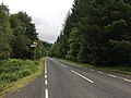 Between Strachur and Dunoon
 -
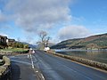 Beside the Holy Loch, looking northwest
 -
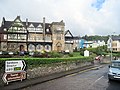 The road passing in front of the Royal Marine Hotel in Hunters Quay
 -
 Alexandra Parade in Kirn, looking north
 -
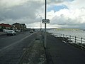
 Looking south to Dunoon
.jpg)


.jpg)
References[edit]
- ^ (Route A815 Cairndow-Strachur-Toward Road) (Loch Eck) (40 mph speed limit), Order 201 - Argyll and Bute Council
- ^ Finlay, Ross (1986). Journey Through Scotland. Gallery Books. ISBN 9780831752620.
- ^ "Appeal following fatal road crash in Dunoon - Police Scotland". www.scotland.police.uk. Retrieved 23 May 2022.
- ^ Edinburgh, Royal Botanic Garden. "Benmore Botanic Garden | Visit". www.rbge.org.uk. Retrieved 23 May 2022.
- ^ An Inventory of Gardens and Designed Landscapes in Scotland: Dumfries and Galloway and Strathclyde. 1987. p. 182.
- ^ "Coylet Inn | Welcome to Argyll and Bute Council's Marriage and Civil Ceremonies Website". www.argyll-bute.gov.uk. Retrieved 23 May 2022.
- ^ Phil Miller (23 April 2010). "Fly me to Dunoon ... Scottish bid for de Niro's film festival". Herald Scotland. Retrieved 27 October 2011.
External links[edit]
A roads in Zone 8 of the Great Britain road numbering scheme | ||
|---|---|---|